Riverdale Collegiate

by Joanne Doucette

A ghostly Riverdale Collegiate stands behind an orchard. Workers with pick and shovel fill in the Devil’s Hole or Devil’s Hollow, a ravine cut by Hastings Creek and widened and deepened by brickmakers. Nearby Harriet’s Hill shows how deep the hole really was and even the bottom of the gully there has been filled in with brickyard waste — broken bricks and cinders. Riverdale Collegiate itself was built of those deep red bricks from the local brickyards.

1910 Devils Hollow labelled
1910 map with my labels. 

There is an urban legend that Myrtle, Ivy and Harriet Streets were named after local women (true) who argued so much that they could never meet so the streets don’t meet (not true). The deep ravine called “the Devil’s Hollow” had more to do with keeping the streets from meeting. The women were all members of local brickmaking families who actually seemed to have got along quite well.


5
This is likely along Hasting’s Creek near Riverdale Collegiate. Note the orchard at the top of the bank. The Clay Worker, November, 1906.

Slide 22
The area was still quite rural in 1907 when Riverdale Collegiate began as can be seen in this photo of Pape Avenue looking north from about the railroad tracks.

Slide 23b
A cartoon appealing for British immigrants to come to Toronto. From the Globe, March 19, 1908. 

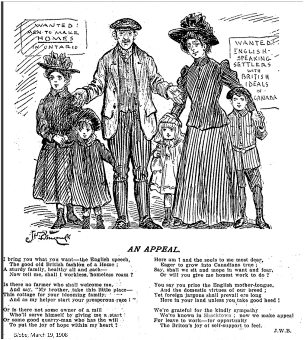
Canada’s immigration policy was openly racist and specifically sought white Scottish, Irish and English immigrants to counter the feared “Yellow Peril” — immigration from China and, to a lesser degree, Japan. This is clearly and, none to subtly, reflected in the poem below. John Wilson Bengough (1851-1923) was one of Canada’s leading cartoonists.

Slide 23a

British immigrants crossing the “Bridge of Tears” over the railway tracks at Union Station around 1911. It was called this because here people said goodbye to loved ones or cried because they had left everything they had to gamble on a new start in a new country. Everything they own is in their hands.

Most came in family groups like this. Mother has baby in her arms. Dad is at the back. Two teens carry the luggage and grandmother is at the back carrying another child. The grinning child on the right reflects the hope they had, but others don’t look so enthralled with Toronto.

Slide 24

At the same time that a Shacktown was growing outside the city, families like the Andersons built brick and brick-fronted houses like these west of Greenwood Avenue. The City of Toronto imposed stricter building requirements due to the danger of fire. The so-called “Fire Limits” required brick construction at least on the street facade and fire resistant cladding on the other walls. Much of that cladding was Insulbrick, a kind of asphalt impregnated with asbestos. There is still a lot of that material around, often covered with newer aluminum siding.

The Andersons, professional builders from Scotland, preferred to build solid brick, sturdy houses, like these three. Many of those still stand today near Riverdale Collegiate. (Photos courtesy of Guy Anderson)

Slide 25

After 1905 a Shacktown developed east of Greenwood Avenue on land that was still outside of the limits of the City of Toronto. A flood of impoverished British immigrants arrived here to start new lives only to find that while jobs were available (at least at first), there was no housing for them. So they bought lots at around $5 to $10 a foot of frontage and scrounged bits of lumber, old crates, tarpaper, tin and whatever could use to create their own homes. These are on Coxwell Avenue.

Slide 26
City of Toronto Building Construction Dates City of Toronto Works and Emergency Services, Technical Services, Survey and Mapping Services, Mapping Services. Produced by Patricia Morphet, September 2003 This map is on line at http://oldtorontomaps.blogspot.com/2014/06/contemporary-maps-with-historical.html

Slide 28
From Goad’s Atlas, 1913, Plate 100, showing Riverdale Collegiate. Curzon Street was later renamed Bushell Avenue north of Gerrard. Bushell may have been named after a brickmaker named Bushell who was killed in World War One. After that bloodbath the City of Toronto renamed a number of small streets after particularly courageous men who died. Another such street is Dibble near Eastern Avenue and McGee.

Skating on Hastings Creek The Devil's Hollow

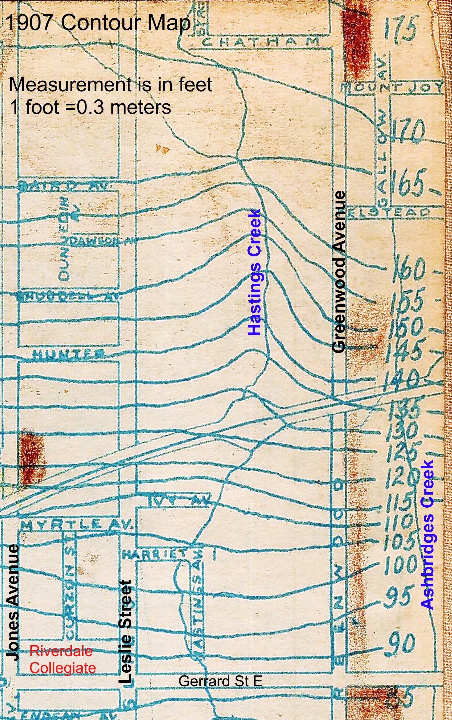
December 22, 1919 Boys playing hockey on Hastings Creek. Hastings Creek crossed the Danforth just east of Jones and cut a ravine at Ravina Crescent in “The Pocket” and another gully, known as the “Devil’s Hollow” between Jones & Greenwood.

The creek continued south through the Hastings’ farm (Hastings Avenue to Alton Avenue) and across where Greenwood Park is to enter Ashbridge’s Bay between Leslie Street and Laing Street. The City filled the ravine in a number of times and finally buried the creek in the sewer system in the early 1920’s.

A staff member at the East End Garden Centre recalled when her grandfather caught fish in this pond. Others have told me of their grandparents tobogganing down the hill or skating on the pond.

Slide 29

Cattle and pigs were driven along roads leading into Leslieville from very early in the 19th century. The men and boys who managed the cattle en route were called “drovers”. Later they were brought in by train. When they reached Leslieville the animals were let loose to graze on the nutritious meadow grasses along Ashbridge’s Bay.

Some were even fed on the leftovers from the Gooderham Worts Distillery. Then they were slaughtered by butchers in the many abattoirs that were feature of Leslieville’s economy. Of the cattle that were fed on whisky mash, it is said that they died happy.

Slide 30

This is looking west along Jones Avenue just north of Riverdale Collegiate. Heavy industry lined the track, including a pork packinghouse on the west side of Jones where pigs where slaughtered. The stench was incredible especially on hot days, making nearby houses and the high school even more uncomfortable in the days before air conditioning,

Contour Map 1908 Hastings Creek labelled
This map was published in 1908 and is based on surveys done in 1907.

Lazeby 1921 TTC close up topo map Leslieville labelled
Hastings Creek has now been put underground as part of the sewer system. The penciled in line just east of Leslie Street may indicate the path of the sewer. By this time the creek was heavily polluted with industrial and human effluent. But public health was coming into its own by the 1920’s and chlorination of drinking water, immunizations against infectious diseases, pasteurization of milk, and the invention of new drugs like penicillin began to revolutionize society in ways that we often don’t recognize today. Nonetheless, the teenagers of Riverdale paid a heavy price in the First World War and Great Flu pandemic that followed. I hope the short history of the Riverdale Collegiate site that I have written will help all of us appreciate young people more through understanding the area that they grew up in.

Slide 31
Globe, Sat., Aug. 31, 1907 On the former exterior south wall, now inside an atrium, a 1965 Toronto Board of Education plaque. This is what it says: “In co-operation with the Riverdale Business Men’s Association, the Toronto Board of Education persisted in building a school on Gerrard Street, named Riverdale Collegiate Institute. The original school, consisting of a principal’s office, library, auditorium, four classrooms and two science rooms, was occupied in 1907.”  Contrary to some sources such as Wikipedia, Riverdale Collegiate Institute was first called Riverdale High School NOT Riverdale Technical School. Riverdale Technical School, founded in 1919 on Greenwood Avenue north of Danforth Avenue was renamed Danforth Technical School.

Slide 32
Colourized postcard, 1907

Slide 33
Photo from The Report of the Dept of Education 1910 By the second and third years, classes had to be held in the cloak rooms. The first addition was completed in 1910 and consisted of the assembly hall and the eight classrooms to the north and south of it.

Slide 34
Photo from Report of the Dept. of Education, 1914. Additions were built in 1914, 1922, and 1924, in accordance with the architect’s original plan for the expansion of the school.

Slide 35
Architect’s blueprint showing planned extension to Riverdale Collegiate. City of Toronto Archives.

Slide 36
Postcard of Riverdale Collegiate after 1924 when additions were added to enlarge the school further. This is likely from an architect’s drawing prepared for that extension to the school.

Riverdale_CI_From_Jones_(Phone)
CC BY 2.5, https://commons.wikimedia.org/w/index.php?curid=1201756

Riverdale_CI_Crest
THE END

Published by Leslieville Historical Society

Welcome to the Leslieville Historical Society's website. Please feel free to join us, to ask questions, to attend walking tours and other events, and to celebrate Leslieville's past while creating our future. Guy Anderson, President, Leslieville Historical Society and Joanne Doucette, local historian and webmaster.

One thought on “Riverdale Collegiate

Leave a comment