
When we look at a photo, especially an old photo, we get the big picture but often miss the details that make the shot tell a story. And there’s even more details that unfolded once I dug into my files. They say that the devil is in the details, but so is the treasure!


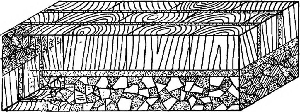
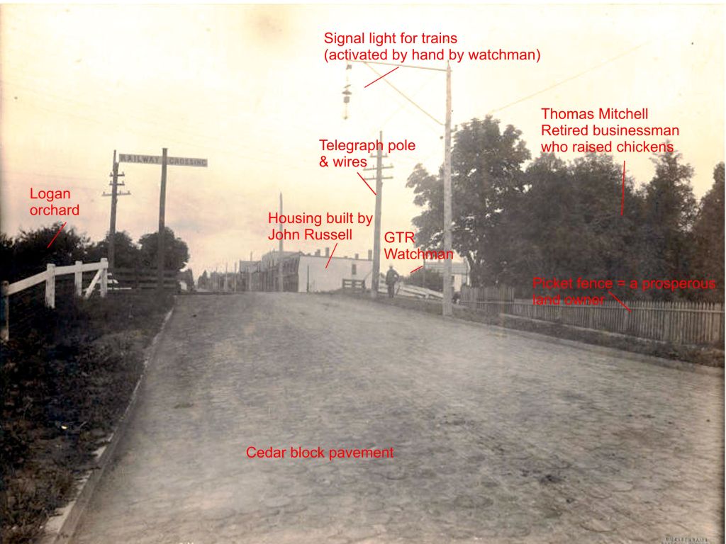
When I looked at the photo in high resolution it was clear that Logan Avenue was paved with cylindrical cedar blocks. Cedar is rot-resistant but broke down over time and the heavy loads of bricks that horses hauled over the blocks. The ruts are visible in the picture.
Better roads were an important enticement for residents who contemplated amalgamation with Toronto. At that time most roads were either dirt, planked or covered with wood blocks. The wood blocks, about eight inches in diameter, were laid down on the street, and held together with tar. Poor people stole the blocks in winter and used them for firewood. Even without these thefts, cedar block roads did not last long. However, obtaining gravel for roads was a problem. The gravel pits at Ben Lamond were treasured. By 1886 the City had laid almost 48 miles of cedar block pavements and 121 miles of sewers. In that year cedar block was laid down on Kingston Road from the Don Bridge to Greenwood’s Lane, the City’s eastern limit. Even walking was not easy. There were few sidewalks in Leslieville and they often were wooden, ramshackle affairs.
Toronto’s Progress in 1886. Public Works constructed during the year. There are now 47.83 miles of cedar block Pavements and 121.2 Miles of Sewers in Toronto. Some interest figures showing increase in all Directions. During the year just past there have been no less than 8.75 miles of cedar block pavements constructed in the city of Toronto. During 1885 there were 6.03 miles of block pavements constructed. There are now 47.83 miles of paved streets in the city. The total mileage of streets in Toronto is 172. The following cedar block pavements have been constructed during 1886:– Kingston Road [now called Queen Street East], Don Bridge to Greenwood’s…Globe, Jan. 1, 1887
Aldermen often preferred the cedar blocks because they were cheaper than many of the alternatives as did some property owners who resented having to pay for the “improvements” in their neighbourhood. But developers wanted good streets, good sidewalks, sewers and the City to pay for all this. John Russell must have found himself conflicted from time to time.
FAVORS CEDAR BLOCK. Mr. George Gooderham Says That Queen Street Cannot Pay For a Better Pavement.
Mr. George Gooderham has addressed a letter to the Council regarding the proposed new pavement in Queen street from the Grand Trunk tracks to Greenwood avenue The Engineer has recommended a block pavement, but several property owners are agitating for asphalt. Mr. Gooderham states that he is a heavy property owner on that part of Queen street, and declares that as much of the land is vacant it cannot maintain the burden of a high local improvement tax. He writes; “I consider that the Engineer has no doubt thought out what was best for the street, and for the ratepayers; further, that the property immediately benefited is not of sufficient value to warrant the laying of a more expensive pavement, and further, I consider a cedar block pavement is quite well suited for the traffic on that part of Queen street.” Toronto Star, September 8, 1900
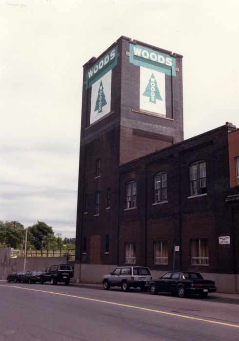
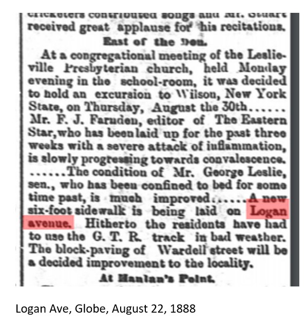
In June the City of Toronto called for tenders to pave Logan Avenue with cedar blocks from Queen to Gerrard. Globe June 27 1888. By August John Poucher was offering “Semi-detached, brick-fronted, six-room houses, east end” for $750 and still selling lots. (Globe Aug 11 1888) John Love was a well known contractor and may have been the builder. In September, sidewalks went on Booth (now formerly Bangor) to Paisley (formerly Jemima).
In February, 1887, John Russell, local brick manufacturer, bought lots No. 3, 4, 5, 6, 7 and 8, 300 feet on the north side of Natalie (Melford) west to what become Booth and 200 feet north on Logan and Booth. Globe 5 Feb 1887 Land Titles Act, 1885. Land ownership was transferred through registering title instead of using deeds. In April John Poucher, real estate agent (on behalf of John Russell) began offering lots for sale on Logan and Booth (Bangor), stating that all of the lots must be sold within a month. In August the City called for tenders to open Booth Avenue from Queen to Natalie. At the same time the City of Toronto was opening a major trunk sewer up Logan Avenue to the Danforth, creating the infrastructure necessary for housing development.

By October Poucher was offering “choice building lots” on Logan and Booth, cheap if the buyer built at once. Lots on Logan and Booth were still available in January 1888.
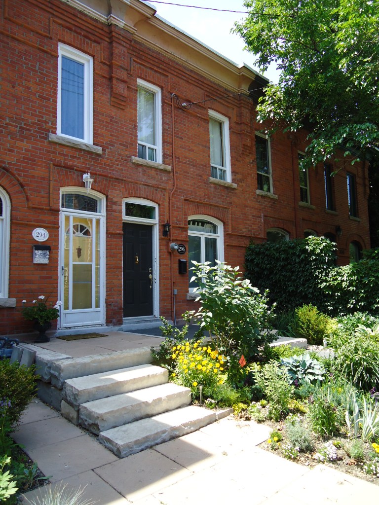
In February 1888 the City of Toronto decided to build a sewer from Natalie to Paisley (Jemima) on Booth. By May of 1888, construction of the Russell Terrace on Logan, Natalie and Booth was under way. “There are upwards of 100 houses now under construction on the lots we have already sold” (Globe 24 May 1888) These were free-hold properties.

Here are a details from Goad’s Atlas plan from 1884 showing the crossing and the neighbours Thomas Mitchell (poultry dealer), John Logan (market gardener), Daniel Brook (absentee landowner and merchant), and John Russell (brick manufacturer).
The H-shaped wooden (yellow) building on Logan’s farm is likely a greenhouse. Ambrose Rudd was also a market gardener and those are very probably greenhouses as well.
A. RUDD is a native of Devonshire, England, where he was born in 1833. In 1853 he emigrated to Canada, and took up his residence in Quebec, where he stayed two years, afterwards coming to Toronto and entering into the employment of the Bank of Upper Canada. He remained two years at the bank, and then settled on what is now Logan’s Lane, where he acquired nine acres of land, and commenced the gardening business, in which he has been successfully engaged for over twenty-eight years. In 1828 he married Miss Elizabeth Tulford, of Cumberland, England, the marriage being productive of only one child, a daughter. ( Mercer Adam, History of Toronto and County of York, 1885, vol. II, p. 203)
Like Ambrose Rudd, Thomas Mitchell has a brick house (red) as well as a barn for his chickens. He may have got the bricks to build his house from his near neighbour across the tracks John Russell.
THOMAS MITCHELL is a native of Devonshire, England, where he was born in 1822, and emigrating to Canada in 1849, located first in London, Middlesex County, where he was employed by Judge Allen. The Judge removing to Toronto after Mr. Mitchell had been in his service six months, he removed with him and continued in his employment for three years. He subsequently engaged with Mr. John Cull, as foreman in the Starch Factory, with whom he remained eight years. He then began business for himself as grocer on Kingston Road, and built the first brick store east of the Don (1858). This was on the corner of Kingston Road and Scadding Street, and was known as “Mitchell’s Corner”. In 1861 he purchased a lot on Market Square, Barrie, Ontario, and built thereon the Victoria Hotel, which he afterwards sold. In 1871 Mr. Mitchell retired from business which is now carried on by his son. He purchased a private residence known as Rose Lawn, in St. Matthew’s Ward, where he now lives in ease and comfort. Mr. Mitchell married in 1852 Miss Mary Ann Joslin, of Devonshire, England, by whom he has one son and four daughters. Once only since leaving it has Mr. Mitchell revisited his beautiful native county which, with pardonable pride, he maintains is the “Garden of the World”. This trip he made in 1874. (Mercer Adam, History of Toronto and County of York, 1885, vol. II, p. 201)
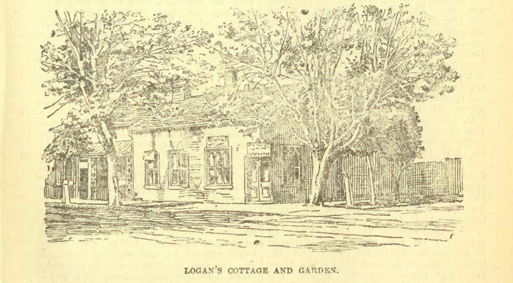
Leslieville gardener, John Logan, (Logan Avenue is named after his family) was active in the City of Toronto Horticultural Society After John Logan Sr. died, his wife Elizabeth (1828-?) continued the market gardening business with the help of daughter Annie and sons William, George and John who became a brick manufacturer on Greenwood Avenue. They also owned a cottage downtown which Elizabeth operated as a store, selling their produce. John Logan, a tall shy man, preferred to look after the gardening, leaving his wife to handle the customers. John Ross Robertson describes the Logans in his Landmarks, Vol. 1, p. 126-127. What he doesn’t mention is that John Logan was instrumental in making Leslieville a welcoming place for refugees from slavery.


John Russell (1838-1912) was probably the first to introduce new kiln technology to Leslieville. In 1894, he built a continuously-feeding kiln that could burn all year around, abolishing the brickmaker’s season. However, periodic or ‘beehive” kilns would continue to be used in Leslieville as well as the downdraft rectangular kilns The new kilns were more energy-efficient, but were not cheap, like scoved kilns. John Russell used 150,000 bricks to build the foundation for his kiln. Leslieville’s traditional brickmaking families passed down their knowledge from father to son (and from mother to daughter). They may not have welcomed innovations, but to compete with outsiders if not each other, they had to adopt new ways. Russell also was a contractor, building many houses in the neighbourhood, including the terraces on Logan Avenue and Booth Avenue. He was also a City of Toronto alderman and was characterized as a Sphinx because he rarely said a word.
John Russell married Mary Smith. They had ten children: nine girls and one boy. Their son, Joseph (1868-1925) was the brick manufacturer, politician and dog fancier who ran the brickyard where Alton, Hiltz, Dorothy, Parkfield, Stanton, and Sawden are today. The death of John Russell in 1912 triggered the sale of the brickyard at Greenwood and Queen. Real estate had to be liquidated in order to divide the Estate amongst his ten children.

Most of the Russell land was clay pit. The largest brick house on Kingston Road (now Queen Street East) was his home and the wooden buildings around it were brick kilns, drying sheds and outbuildings for his business. Value Village is there now.

Street names have changed and it can be, and is, in this case, confusing. Natalie was Melford. Booth was Bangor. Jemima is now Paisley. Logan was Fitzroy, Blong, and Sewell’s Lane.


This is a fascinating account and I enjoy your annotations of the old photographs. Interestingly enough, we have a Dundas Street in our town (Grahamstown) in the Eastern Cape of South Africa. It was named after Major-General Francis Dundas, a Landdrost (magistrate) of the town from 1825 to 1828.