What happened? How can a street be lost?
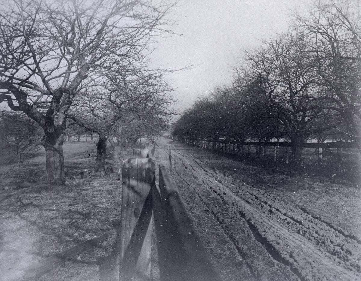
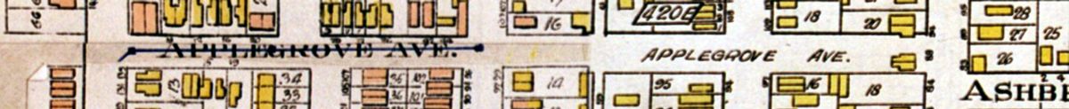
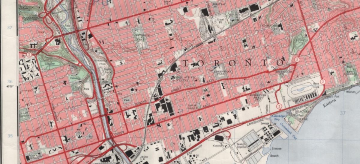
 Let’s go back to the beginning, around 1909 when Applegrove Avenue was a short street running from Morley Avenue, now Woodfield Road, to Ashdale Avenue — a mere two blocks. It ran through the Ashbridge’s large apple orchard, giving an obvious reason for the street name. Applegrove Avenue was 910 feet north of Queen Street East. A large brickyard lay between the west end of Applegrove Avenue and Greenwood Avenue. It did not extend to Coxwell in the east.
In 1910 the City Engineer that one of the short streets running off of Applegrove be extended down to Queen Street. Ashdale Avenue south of Gerrard was just a short muddy track that dead-ended about 200 feet north of Queen. It ran north from Gerrard past over a level crossing at the railway tracks all the way to Danforth Avenue.
The City Beautiful movement and the birth of the profession of town planning spurred the development of imaginative plans to remodel Toronto into an ideal city with broad avenues, not the narrow, crowded streets. Instead of a grid plan, diagonal avenues would link suburbs encircled by a boulevard like a ring around Toronto. It was a grand, even grandiose, vision that included a rapid transit that included parkways and a subway, Metropolitan Toronto government, and even the preservation of Toronto’s ravines as parkland. The Toronto Harbor Commission’s plan to fill in Ashbridge’s Bay, extend the Toronto Harbor shoreline south, and build Lakeshore Boulevard was incorporated into this larger vision, known as “the Boulevard Scheme”. Some versions of the plan had Lakeshore Boulevard crossing the Western Gap, over the Toronto Islands and the Eastern Gap, along the new industrial area, now known as “The Portlands” and through the Beach at the waterfront, to terminate at Victoria Park. This would be a world in which the car was king and the city severed from the lake by a super highway.
Work would start first on the southern section of the boulevard schem, beginning with the Humber route. The plan called for a boulevard along the waterfront to Victoria Park, which would be expropriated to make way for the highway.
Part of the plan included:
Widen and extend Wilton avenue from the bridge to Kingston road, via Elliott, Whitby and Audley streets and Doel avenue.
In 1912 the City Engineer recommended that the city extend Applegrove Avenue from Ashdale east to Coxwell at a width of 66 feet. At that time those living on a street where expected to pay most of the cost of extending or improving a street. The City Assessment Commissioner worked hand in hand with the City Engineer, adding a proportion of the cost to each homeowner’s annual property taxes, in this case spread over ten years. However, there were only ten families living on Applegrove in 1912. It was not the most desirable location. The noise and smoke from the brickyard would have been constant as brick kilns burned day and night. The City tried to foist 70% of the costs on those living on Applegrove and on neighboring streets like Rhodes Avenue, Coxwell, Ashdale, Erie Terrace (Craven Road). Needless to say there was an uproar even though the City’s notice advising of the plan warned:
A petition against the said proposed work will not avail to prevent the carrying out of this improvement. Toronto Star, October, 1912
But the City backed off this smaller project as city politicians felt the heat from East End voters.
The larger project, the Wilton Avenue extension, was projected to cost $800,000, including $200,000 for an underpass near Logan Avenue. Wilton Avenue was the forerunner of Dundas Street East, running along the same route to Coxwell Avenue, swallowing up smaller streets like Dagmar and Doel and, ultimately, Applegrove. To put this in perspective, a skilled tradesman, such as a carpenter, in Toronto made about $800 a year and a factory worker about $400 a year. The City of Toronto would pay 81 percent of the cost of extending Wilton Avenue; homeowners along the route would pay the rest of the amount through a levy included on their property taxes. Here is the description of the route as discussed at a Parks Committee meeting:
Wilton Avenue Extension
The proposed expenditures also includes the widening and improving of Whitby street to a width of 66 feet, and its extension easterly to Logan avenue; the diversion of Logan avenue to the west side of the Grand Trunk Railway tracks at a width of 66 feet; the extension of Dickens avenue, 66 feet wide to Pape avenue; the opening of a 35-foot thoroughfare from the rear of lot 55 on Pape avenue to Jones avenue, which thoroughfare is intended to take the location now used by the high-level sewer right of way; the extension of Doel avenue, 66 feet wide, and its diversion in a south-easterly direction following the course of the trunk sewer to Morley avenue; and the extension of Applegrove avenue, 66 feet wide to Coxwell avenue, as a local improvement, under section nine of the Local Improvement Act. (Toronto Star, July 15, 1913)
The City Board of Works pushed for immediate action on the Wilton Street extension, arguing that the project was necessary and waiting would only drive up the cost: “the circumstances require immediate action. (Globe, September 20, 1913). But the economy swung into a brief recession just before World War One and the City complained that “money is had to get”. City Commissioner of Works R.C. Harris found his budget gutted, as the City Treasurer explained the financial realities.
In early August, 1914, World War One began, but virtually everyone expected it to be over by Christmas. Harris continued to fight for the building of what is now Dundas Street East:
The recommendation dealing with the extension of Wilton avenue in the Riverdale district was referred back to the next meeting of the committee…
As outlined in his report, which supersedes all previous recommendations, Commissioner Harris combines the widening of Wilton avenue as far as Logan avenue, the construction of a subway under the G.T.R. tracks and the extension of Dickens avenue. A new street is to be opened, following the right-of-way of the trunk sewer from Dagmar to Jones avenues, while Doel and Applegrove avenues are also to be extended. (Globe, October 10, 1914)
The grand project was shelved on the outbreak of World War One in 1914 as the war effort shifted priorities. This part of the grand plan would not be realized until 45 years, two World Wars, a Great Depression and the dominance of the automobile radically changed Canada’s cities.
Even as the war in the trenches raged on, Harris continued to push for, at the very least, the extension of Applegrove eastward to Coxwell.
The Works Commissioner has recommended the extension of Applegrove avenue from Ashdale avenue easterly to Coxwell avenue. The estimated cost of the improvement is $27,000, of which the city will contribute $7,168. Globe, October 16, 1910
This time the City meant business and notified homeowners in Toronto newspapers:
LOCAL IMPROVEMENT NOTICE
APPLEGROVE AVENUE EXTENSION
Take notice that the Council of the Corporation of the City of Toronto intends to extend Applegrove Avenue at a width of 66 feet from Ashdale Avenue easterly to Coxwell Avenue, and intends to specially assess a part of the cost upon the land abutting directly on the said work, and upon certain other lands hereinafter mentioned, which will be immediately benefited by such extension. The estimated cost of the work is $17,000, of which 26 53-100 percent [26.53%], or $7,163 is to be paid by the Corporation. The remaining 73 47-100 percent [73.47%], or $19,837, is to be assessed against the property fronting or abutting on the following named streets…
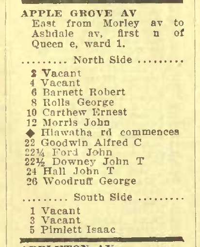
The streets included Applegrove Avenue, Ashdale Avenue, Coxwell Avenue, Erie Terrace, Hiawatha Road, Morley Avenue, Kent Road and Rhodes Avenue. Those living on the street would benefit by improved access to their property on a better wider street, as well as by higher property values. The extension would open up the area to the housing boom that was expected after the War ended and which actually began in 1923. Of course, the building of a 66-wide through the East End was still part of a greater master plan to re-engineer Toronto’s road network to meet the demands of the automobile and the growing suburbs around the center of the city.
Local residents, championed by City Councillor Robbins (Robbins Avenue is named for him), protested both against the extension and paying for it, arguing that there was no traffic anyway and that it was unfair to ask the wives of so many serving soldiers to pay. Recruitment from the neighbourhood was, with the Earlscourt community, the highest of any city in Canada. City Council, while not abandoning its plan to extend Applegrove east to Coxwell, did back off its plan to force local residents to pay heavily for the project. However, when the Applegrove extension appeared before the Works Committee in May, 1918, the Committee recommended that the project be shelved.
In August, 1919, City Council passed another by-law raising $249,000 “to discharge indebtedness created to extend Terauley street and Applegrove avenue”. (Globe, August 21, 1919)
In 1924 another notice appeared in Toronto newspapers, identical to that of 1917, but by this time perhaps Council thought that since the area was in the midst of a housing boom, the benefits of the extension would be more tangible and a walloping tax more acceptable.
LOCAL IMPROVEMENT NOTICE
APPLEGROVE AVENUE EXTENSION
Take notice that the Council of the Corporation of the City of Toronto intends to extend Applegrove Avenue at a width of 66 feet from Ashdale Avenue easterly to Coxwell Avenue, and intends to specially assess a part of the cost upon the land abutting directly on the said work, and upon certain other lands hereinafter mentioned, which will be immediately benefited by such extension. The estimated cost of the work is $17,000, of which 26 53-100 percent [26.53%], or $7,163 is to be paid by the Corporation. The remaining 73 47-100 percent [73.47%], or $19,837, is to be assessed against the property fronting or abutting on the following named streets…
Memories were short, but not that short. Property owners were again enraged as the prospect of paying three-quarters of the cost loomed over them. Shortly after another notice appeared with the figures adjusted to make the tax far more palatable and spread out over a decade.
LOCAL IMPROVEMENT NOTICE
Applegrove Avenue Extension
Take notice that the Council of the Corporation of the City of Toronto intends to extend and grade Applegrove Avenue, at a width of 66 feet, from Ashdale Avenue easterly to Coxwell Avenue, as a local improvement.
The estimated cost of the work is $27,300,00 of which 50 per cent, or $13,650.00, is to be paid by the Corporation.
The Council further intends to specially assess the sum of $13,650.00 against the property abutting upon the proposed improvement, and other property which is specially benefited by the proposed work.
The special assessment is to be paid in 10 annual installments.
For a short extension, the decision to actually move forward was a long and winding road. Two years later, in 1926, Applegrove still didn’t reach Coxwell and City officials were still promoting it:
Regarding a suggestion of Ald. Baker, Assessment Commissioner Forman and Works Commissioner Harris expressed in a letter the opinion that Applegrove avenue should be extended from Ashdale avenue, easterly to Coxwell, as per their report of 1924, estimating the cost at $27,300, and fixing the city’s share of the cost at 50 per cent. (Toronto Star, October 8, 1926)
In 1929 Applegrove still didn’t reach Coxwell.

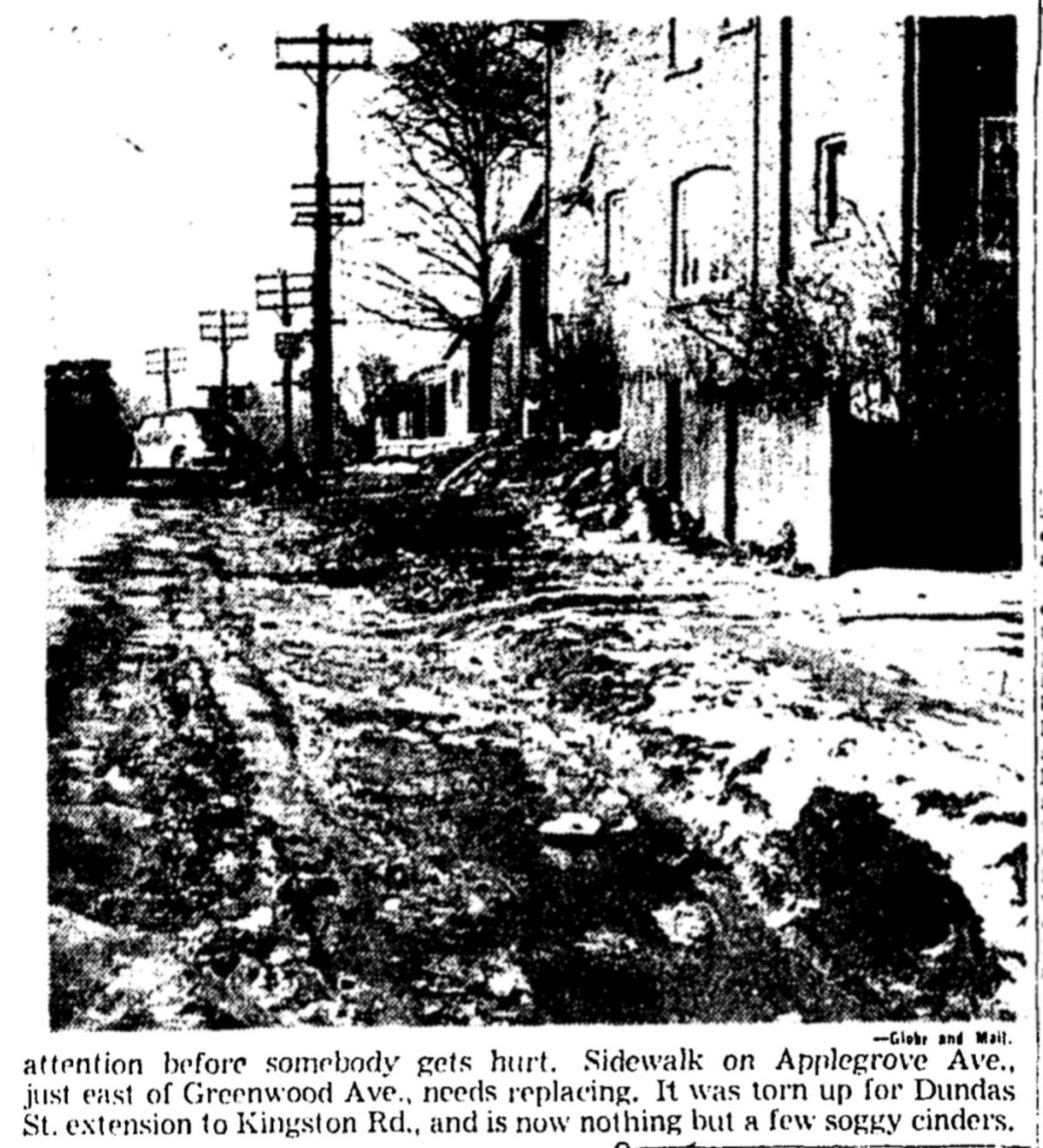
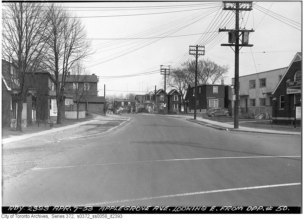
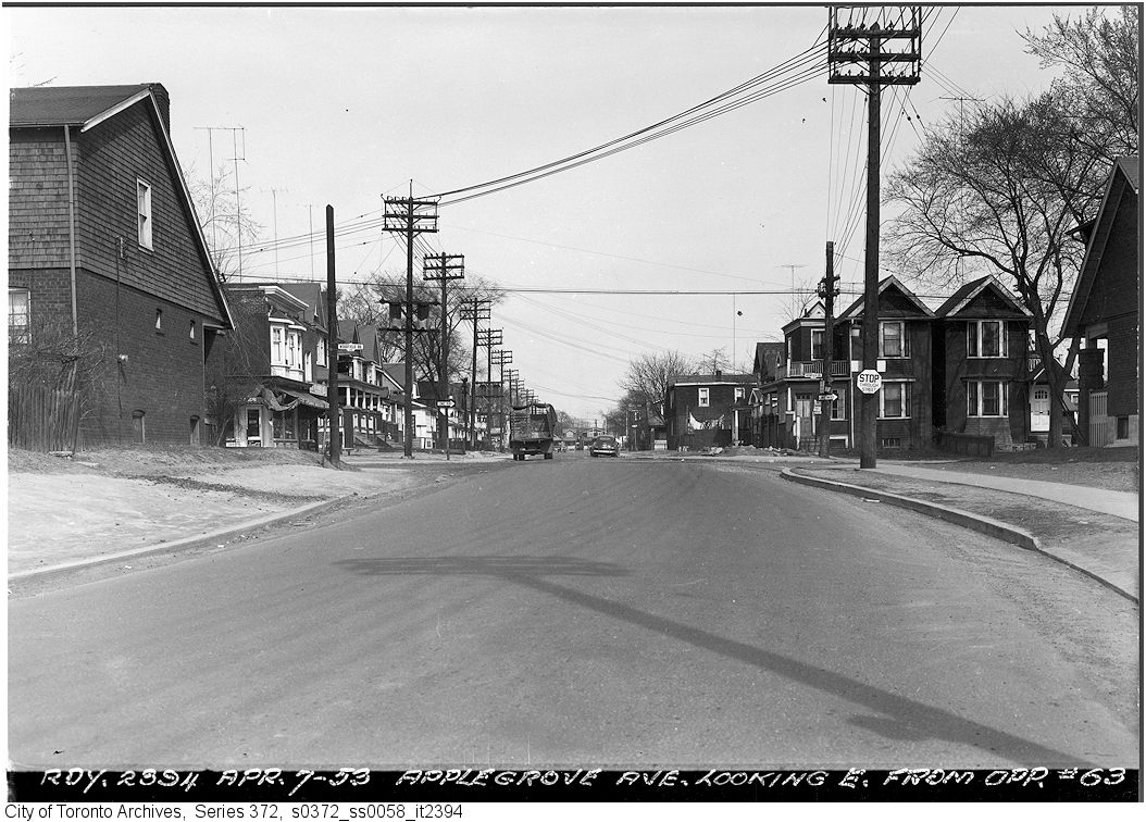
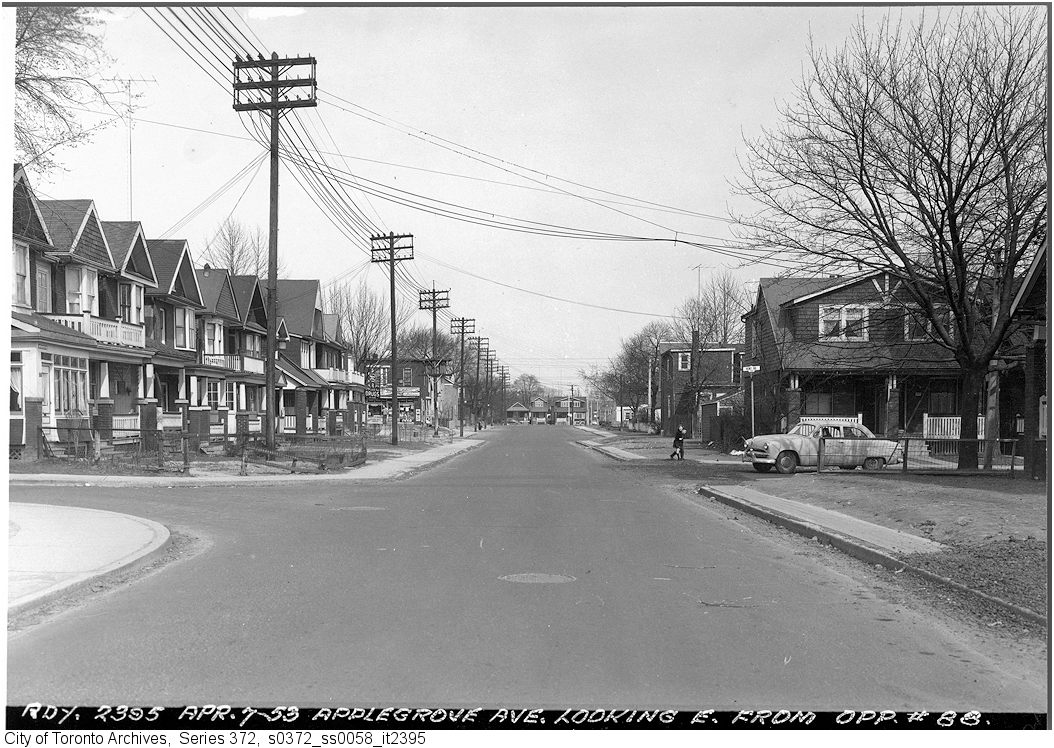
In February 1930, it was decided not to renumber Applegrove Avenue to reflect the new houses on the street and the extension west to Greenwood. Why? “because it was expected that before long the street would be part of Dundas St. to be extended through to Kingston Rd.” (Toronto Star, February 25, 1930) But the City had not counted on the Great Depression lasting another nine years or the Second World War that finally brought full unemployment and a housing crisis to the East End. Dundas Street East would have to wait, but meanwhile the Applegrove extension still hung pending.
And in early 1934 it still didn’t reach Coxwell.
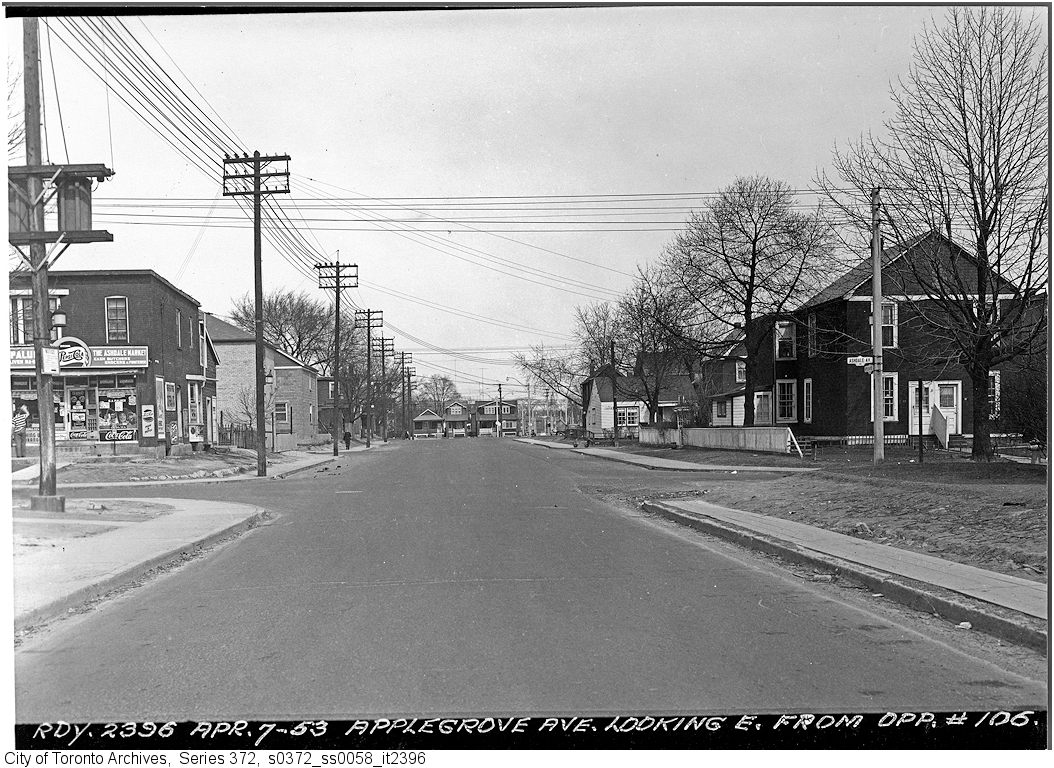
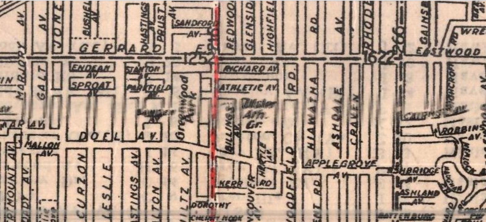
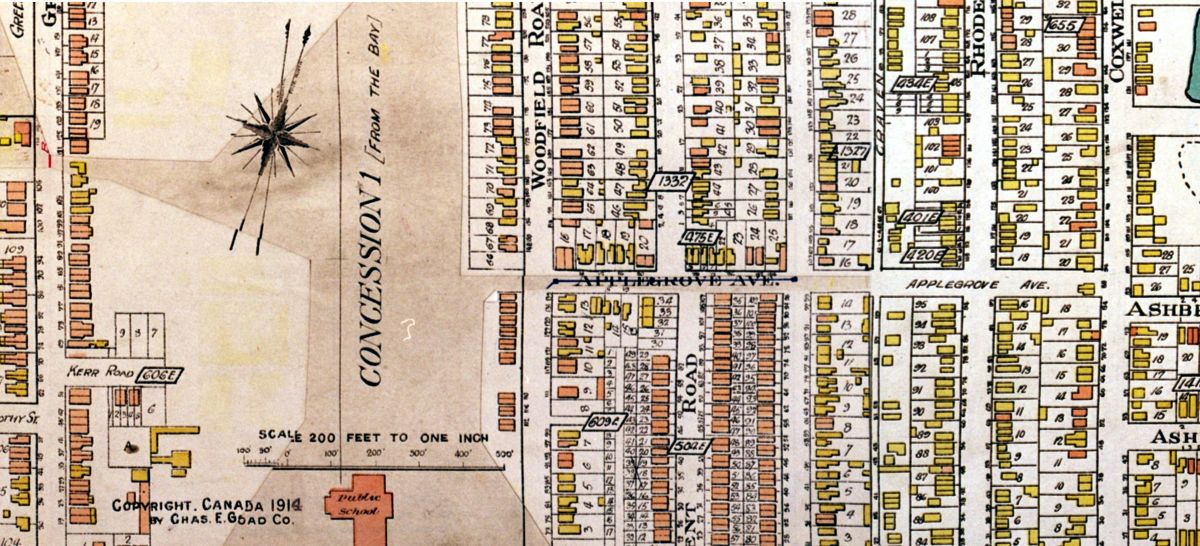
But it was extended finally later in 1934 as this map of Toronto shows.
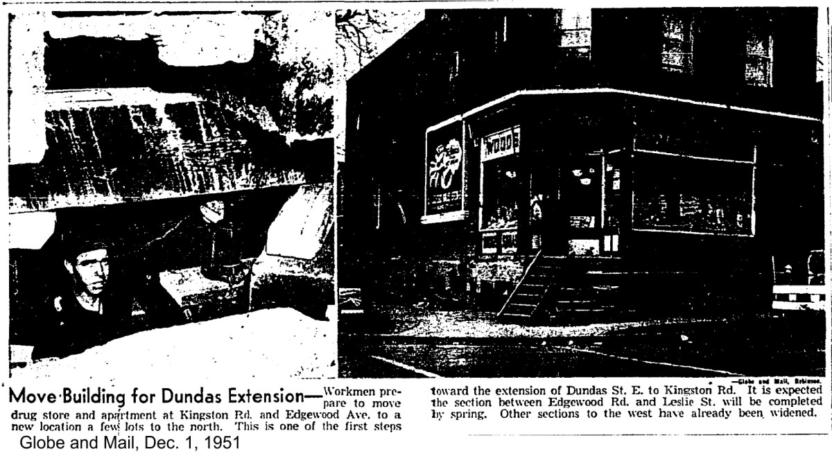
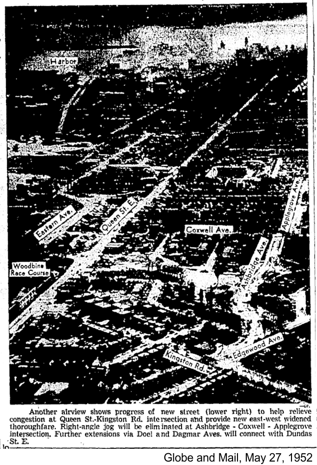
After the end of World War Two, the creation of Dundas Street East through to Kingston Road was back on the table as traffic jammed Queen Street East, Eastern Avenue and Gerrard Street. Another through street across the East End would be a major route in the days before the Don Valley Parkway and the 401 Highway.
17 HOMES TO GO
START EXTENDING DUNDAS IN EAST
Seventeen east Toronto homes will be expropriated and demolished as soon as possible to speed up the start on the Dundas St. extension, board of control decided today.
A delegation of east-end residents, headed by James Arnott, urged the city to start work on that section of the new extension between Coxwell Ave. and Kingston Rd. in order to alleviate traffic congestion at the Eastern Ave – Queen St. bottleneck.
The board gave Leslie Allan, deputy works commissioner, authority to press on with the work. The municipal board [OMB] will be asked to expedite its approval of the project which R.C. Baird, legal counsel, [said] had been delayed because of a last-minute change in the route.
The homes which will come down are situated on Edgewood Ave., Maughan Cres. and Coxwell Ave. the eastern section of the roadway will follow Ashbridge Ave. to Maughan Cres. where it will follow the southern curve of the crescent across the Serpentine ravine to Edgewood Ave. and Kingston Rd.
Mr. Allan promised an immediate start on the filling of the ravine. Watermains will go in as soon as the homes are down, he added, with the hope this work will be completed by next spring and the paving to follow shortly after. It is expected that the complete length of the new extension will not be open until 1954 or 1955. Toronto Star, June 7, 1950
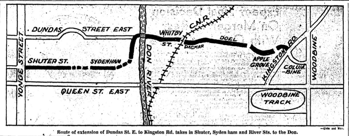
City Council approved the route extension and a budget of $3,242,305 to complete the work. The new Dundas Street East followed Whitby Street, Dagmar, Doel, and Applegrove across Coxwell to Maughan Cres. From the corner of Maughan Crescent and Orchard Park Road, it went a little southeast then curving northeast to meet Kingston Road near the western boundary of St. John of Norway Cemetery.
According to the Globe and Mail,
The extension is seen as much-needed relief for easterly traffic along Keating st., now carrying a capacity traffic load during rush hours [Lakeshore Blvd. had not yet been built in the East End]. The Toronto Planning Board believes it will provide an important direct connection between the downtown area and the east end of the city.
The extension will be diverted southerly as it passes under the CNR tracks to allow construction of a subway just west of Logan Ave. Globe and Mail, June 8, 1950
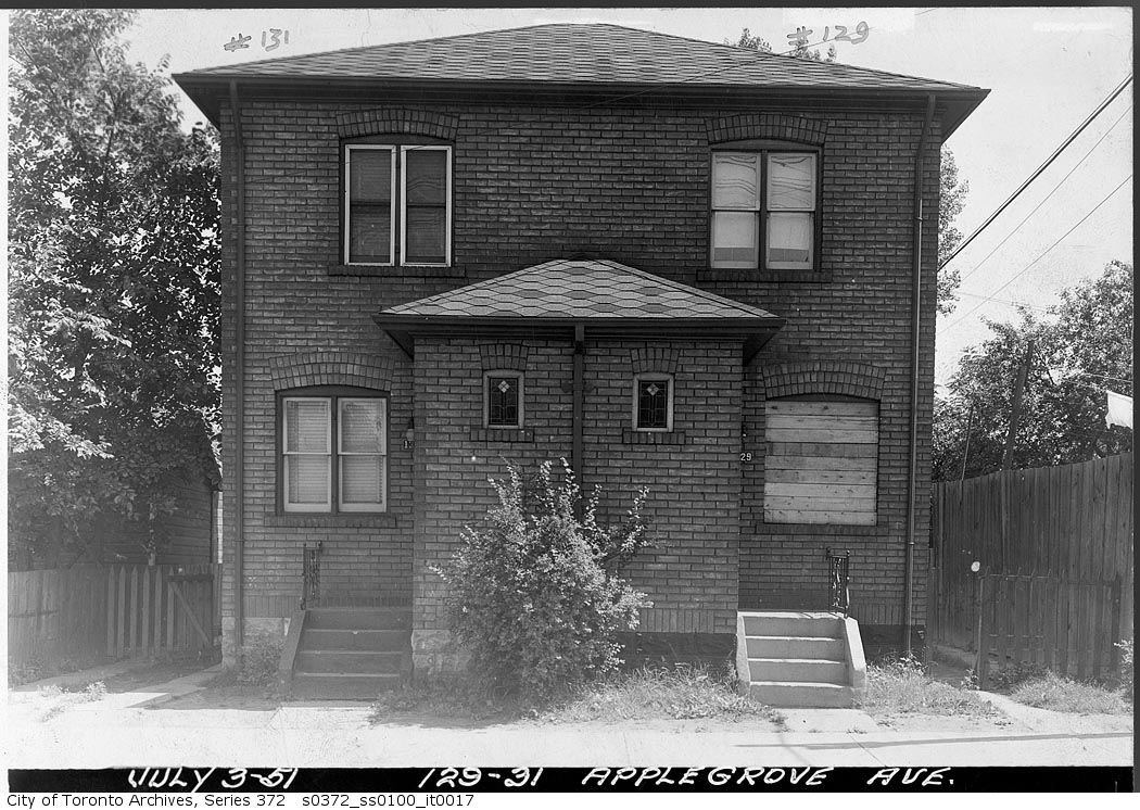
The construction work would begin at the eastern section where it connected with Kingston Road. This is the area where 17 houses would be torn down, including three houses at the southeast corner of Applegrove and Coxwell and others on Maughan and Edgewood. Not everyone was behind the new Dundas Street route. James McIlmurray had just finished work on his triplex on Kingston Road – one of the houses on the tear-down list:
“We’re upset, very upset,” said Mr. McIlmurray, reflecting the attitude of his neighbors…We got the building permit two months ago…They told us then the extension would go up the ravine. So we bought radiators, window casings and lumber.” (Toronto Star, June 8, 1950)
A week later the Ontario Municipal Board approved the project. Council decided that it didn’t need to submit the project to voters for approval. Alderman Collins said, “This means the green light.” (Globe and Mail, June 15, 1950). On June 26, 1950, City Council approved a bylaw allowing the Dundas Street extension project to go ahead.
The next day The Globe and Mail reported,
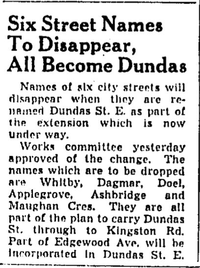
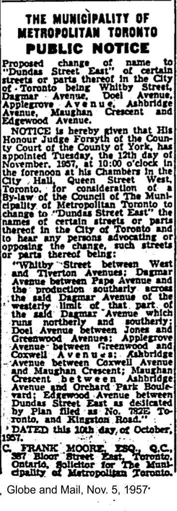
To Change Names of Four Streets
Without moving, residents of four streets in Toronto’s east end will undergo a change of address when the Dundas St. E. extension is completed.
City council last night endorsed a recommendation by Planning Commissioner LeMay that Dagmar, Doel, Applegrove and Ashbridge Aves., which will be part of the extension, be changed to Dundas St. when the work is completed. (Globe and Mail, June 27, 1950)