

This is a short street, broken into two sections one south of Dundas Street East and the other a shorter section running south off Gerrard Street. It has an interesting history as it was the focus of a long-running law suite brought by John Russell against the City of Toronto which had seized the property along Carlaw Avenue for non-payment of property taxes. Russell fought the City all the way through Canada’s court system to the Privy Council in London, England. He lost, but the lawsuit delayed the building of necessary infrastructure on only one street — Boston Avenue, which in the early days did not have City water or sewers. To protect its plant, the Wrigley gum company built its own fire hall at 87 Boston Avenue, a lovely and unique building that stands today, restored.

Shaw’s Inn was a roadside hotel catering to those travelling Queen Street, then known as Kingston Road. The man holding the horses was a refugee from slavery, a horse whisperer known as Lewis “Doc” Docherty. There was a toll gate at Leslie and Queen and another at Broadview and Queen. Shaw’s Hotel gave teamsters a chance to water their horses and “wet their own whistles” or stay for the night and rest the teams before heading downtown or eastwards. This image was drawn by F. H. Granger in 1849.

Boston Avenue Development Timeline
1905 Deed of Land of Lot 36B on the west side of Boston Ave., Plan 40E. City of Toronto to John Church, May 12, 1905
1909 Dovercourt Land ad, developed Boston Avenue in 1909, Globe, June 20, 1914
1909 Boston Avenue graded from Queen street to appoint 1,381 feet north. Grading Boston Ave., Globe July 21, 1909
1910 The City of Toronto decided “to make an extension of Boston avenue, connecting two sections by about 700 feet of road. The cost will be about $422,000, and the city is to pay half.” Globe Oct 15 1910
1911 The Court of Revision yesterday approved the extension of Boston Avenue. Globe, Jan 18, 1911. But the extension connecting the two sections of the street never was realized because by that time factories had occupied the lands between the two parts of the street.


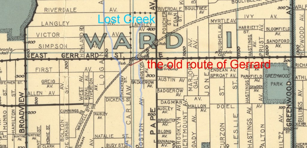
This map shows Heward Creek, also known as Holly Creek. Two branches of Heward Creek met just north of the corner of Pape Avenue and Queen Street. The west branch flowed down from near Hogarth Avenue and Broadview, crossing Gerrard where the fire hall is today, and running south, just west of Carlaw Avenue. It crossed Carlaw where the Printing House Lofts are today and met the east branch of the creek. The east branch ran down from springs just of Gerrard where Metrolink is building a station today. It crossed Gerrard where the LLBO store is, ran under a buried bridge on Badgerow Avenue, and down the west side of Boston Avenue. The Wrigley Gum factory dammed this small brook in winter to create a skating rink.


I want o tell you how much I appreciate these notices. I signed up a
couple of years ago (I think) because you did an article about Rolph
Clark Stone where my mother worked as a greeting card artist. Got the
next few and then it all stopped. Curiosity compels me to ask how I got
back on the mailing list? Thanks, Crazy John (an 81yr old man now from
Brockville Ontario)
Hi John, thank you for your kind words. I apologize for the delay in my response. How cool that your mother worked at Rolph Clark Stone! You can subscribe to this website and be notified of any posts. You can also go to the Leslieville Historical Society Facebook group and search for Rolph Clark Stone. You will find a lot of posts there.
Take care,
Joanne