
By Joanne Doucette
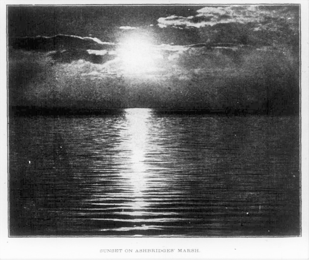
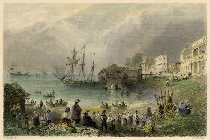
What we have now, a small body of very polluted water at the base of Coxwell Avenue, is not what Ashbridge’s Bay once was or could be again–with imagination, investment and time. And time is what today’s post is all about. It is a very detailed timeline of Ashbridge’s Bay. Take your time when reading it, go slow, a bit at a time, and go there in your mind’s eye. The first picture here is from January 26, 1913.
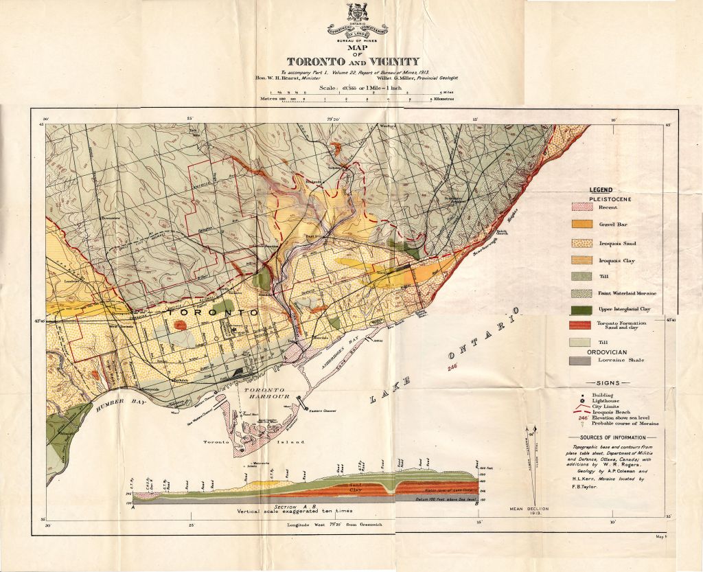
12000 Before Present The lands occupied presently by the Lower Don and the Port Industrial District were drowned by high water levels in the Ontario basin during post-glacial Lake Iroquois. When the last glacier of the last ice age melted, it formed Lake Iroquois in the basin of what is now Lake Ontario. This post-glacial lake was 55 metres higher than the current Lake Ontario. Where the ancestor of the Don River poured into Lake Iroquois, the action of the waves and the strong westward offshore current carried sediment along, depositing it as a “baymouth bar” with a backshore lagoon later called Ashbridge’s Bay.[1]

The building of the sand spit continued to the late 20th Century. Currents, mass movements of water from place to place in lake or ocean, are present at almost all depths. The Niagara Current runs west along the north shore of Lake Ontario. This strong longshore current flows westward along the north shore of Lake Ontario. The shores of Lake Ontario about Toronto are low except on the east, at Scarborough (nine miles from the centre of the city), where the land rises to 324 feet above the lake, and forms precipitous cliffs along the shore for some distance. Highland Creek and the Rouge River flow into the lake east of this point. [2]
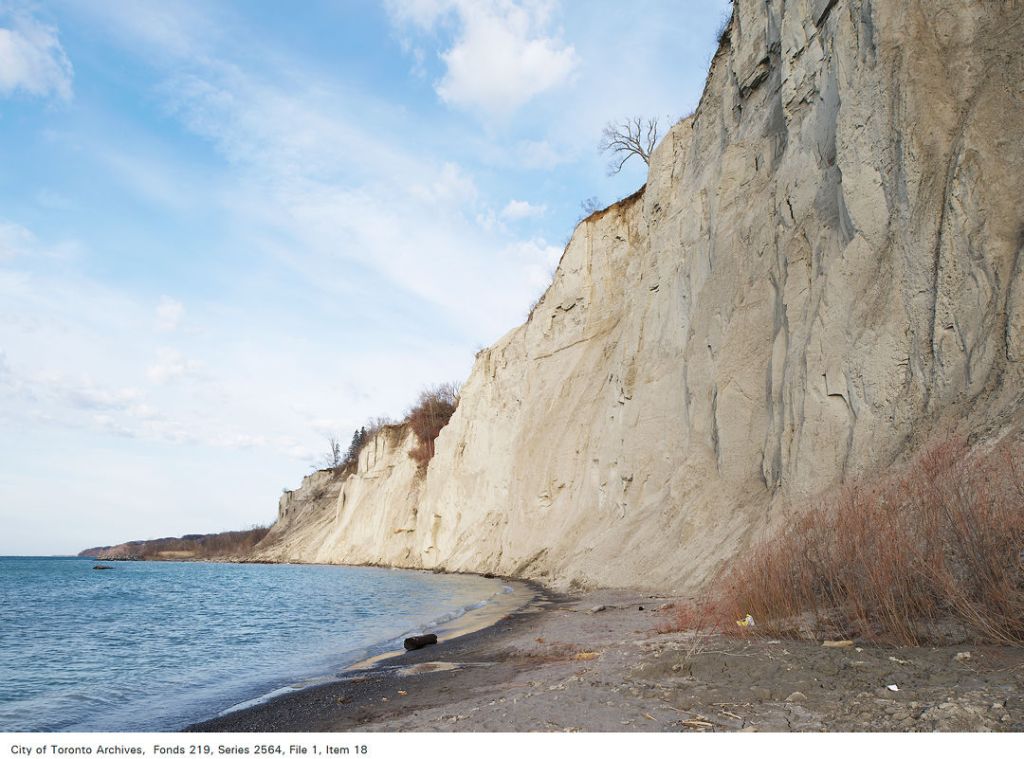
As waves crash on the shore, as they do at the Scarborough Bluffs, continual strong wave action erodes material away. The backwash from the waves removes sediment and the current moves it along the shore until it reaches a spot where the energy of the water is too low to let it be carried further. “If the coast is reasonably straight and there is a persistent current from one direction, large amounts of sediment can be delivered down the coast. Surface currents which move parallel to a shore are longshore currents.” [3]

When waves have very little energy, they deposit sediments and that is why the long finger-like peninsula, with its pattern of ridges and troughs, developed. Where a coastline is indented, as Toronto Bay is, it is a sheltered area. Sand, eroded from the exposed Bluffs, was deposited on the shore of this sheltered bay, initially forming a small pocket beach, along the inner shores of the harbour. The current eventually spread sand out across the mouth of the bay from east to west forming a spit. A series of offshore bars, in a peak and trough pattern, lie offshore. [4]
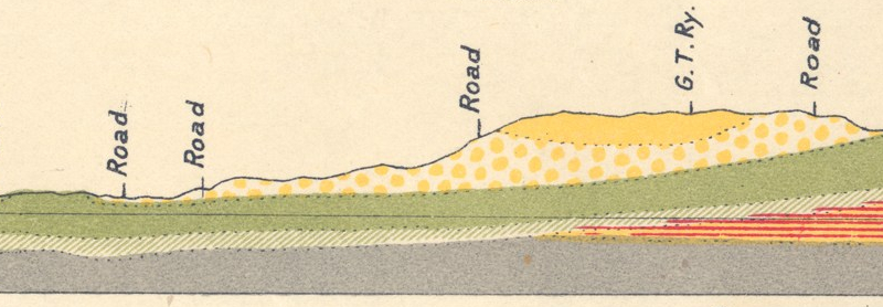
Lake Ontario current carried Scarborough Bluff deposits westward until the current slowed and it was deposited in a series of continuously moving sand-bars, or littoral drift deposits. A series of continuously moving sand-bars, or littoral drift deposits, eventually ran from Woodbine Avenue to Gibraltar Point. By the early 1800s, the longest of the sand bars reached almost nine kilometres south-west from Woodbine Avenue. The sandbar went through Ashbridge’s Bay and Lower Don marshes, creating natural harbour between lake and mainland. Offshore, the lake bed steeply drops off at the shore cliff of ancient Lake Admiralty. This is known as “the Toronto Scarp”. This drowned lakeshore runs parallel to the Beach and the Toronto Islands. Here upwelling currents carry food, attracting shoals of fish.
A backshore lagoon, called “Ashbridge’s Bay”, lay between the sand bank and the higher ground north of it. The marsh was a maze of channels connecting ponds with areas of open water. The marsh was 520-hectare or 1,285 acres. Countless migratory wildfowl fed here. It was a mosaic of large and small ponds with lagoons, bogs and islands of cattails, water lilies, arrowhead, grasses and duck weeds in the sloughs between the dunes. Nutrients from the Don created habitat for frogs, turtles:
This is really a marshy lagoon of considerable size, and though filled in, in places, still affords food and shelter for many species of birds. Into this bay originally drained some eleven creeks, and at its western end the River Don, which now is confined to an artificial channel and flows into Toronto Bay somewhat further north than where the original outlet of Ashbridge’s Bay was. [5] Though mere brooks in the Twentieth Century when they were buried to become part of Toronto’s storm sewer system, they were much bigger in earlier days: “It must be remembered in connection with the use of these rivers, and others even smaller, than the streams of today have much less water than they had in the days of the fur trade and early settlement. The clearing of the forests has led to the quick evaporation and drainage of the surface water, and many a noble river has shrunk to a mere creek, with insufficient depth to float a boat except in the season of spring floods.[6]
Between Jones and Coxwell Hastings Creek and Ashbridge’s Creek emptied into the Bay.
- Heward Creek flowed from near Broadview to enter Ashbridge’s Bay near Pape Ave.
- A creek (Leslie Creek) flowed down from where Gerrard Square is now, to cross Jones Avenue just north of Queen. One branch of this creek was dammed it in the late nineteenth century to form Maple Leaf Skating Rink at Pape and Gerrard, behind the Maple Leaf Tavern. Leslie Creek cut across Leslie Grove, the George Leslie farm, to join with Hastings Creek and enter the Bay near Leslie and Eastern Avenue, cutting a small cove, called “the Gut”, into the shoreline.
- A creek (Hastings Creek) crossed the Danforth just east of Jones and cut a deep ravine where Ravina Crescent is, and south of the railway tracks between Jones and Greenwood, north of Gerrard. It cut a deep Ravine where Ravina Crescent is, flowing south through Thomas Hastings’ farm to enter the Bay between Leslie Street and Laing, west of where the Maple Cottage is now.[7] These creeks cut some deep ravines. One of the deepest was the “Devil’s Hollow”, cut by by this from Gerrard Street north to the railway tracks, between Prust Avenue and Leslie Street. This ravine like many others was virtually eliminated through the dumping of landfill, including garbage.[8]
- The western branch of Ashbridge’s Creek flowed all the way down from Sammon to join the eastern branch and flow through the Ashbridge’s Farm to cross Queen Street near the Ashbridge’s House. Glenside (formerly Glencoe) is over top of the western branch Ashbridge’s Creek — the other branch of the Creek ran up Woodfield Road and stretched north of the Grand Trunk Railway line. The branches met south of Gerrard to flow into the lake east of Greenwood Avenue where the TTC’s Russell Carhouse is today. [9]
- The Serpentine, Small’s Creek or Woodbine Creek also had two branches. The west began just east of Coxwell. It carved a ravine just north of Kingston Road (still there and the creek runs above ground). A branch of Small’s Creek flowed down from above Danforth Avenue through Lynn Park past Merrill Bridge and continued south to empty into a holding pond by the railway tracks. The steam-driven locomotives used water from the stream to fill their tanks. The eastern branch known as Norway Creek or Tomlin Creek, cut a deep ravine north of St. John of Norway Church and formed a large pond (Small’s Pond) where it was dammed to power a sawmill.
- Several other small streams flowed into the bay in this area as well.
1759 Around 1759, French soldier Pierre Pouchot described what is now known as Ashbridge’s Bay: “a point of land, wooded and forming a peninsula and in the rear a large bay partly covered with rushes.”[10]
1787 the British Crown had purchased land following the canoe portage from Lake Ontario to Georgian Bay from the Mississauga and Chippewa or Ojibway peoples. Lord Dorchester, Sir Guy Carleton, arranged the Toronto Purchase as governor-in-chief of Canada.
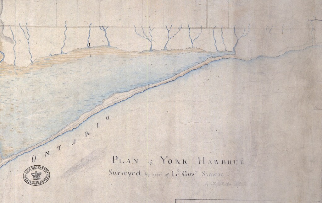
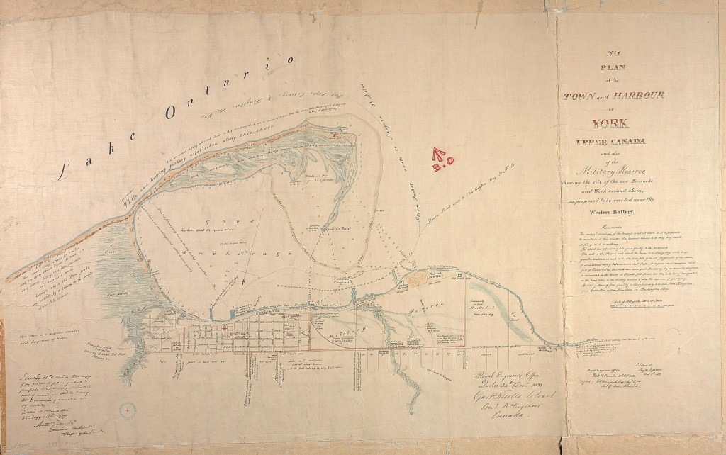
1788 Deputy Surveyor General J. Collins: …near two miles in length from the entrance to the isthmus between it and a large morass to the eastward. The breadth of the entrance is about half a mile, but the navigable channel for vessels is only about 500 yards, having from 3 to 3 1/2 fathoms water. The north or main shore the whole length of the harbor is a clay bank, from 12 to 20 feet high, and gradually rising behind, apparently good land and fit for settlement. The water is rather shoal near the shore, having but one fathom of depth at 100 yards distance, two fathoms at 200 yards, and when I sounded here the waters of the lake were very high. [11] His 1788 map shows an extensive marsh.[12]

1790 By the late 18th century when the first concerted European settlement began in what is now Toronto, the delta area and Ashbridge’s Bay and marsh covered an area of more than six square kilometres. The settlers called the sandbar “the Peninsula”.
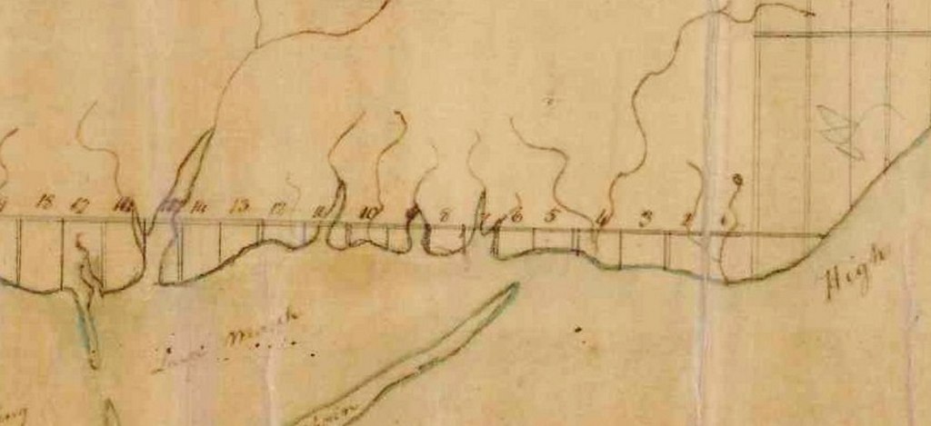
1791 “Plan of the Front Line of Dublin now York” shows a large stream in lot 15 with two branches stretch past what is now Queen Street. This would have been near where Woodbine Avenue and Queen Street East are today. This stream was later dammed and known as the Serpentine. This same map shows a small stream between Lots 11 and 12, two streams in Lot 11, one in the middle of Lot 10, a large stream in Lot 9 and another in Lot 7, with a final stream in Lot 7.[13]
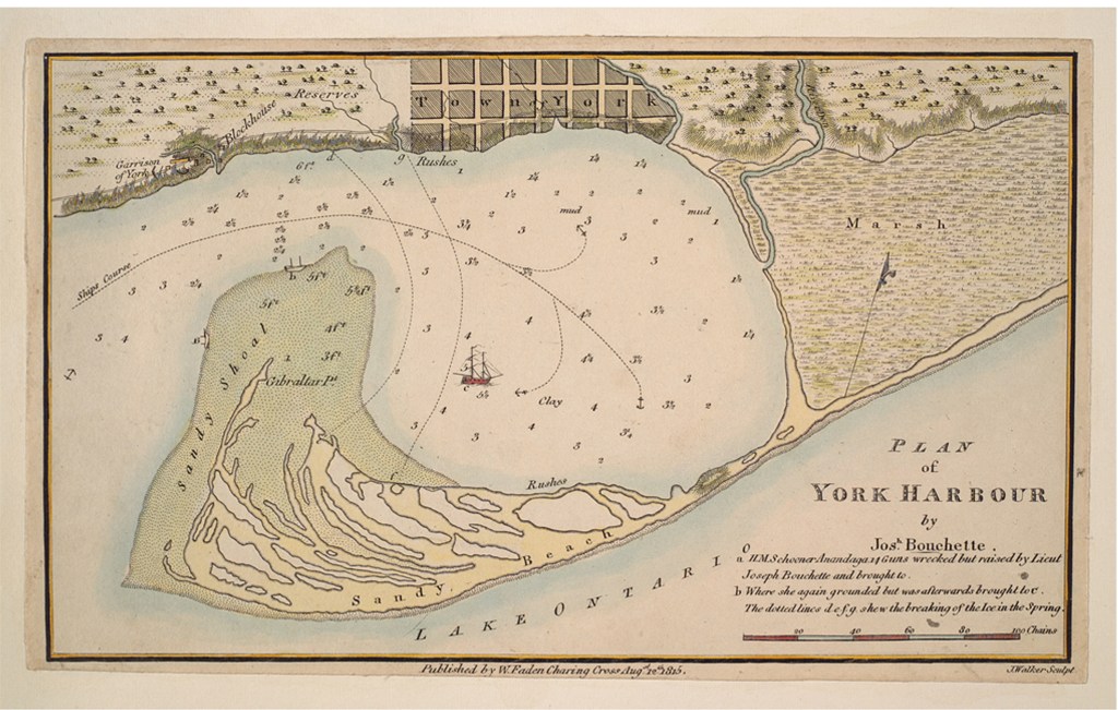
1792 Joseph Bouchette in 1832 remembered the marsh as it was when he first saw it: The formation of the peninsula itself is extraordinary, being a narrow slip of land, in several places not more than sixty yards in width, but widening towards its extremity to nearly a mile. It is principally a bank of sand, slightly overgrown with grass. The widest part is very curiously intersected by many large ponds, that are the continual resorts of large quantities of wild fowl. A few trees scattered upon it greatly increases the singularity of its appearance: it lies so low that the wide expanse of Lake Ontario is seen over it. The termination of the peninsula is called Gibraltar Point, where a blockhouse has been erected. A lighthouse at the western extremity of the beach has rendered the access to the harbor safely practicable by night. The eastern part of the harbor is bounded by an extensive marsh, through which the River Don runs before it discharges itself into the basin. [14]
His 1792 map shows the Peninsula as wooded with scattered ponds and wetlands on the north shore at the east end. It shows a portage or “carry place” and “Indian Huts” at the foot of what is now Parliament Street. A sandy beach covered the whole south side of the Peninsula (later Toronto Island).[15]
1793 Alexander Aitkin’s 1793 Plan of York Harbour also shows a number of small streams in the Leslieville area.[16] A creek flowed through the area east of the Don River around Saulter and Lewis Streets. (Later this area became heavily industrialized). Heward Creek flowed from springs near Broadview north of Gerrard in what is now Riverdale to enter Ashbridge’s Bay near Heward Avenue. It cut a deep ravine at Gerrard and Carlaw Avenue. It down to the Bay along Boston Avenue, just east of the Wrigley Chewing Gum factory.[17]

1793 In May 2, 1793 Simcoe and seven officers first visited Toronto. They followed the shore line in a bateau around the west end of the Lake. Simcoe considered Toronto a fine harbour. In July 29, 1793 Mrs. Simcoe sailed to Toronto on the sloop Onondaga. They camped in tents, originally used by the explorer Captain Cook. The campsite was east of the Garrison. Elizabeth Simcoe recorded her first impressions of the Toronto Islands. She describes in her journal a “low spit of land covered with wood” that “breaks the horizon of the Lake” and “greatly improves the view.” Writing in 1793, Lady Simcoe, wife of the first lieutenant-governor, referred to the Islands as “my favourite sands.” Hon. Peter Russell: “Nothing can be pleasanter than this beautiful Bason, bounded on one side by a number of low sandy peninsulas, and on the other by a bluff bank of 60 feet, from which extends back a thick wood of huge forest trees.”[18]
1793 Originally the city was covered by dense forests, and is so described in the early surveys (the first survey was made in 1793).
Much of this timber was pine and hardwood mixed, but there were tracts of solid pine. This pine has long disappeared, only a stick remaining here and there on the ridge behind the city. There is much second growth pine and hardwood, and in the ravines outside the city some of the original forest remains. There are many wild places still remaining where forest birds may find suitable breeding places. In the city the streets are very generally planted with shade trees; there are many trees about the houses, and in the parks and open places there is plenty of shelter and food for birds.
1793 Sarah Ashbridge, a widow, on her arrival at York from Philadelphia in 1793 with her two sons and three daughters, first settled near the mouth of the Don on land by the bay. The Marsh was named after her family. The Ashbridges chose their property at the more eastern end of Ashbridge’s Bay, away from the extensive marsh at the west end. On shore breezes across the open bay would have lessened the plague of mosquitoes. . It is said that upon entering the bay in their boat, someone in the party blew a blast on a big shell, of which at least two were brought with them and used later for dinner horns, and that the ducks flew up in thousands at the sound.[19]
1794 Mrs. Simcoe said in her diary that she herself enjoyed doing this:
We dined in a meadow on the peninsula, where I amused myself with setting fire to a kind of long dry grass, which burns very quickly, and the flame and smoke run along the ground very quickly and with a pretty effect.[20]
Lady Simcoe’s diary includes a number of descriptions of the environment of the Lower Don and Ashbridge’s Bay in the 1790s. It is clear from her references that the area was one of great environmental richness and diversity. Among the species named in contemporary accounts are wolves, bear, deer, wolverine, lynx, eagles, ducks and other wildfowl. As with Alexander Aiken, Lady Simcoe’s diary includes a reference to native peoples in the area – in this case harvesting the natural resources of the Don estuary. Her entry for January 26-27, 1794 records groups of “Indians” ice fishing on Ashbridge’s Bay, as follows:
We went to the Don to see Mr. Talbot skate. Capt. Aeneas Shaw’s children set the marshy ground [the marsh at Ashbridge’s Bay] below the bay on fire; the long grass on it burns with great rapidity this dry weather. It was a fine sight, and a study for flame and smoke from our house. At night the flames diminished, and appeared like lamps on a dark night in the crescent at Bath. I walked below the bay and set the other side of the marsh on fire for amusement.
The Indians have cut holes in the ice, over which they spread a blanket on poles, and they sit under the shed, moving a wooden fish hung to a line by way of attracting the living fish, which they spear with great dexterity when they approach.
According to Lady Simcoe, the fish caught in this manner included “maskalonge” (muskellunge) and pickerel (Simcoe, 2001:214-215). Elsewhere, in her diary entry for January 23 1796, she wrote of red trout caught by ice fishing on the Don River. [21]
1800 Wild hay.—This is the product of various kinds of wild grass, which grow on the natural meadows or marshes of the country. Some, of course, are preferable to others; the most esteemed seemed to be, what is called “the spear “grass,” and that which is most abundantly intermixed with the wild pea-vine. The earlier they are cut and cured, when full grown, the better; and it is though a greater advantage, when ricking them, to scatter, at intervals, layers of salt. These wild meadows or marshes afford excellent pasture in the spring, before the flies appear; and in the autumn after the cold has quelled them. In the winter there were often fires fanning across the dry reeds and cattails.[22]

1801 John Bennett wrote:
I am just recovering from a severe fit of fever and ague which confined me to bed for ten days past — nobody can escape it who pretends to live here. Mr. McLean, Clerk of the Assembly who will deliver you this, has also been extremely ill with [it] and in some families one person is not able to assist another; there is a marsh about 1/2 mile from where I live from which a thick fog arises every morning — people attribute it in great measure to that and to the low and uncultivated state of the country. I have been delirious almost every day, but by taking of bark every two hours according to Dr. McCaulay’s prescription I have missed the ague these two days past — I hope in God I shall have no more of it, it sets me quite crazy.[23]
1805 gentleman farmer D’Arcy Boulton completed one of the first known engineering projects on Ashbridge’s Bay:
“Having land in the vicinity of the marsh at the east end of the town he, at great expense, cut an open channel through a portion of this marsh, on the eastern side of the Don River, in front of this property. This channel has continued open ever since, and is known as “Boulton’s Ditch.” Fishermen and skiffmen along the Don appreciate the ditch, however, as it forms a communication between the Don and Ashbridge’s Bay.[24]
D’Arcy Boulton, 1805:
The river Don empties into the harbour a little above the town, running through a marsh, which, when drained, will afford most beautiful and valuable meadows. This has already been affected in a small degree, and will no doubt be extended; the difficulty is not very great, and from the contiguity of the marsh to the town the expense, though heavy, may be supplied. The long beach or peninsula affords a most delightful walk or ride, and is considered as so healthy by the Indians, that they frequently resort to it when indisposed.[25]
1807 From the very early days of European settlement, there were calls for the draining of Ashbridge’s Marsh. Malaria was a very real problem in 19th Century Toronto. In 1807, “A Country Subscriber”, writing to the Gazette, put forth his views, as follows:
To the Printers of the York Gazette: It cannot have escaped the observations of any person acquainted with the River Don that at times, and in all high winds, it is impossible to get to or from the town with craft of any description through the present channel [Western Gap]. Whereas, if nature’s hint was improved — I mean the break which took place three years ago–the navigation would be made safe and practicable at all times, and, without any of the inconveniences attending the old, the new channel would shorten the distance from York to the Don Mills upwards of a mile. It would also, by being properly opened, do more towards draining the marsh than a large sum of money laid out in any other possible way. If permission could be obtained from the Governor and Council for the purpose, the few feet to be cut for opening the new channel would be done by subscription. Added to is other general advantages, it would be a great object to the owners of cattle and others who do not possess pasture ground in the neighbourhood.[26]
1810 [circa] “The advancement of this place to its present condition has been effected with the lapse of six or seven years, and persons who have formerly travelled in this part of the country are impressed with sentiments of wonder on beholding a town which may be termed handsome, reared as if by enchantment in the midst of the wilderness…the scene is agreeable and diversified; a blockhouse, situated upon a wooded bank, forms the nearest object; part of the town, points of land cloathed with spreading oak trees, gradually receding from the eye one behind another, until terminated by the buildings of the garrison and the spot on which the governor’s residence is placed, compose the objects on the right. The left side of the view comprehends the long peninsula which encloses this sheet of water, beautiful on account of its placidity, and rotundity of form; the distant lake, which appears bounded only by the sky, terminates the whole”. [27]
1810 According to Henry Scadding, “The language of the early Provincial Gazetteer, published by authority, is as follows: “The Don empties itself into the harbour, a little above the Town, running through a marsh, which when drained, will afford most beautiful and fruitful meadows.’ In the early manuscript Plans, the same sanguine opinion is recorded, in regard to the morasses in this locality [Ashbridge’s Bay]. On one, of 1810, now before us, we have the inscription: ‘Natural Meadow which may be mown.’ On another the legend runs: ‘Large Marsh, and will in time make good Meadows.’ On a third it is: ‘Large Marsh and Good Grass.’[28] In the winter there were often fires fanning across the dry reeds and cattails. Once a year in the early part of the century the marsh was intentionally set on fire as a spectacle for the town. [29]
These fires helped to maintain the oak savannah and prairie vegetation found on the Peninsula, now Toronto Islands, but also found in Ashbridge’s Marsh.
1810 At first the Mississauga dominated the fishery, selling fish near the St. Lawrence Market.
1810 The language of the early Provincial Gazetteer, published by authority, is as follows:
“The Don empties itself into the harbour, a little above the Town, running through a marsh, which when drained, will afford most beautiful and fruitful meadows.’ In the early manuscript Plans, the same sanguine opinion is recorded, in regard to the morasses in this locality [Ashbridge’s Bay]. On one, of 1810, now before us, we have the inscription: ‘Natural Meadow which may be mown.’ On another the legend runs: ‘Large Marsh, and will in time make good Meadows.’ On a third it is: ‘Large Marsh and Good Grass.’”[30]
1810 The Rev. John Doel, who died in 1909 at the age of 93, remembered his “boyhood days [when] sea salmon were sometimes caught in the [Don] river.”[31]
1811 After almost twenty years of British settlement, George Heriot, Deputy Postmaster-General described York:
“The advancement of this place to its present condition has been effected with the lapse of six or seven years, and persons who have formerly travelled in this part of the country are impressed with sentiments of wonder on beholding a town which may be termed handsome, reared as if by enchantment in the midst of the wilderness.” Heriot went on, seen from a position near the Don, “the scene is agreeable and diversified; a blockhouse, situated upon a wooded bank, forms the nearest object; part of the town, points of land cloathed with spreading oak trees, gradually receding from the eye one behind another, until terminated by the buildings of the garrison and the spot on which the governor’s residence is placed, compose the objects on the right. The left side of the view comprehends the long peninsula which encloses this sheet of water, beautiful on account of its placidity, and rotundity of form; the distant lake, which appears bounded only by the sky, terminates the whole”. [32]
1819 …in the summer of 1819, when a degree and a continuance of warmth was experienced, greater than had been know for the preceding twenty years; and when, amidst the universal sickliness which prevailed in both provinces, that of the western district of the Upper Province, seemed somewhat to preponderate.
The fact that increased sickliness arises in very hot and dry seasons, may seem here to demand explanation; for it is the action of heat upon moisture which depraves the air. This was the exact case in the instance in question.[33]
1819 E.A. Talbot visited York. He noted:
“The situation of the town is very unhealthy; for it stands on a piece of low marshy land, which is better calculated for frog-pond or beaver-meadow than for the residence of human begins. The inhabitants are, on this account, much subject, particularly in Spring and Autumn, to agues and intermittent fevers; and probably five-sevenths of the people are annually afflicted with these complaints. He who first fixed upon this spot as the site of the capital of Upper Canada, whatever predilection he may have had for the roaring of frogs, or for the effluvia arising from stagnated waters and putrid vegetables can certainly have had not very great regard for preserving the lives of his Majesty’s subjects.”[34]
Soldiers had served in India and other tropical outposts of Britain. When mosquitoes bit them, the insects picked up the parasite and passed tertiary malaria on. Settlers believed that “bad air” (“mal aria”) rising off rotting vegetation malaria (ague, lake fever, canal fever).
1820 [circa] The lakes abound with fish…Salmon (of an excellent description) is found as high up as the cataract of Niagara, but that is a barrier, of course, which they cannot surmount. They abound more on the north than on the south side of Lake Ontario…a fish called the white fish. It is somewhat larger than the mackerel, is taken in November and affords an excellent winter stock.
The sturgeon abounds in its season, and when well cured, is, in my opinion, extremely palatable; but is principally used by Indians.
There are several other kinds, very plentiful in their seasons, and very good; such as a species of herring (as it is called), white and black bass, &c. &c.…
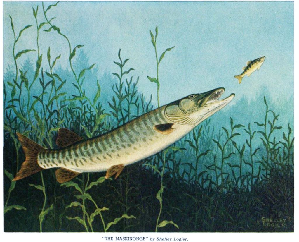
A large fish, called the muskinunge … not frequently taken, is esteemed one of the finest in the lakes.[35]
1820 Henry Scadding came to Toronto in 1820 when he was a young boy. His father, John Scadding, and family were some of the first British settlers on the Don River. Henry Scadding described Ashbridge’s Bay:
Southward in all the distance was a great stretch of marsh with the blue lake along the horizon. In the summer this marsh was one vast jungle of tall flags and reeds, where would be found the conical huts of the muskrat, and where would be heart at certain seasons the peculiar gulp of the Bittern.[36]

He wrote of the wildlife:
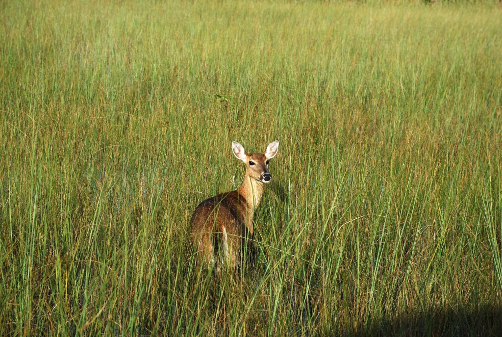
About the dry, sandy table-land…the burrows of the fox, often with little families within, were plentifully to be met with. The marmot, too, popularly known as the woodchuck, was to be seen on sunny days sitting up upon its haunches at holes in the hillside. We could at this moment point out the ancient home of a particular animal of this species whose ways we used to note with some curiosity. Here were to be found racoons also; but these, like the numerous squirrels–black, red, flying, and striped–were visible only towards the decline of summer when the maize and the [nuts] began to ripen. At that period also bears, he-bears and she-bears accompanied by their cubs, were not unfamiliar objects wherever the blackberry and raspberry grew. in the forest, moreover, hereabout a rustle in the underbrush and something white seen dancing up and down in the distance like the plume of a mounted knight might at any moment indicate that a group of deer had caught sight of one of the dreaded human race and, with tails uplifted, had bounded incontinently away.[38]
“…skiffs and canoes, log and birchbark, were to be seen putting in, weighed heavily down with fish, speared or otherwise taken during the preceding night in the Lake, bay, or neighbouring river.
“…a wide and clean gravelly beach with a convenient ascent to the cliff above. Here on fine mornings at the proper season skiffs and canoes, log and birchbark, were to be seen putting in, weighed heavily down with fish, speared or otherwise taken during the preceding night in the Lake, bay, or neighbouring river. Occasionally a huge sturgeon would be landed, one struggle of which might suffice to upset a small boat. Here were to be purchased in quantities salmon, pickerel, masquelonge, whitefish and herrings, with the smaller fry of perch, bass, and sunfish. Here too would be displayed unsightly catfish, suckers, lampreys, and other eels; and sometimes lizards, young alligators [mud puppies i.e. salamanders] for size.[39]
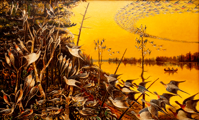
“Several of his sons [Hewards], while pursuing their legal and other studies, became also ‘mighty hunters’–distinguished, we mean, as enthusiastic sportsmen. Many were the exploits reported of them in this line… the marshes about Ashbridge’s Bay and York harbour itself all abounded with wild fowl. Here loons of magnificent size used to be seen and heard; and vast flocks of wild geese, passing and re-passing high in air in their periodical migrations. The wild swan, too, was an occasional frequenter of the ponds of the Island.”[40]
1820 Malaria was a reality in Upper Canada and most settlers wanted nothing to do with wetlands, fearing the miasmas rising from them which were alleged to cause illness. Charles Stuart wrote:
Marshy and swampy situations should be particularly avoided, if possible; and where altogether unavoidable, the house should be built as remote from them, as consistent with any tolerable degree of convenience in other respects.
The wood about the dwelling should be immediately and entirely cleared away: no branches or logs being left, as is very universally the case, to gather and preserve stagnant and putrifying moisture.[41]
1820 William Lea, founder of Leaside, describes it as he knew the forest in 1820:
About one-third of the distance from the Bay was in the original woods consisting of Beech, Maple, White Ash, Buttonwood, and some very large white pines on the higher portion of the flats. In the marshy places, cedar, hemlock, black spruce and balsam. The banks on each side were thickly wooded with similar kinds of timber.
1824 “The situation of the town is very unhealthy; for it stands on a piece of low marshy land, which is better calculated for frog-pond or beaver-meadow than for the residence of human begins. The inhabitants are, on this account, much subject, particularly in Spring and Autumn, to agues and intermittent fevers; and probably five-sevenths of the people are annually afflicted with these complaints. He who first fixed upon this spot as the site of the capital of Upper Canada, whatever predilection he may have had for the roaring of frogs, or for the effluvia arising from stagnated waters and putrid vegetables can certainly have had not very great regard for preserving the lives of his Majesty’s subjects.”[42]
1825 Howison, who published in 1825, and consequently visited Canada before that date, was not impressed with Ashbridge’s Bay:
“The town of York is situated on the shore of Lake Ontario, and has a large bay in front of it, which affords good anchorage for small vessels. The land all round the harbour and behind the town is low, swampy, and apparently of inferior quality; and it could not be easily drained, as it lies almost on a level with the surface of the lake. The town, in which there are some good houses, contains about 3000 inhabitants. There is but little land cleared in its immediate vicinity, and this circumstance increased the natural unpleasantness of its situation. The trade of York is very trifling; and it owes its present population and magnitude entirely to its being the seat of government; for it is destitute of every natural advantage except that of a good harbour.”[43]
1825 The famous painter Paul Kane (1810-1871) recalled his boyhood in York when he saw “as many as 100 light-jacks gliding about the Bay of Toronto”.[44]

1830 mostly Irish, began a commercial fishery. Fisher families lived on the sandbar. Part of it became known as “Fisherman’s Island”.
1830 Passenger Pigeons darkened the sky:
…some two summers ago [1830] a stream of them took it into their heads to fly over York; and for 3 or 4 days the town resounded with one continued roll of firing, as if a skirmish were going on in the streets, — every gun, pistol, musket, blunderbuss, and firearm of whatever description was put in requisition. The constables and police magistrates were on the alert, and offenders without number were pulled up, — among whom were honourable members of the executive and legislative councils, crown lawyers, respectable staid citizens, and last of all the sheriff of the county; till at last it was found that pigeons, flying within easy short, were a temptation too strong for human virtue to withstand; and so the contest was given up, and a sporting jubilee proclaimed to all and sundry.[45]
1830s George, Isaac, John and Thomas, The Cary (or Carey) Brothers were freemen who came from Virginia to Toronto in the 1830s where they opened several barber shops. They became prominent ice merchants.
1831 Joseph Bouchette, wrote:
[The] Credit, Etobicoke, Humber, and Don rivers, flowing into Lake Ontario, are the most worthy of particular mention. They in general abound with excellent fish, and especially salmon, great quantities of which are annually speared in the river Credit for the supply of the western country. Besides these rivers, a great number of “creeks” of considerable importance discharge their streams into the lake…[46]
The formation of the peninsula itself is extraordinary, being a narrow slip of land, in several places not more than sixty yards in width, but widening towards its extremity to nearly a mile. It is principally a bank of sand, slightly overgrown with grass. The widest part is very curiously intersected by many large ponds, that are the continual resorts of large quantities of wild fowl. A few trees scattered upon it greatly increases the singularity of its appearance: it lies so low that the wide expanse of Lake Ontario is seen over it. The termination of the peninsula is called Gibraltar Point, where a blockhouse has been erected. A lighthouse at the western extremity of the beach has rendered the access to the harbor safely practicable by night. The eastern part of the harbor is bounded by an extensive marsh, through which the River Don runs before it discharges itself into the basin. [47]
1832 “Tiger” Dunlop described the wildlife of southern Ontario:
Otters are abundant…The foxes are smaller and of a more delicate fur than ours; indeed, the silver fox produces one of the finest furs we have…The racoon is hunted in marshy grounds, by moonlight, treed by dogs, and then either short or killed by felling the tre. He is valuable for his fur, and when baked with potatoes his flesh is estemed a delicacy. I never ate it myself, from prejudice, — which is the most inconsistent, as I do not object to a black squirrel,and have made a most comfortable breakfast off, a hind quarter of a bear cub. The beaver is rarely seen [due to over-trapping], as you must look for him deep in the woods, he always flying the habitations of man. The varieties of the pole-cat kind are numerous, including the ermine. The wolf is the only very mischievous beast of prey we have, and he worries sheep…[48]
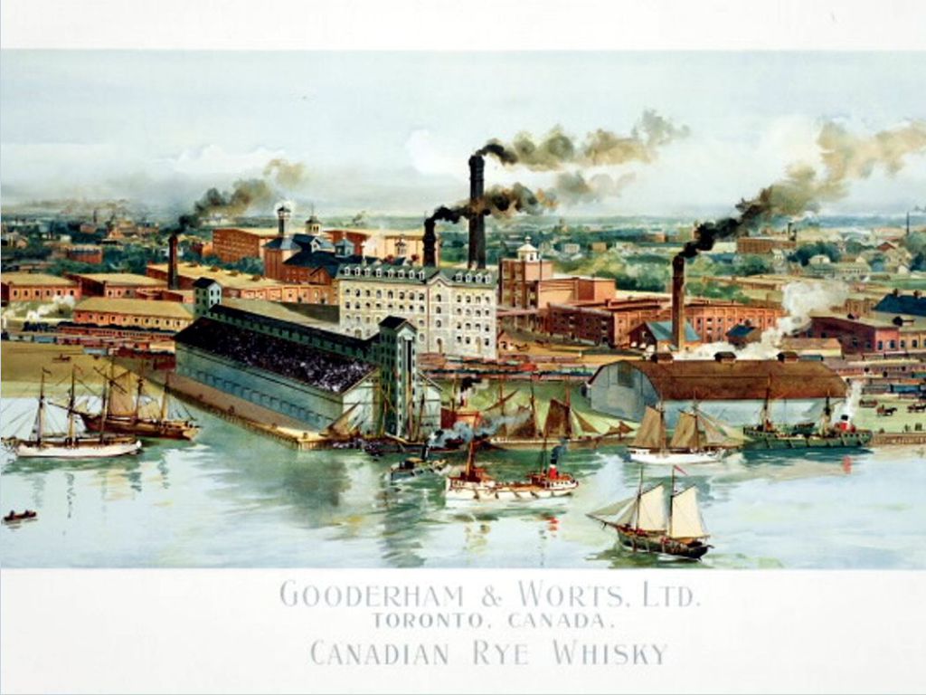
1832 Muddy York had a population of 6,100. Two Englishmen, William Gooderham and his brother-in-law James Worts, established a flour mill operation. Their windmill became a well-known sight and the lakefront’s chief survey point. A wooden still was soon raised by the windmill.
1833 Bonnycastle stated on his map of Ashbridge’s Bay: “…this shore is a marshy meadow with deep runs of water…this sandy ridge extends for 3 miles and the space between it and the bank is a deep swamp, full of intricate channels and extensive bonds through which the Don finds an outlet by a breach in the sands at the N.E. corner.”[49] Bonnycastle’s map showed: “White and herring fishery established along this shore.” The lake and bay were dangerous with shifting shoals and tricky currents.[50]
1834 York was renamed Toronto in 1834.
1835 Richard Bonnycastle suggested building an underground sewer main along the harbour front into the Don, and from there into Ashbridge’s marsh.
1836 Anna Jameson:
“A little, ill-built town, on low land, at the bottom of a frozen bay, with some government offices built of staring red brick in the most tasteless, vulgar style imaginable, 3 feet [.9 metre] of snow all around and the grey, sullen wintry lake, and the dark gloom of the pine forest. I did not expect much but for this I was not prepared. [51]
1837 Gooderham & Worts sold a gallon of whiskey to residents and innkeepers for 50 cents and within seven years whiskey sales reached an astonishing 241,000 litres a year.
1838 Some agreed that the wolf was not the monster of Brothers Grimm:
[they came] within sixty or eighty yards, but always turning tail when faced, and skulking away. They abound in the woods, are a great nuisance, inasmuch as they prevent us keeping sheep. On first coming into the Bush, I used to be affected by a very unpleasant sensation, whenever I heard the brutes howling on the Lake shore of an evening, or saw them sulking around the skirt of the clearing, but after a time the feeling fear wore off; and, I must say, to give them their due, I have never known them disposed to encroach upon the limits which a proper sense of our respective grades in the scale of creation would suggest to them. [52]
1839 Anna Jameson described Ashbridge’s Bay: “… a mere swamp, a tangled wilderness, the Birch, the Hemlock, and the Tamarack trees, were growing down to the water’s edge, and even into the lake.”[53]
1840 [circa] Speaking of the Heward family:
“Several of his sons, while pursuing their legal and other studies, became also ‘mighty hunters’–distinguished, we mean, as enthusiastic sportsmen. Many were the exploits reported of them in this line… the marshes about Ashbridge’s Bay and York harbour itself all abounded with wild fowl. Here loons of magnificent size used to be seen and heard; and vast flocks of wild geese, passing and re-passing high in air in their periodical migrations. The wild swan, too, was an occasional frequenter of the ponds of the Island.”[54]
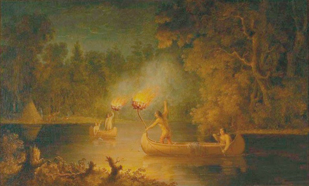
1840 [circa] Salmon-fishing commences in October, when the fish run up the rivers and creeks in great numbers. The usual way of catching them is by spearing, which is done as follow.–An iron grate–or jack, as it is called by the Canadians–is made in the shape of a small cradle, composed of iron bars three or four inches apart. This cradle is made to swing in a frame, so that it may be always on the level, or the swell would cause the pine-knots to fall out. Fat pine and light-wood are used to burnin the jack, which give a very brilliant light for several yards roung the bow of the canoe. The fish can be easily seen at the depth of from four to five feet. One person sits in the stern and steers with a paddle, propelling the canoe at the same time. The bowman either kneels or stands up with the spear poised ready for striking. An expert hand will scarcely miss a stroke. I have know two finshermen in this manner kill upwards of two hundred salmon in one night. I believe, however, that the fishing is not nearly so productive as formerly.[55]
…Thirty years ago, all the small streams and rivers, from the head of the lake downwards to the Bay of Quinte, used to abound with salmon. The erection of saw-mills on the creeks, and other causes, have tended materially to injure the fisheries. White fish and salmon-trout are, however, taken in vast quantities, particularly the former, which has become quite an article of commerce….Lake Ontario abounds with herring, of much the same flavour as the sea species, but not so strong and oily, nor so large. Sturgeon, pike, pickerel, black bass, sheep-heads, mullets, suckers, eels, and a variety of other fish, are plentiful in these waters: the spring-creeks and mill-ponds yield plenty of spotted trout, from four ounces to a pound weight; they are easily caught either with the worm or fly.[56]
1842 The Canadian Naturalist in 1881 described the marsh:
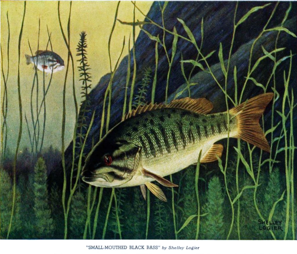
In 1842, many of the large Canadian marshes were teeming with geese, duck, snipe and plover indigenous to the country. Toronto marsh was then a good shooting ground, and many birds which regularly visited it at that time are considered of rare occurrence to-day. A large Black Bass … then had its habitat in Ashbridge’s Bay, and many a fine 20 lb. fish of this species did Joe Lang spear in its surrounding marshes.[57]
1846 Prior to the landscape modifications of the early 20th century, Ashbridge’s Bay was separated from Lake Ontario by a peninsula that extended from Wards Island to the Lake Ontario shore near Woodbine Beach. The bay was similarly separated from Toronto harbour by a sand spit. According to an 1846 military sketch, Ashbridge’s Bay had a maximum depth of eight to ten feet (2.5-3 metres) (Stinson, 1990:56). The marsh itself was located on the west side of the open water of Ashbridge’s Bay; at its maximum point, it extended as far east as the present alignment of Leslie Street (Ibid:57). … the Don River originally had two main channels through the delta on the western edge of the marsh. A long channel exited from the centre of the marsh. A short high water channel turned westward without entering the marsh.
1848 The number of citizens is becoming few indeed who remember Toronto Bay when its natural surroundings were still undefaced and its waters pure and pellucid. From the French Fort to the Don River, curving gently in a circular seep, under a steep bank forty feet high covered with luxuriant forest trees, was a narrow sandy beach used as a pleasant carriage-drive, much frequented by those residents who could boast private conveyances. A wooden bridge spanned the Don and the road was continued thence, still under the shade of umbrageous trees, almost to Gibraltar Point on the west, and past Ashbridge’s Bay eastward. At that part of the peninsula, forming the site of the present east entrance, the ground rose at least thirty feet above high-water mark, and was crested with trees. Those trees and that bank were destroyed through the cupidity of city builders, who excavated the sand and brought it away in barges to be used in making mortar. This went on unchecked till about the year 1848, when a violent storm—almost a tornado– from the east swept across the peninsula, near Ashbridge’s Bay, where it had been denuded of sand nearly to the ordinary level of the water. This aroused public attention of the danger of further neglect.[58]
1850 Big game was relatively rare, but the pioneers were not fussy:
..the principal game to be found in Canada now consists of Squirrels. These, if properly cooked, are really excellent eating, the black squirrel resembling hare, and the red would scarcely be distinguished from chicken.[59]
1850 Sandford Fleming studied the movement of the sand-bars and calculated that twelve hectares had been added to the western section of the sand-bars over the previous 50 years.
1850 One writer reported fishing for salmon in Ontario by jack-lighting:
“One of the most exciting amusements at this season of the year, is salmon-fishing. In order to enjoy this sport, I made a canoe sixteen feet in length, and two feet nine inches at its greatest breadth.”
1850 to 1911 control of the Toronto harbour was divided between a Harbor Trust, railway companies, the City of Toronto, and private landowners. The harbour was put under the control of a Board of Commissioners. The chairman was nominated by the government, two members by the City Council, and two by the Board of Trade. Controlling the chairman, the Government controlled the harbour and of the harbour dues.[61] Samuel Thompson was a Commissioner:
In the spring of 1849, the chairman of the Harbour commission was Col. J. G. Chewett, a retired officer I think of the Royal Engineers; the other members were Ald. Geo. W. Allan and myself, representing the City Council; Messrs. Thomas D. Harris, hardware merchant, and Jno. G. Worts, miller, nominees of the Board of Trade. I well remember accompanying Messrs. Allan, Harris and Worts round the entire outer beach, on wheels and afoot, and a very pleasant trip it was. The waters on retiring had left a large pool at the place where they had crossed, but no actual gap then existed. Our object was to observe the extent of the mischief, and to adopt a remedy if possible. Among the several plans submitted was one by Mr. Sandford Fleming, for carrying out into the water a number of groynes or jetties, so as to intercept the soil washed down.[62]
1850 Tiny creeks that we hardly think could support minnows were valuable salmon streams. This 1850 description of a similar small stream demonstrates this: Mr. Stephens showed me a small stream runing through his farm, which I could easily jump over. He told me that one afternoon he was watering his horses, when he perceived a shoal of salmon swimming up the creek. He had no spear at home, having lent it to a neighbour. He, however, succeeded with a pitchfork in capturing fifty-six fine fish. [64]
These little creeks or brooks were fed by springs gushing out of the gravel and sand wherever water met impermeable layers of clay. They provided valuable spawning grounds for Atlantic salmon and brook trout and native peoples and settlers fished this brooks. All these creeks are now underground forming part of the sewer system.[65] In the little valleys, with their rich-soiled floodplains, terraces would have formed. Trees growing there would have included: black willows, peach-leafed willows and sycamores along with black walnut.[66]
1852 An important development in the mid 19th century was the arrival of the railroad that linked the city and the harbour facilities with the hinterland. Toronto was the biggest port on Lake Ontario in 1852 when Ontario’s first railroad, the Ontario, Simcoe and Huron Union Railroad, brought the iron horse into Toronto. The demand for an improved harbour was persistent through the latter half of the nineteenth century.
1853 The forest where the Ashbridges settled had good timber: oak and pine on the dry sandy soil, and maple and beech, on the clayey soils closer to the lake and in the bottom of the ravine. Experienced settlers, like John and Jonathan Ashbridge, chose their land (if they had a choice) often on the basis of what kind of timber grew there. Much of the area was sandy, but they chose land with a lot of clay and heavily timbered.
White pine, or hemlock ridges, are almost always sandy, and good for little – except the timber, which is valuable, if near enough to water. White-pine mixed with hard-wood generally indicates strong clay land, good for wheat…[67]
1853 Engineer, W. Shanly wanted to cut a channel for the Don though the Ashbridge’s marsh into the lake to scour out the Don. Another engineer, Hind, suggested channeling the City’s sewage into the marsh where it would “become inoffensive, being consumed by vegetation.”[68]
1854 Ice! Ice!! Ice!!! The Undersigned begs to return his best thanks to his customers, for the liberal patronage he has received for the last nine years, and to announce that he has enlarged and added to the number of his Ice Houses, having now four which are filled with pure and wholesome Spring Water Ice, from Yorkville. He is prepared to supply the same to consumers, by contract or otherwise, during the season, commencing from the 1st of June next. The Ice will be conveyed by waggon daily, to places within six miles of Toronto. All orders sent to Thomas F. Cary, hairdresser, Front Street, two doors from Church Street, will be punctually attended to. R.B. Richards, Toronto April 19, 1854.[69]
1854 Sandford Fleming, in 1854, said: All the drains and sewers empty into the [Toronto] Bay, making it, in truth, the grand cesspool for a population of 30,000 inhabitants with their horses and cattle.[70] Fleming proposed diverting the Don directly into Ashbridge’s Bay, making it “an effective conduit for the sewage of the city.”[71] Engineers tried to solve the twin problems of sewage disposal and obtaining clean drinking water without treating the sewage.
1854 Thomas Cary and Richard B. Richards opened four ice houses. Some came from springs; some from Ashbridge’s Bay:
1855 A winter gale blasted a 50 yard wide gap in the bank to a depth of three feet, but this “cut” was not permanent.
1855 In Leslieville “water rats” clustered south of Kingston Road on Laing Street and Lake Street (now Knox). According to J. McPherson Ross:
Quite a colony of fishermen lived nearby, among whom we remember the names of Doherty, Laings, Marsh, Goodwin, Crothers and others who, if not fishermen, were duck-hunters or trappers. Or they also enjoyed the boating, fishing, and bathing privileges which were here in all their primeval abundance and purity of nature becoming soiled and destroyed by the sewage and filth of the encroaching city.[72]
1856 Thomas Cary married Mary Ann Shadd, the publisher of the Provincial Freeman.
1857 Louis Pasteur (1822-1895) formulated the “germ theory”. The fact that bacteria cause infectious diseases is one of the foundations of modern medicine.[73] Toronto did not accept if for almost 50 years. Even doctors clung to the “miasma theory” that damp air caused disease.
1858 In 1853 John Quinn succeeded the Privats at the hotel on the sandbar. Another storm on April 13, 1858 opened a gap that was permanent, wiping out Quinn’s Hotel (formerly the Peninsula or Privat’s Hotel) in the process.[74]
Mrs. Quinn was alone with small children as the nor’easter tore the hotel apart and huge waves ate up the beach. Quinn arrived in morning and moved his family to safer ground. Parkinson’s Hotel was also washed away by the opening of the Eastern Gap. Here is a description of the storm: Between four and five o’clock yesterday morning, the waters of the lake completely swept over a large section of the Island, entirely carrying away Quinn’s Hotel and its appertainances, along with the excuse for a breakwater, erected by the Harbour Commissioners, and making a permanent Eastern Entrance to the Harbour, some 500 yards wide. The gale which led up to the partial washing away of the Island sprung up about five o’clock on Monday evening, and was then of such violence as to cause serious fears that the hotel would be blown down. The lake gained steadily on the Island and the Hotel until about four o’clock in the morning when the Hotel was completely swept away and a very wide entrance to our harbour–some four or five feet deep–was opened through the Island. In anticipation of such an event, Mr. Quinn erected a small building west of the Hotel into which he barely had time to move his family, and a small portion of his furniture before his former residence was borne away by the waves. He is said to be a very heavy loser.[75]
At first the channel was 4-5 feet deep, but by May 30, the Eastern Gap was broad enough for the schooners to pass through.[76] Some of the more puritanical Torontonians may have seen the storm as God’s punishment for the gambling, drinking and fighting that were hallmarks of Island hotels.
1858 After the great storm of 1858, the fishermen relocated elsewhere on the Island:
“Mr. Hanlan, sr., at first lived in a house down near the Eastern Gap. During a terrific gale this place was washed away by the roaring waters of the lake. As soon as the storm was over the family, nothing daunted, gathered their scattered timbers together, built a raft, on which they place their property, and drifted up the bay, with a fair east wind. They chanced to ground at the present Hanlan’s Point, and here they built their home and left a name.”[77]
Another storm opened the Eastern Gap to 500 yards wide and 10 feet deep.
1859 Gooderham & Worts a new series of buildings was erected by the water. The windmill already had been abandoned for steam power and torn down, but now a new steam powerhouse was built alongside a new distillery. The distillery alone cost 25,000 pounds to build and was made of one-metre thick limestone blocks chiseled out of Kingston quarries. The new operation could produce 35,000 litres of spirits a day.
1860 Gooderham & Worts 1860 pump house which fought the great fire has had its original steam engines replaced with gasoline ones. The stables are a car park. The 1860 office functioned as a lunch room. Some of the old buildings have new functions, such as one used for refurbishing drums for industrial alcohol.
1863 John McPherson Ross described it:
Ashbridge’s Bay…was a beautiful sheet of water when I first saw it in the summer of 1863, and was clean and good enough to drink, abounding in fish, and was the haunt of numerous wild fowl all summer. In the stormy, rainy fall, it was alive with wild ducks of all kinds that came to rest on their southern flight and to feed on plentiful masses of wild rice that grew in numerous patches. The marsh covered the shallow waters of the eastern part of the bay at the commencement of the sand bar by the foot of Woodbine avenue, as this roadway is now called. When the racetrack of that name was first built the marsh growth ended where the deep water started, and began again intermittently a little west of Leslie street. It was quite a fine sheet of water, and at the time of speaking the lake had made a cut at about the size of the present entrance.[79]
1865 to 1882, James G. Worts, son of James Worts, a founder of the distillery, was chair of the Harbor Trust.
1869 Gooderham & Worts a fire broke out in a fermenting room and quickly spread throughout the network of buildings. By morning more than $100,000 in damage had been done and many buildings were destroyed.
1870 [circa] Ernest Thompson Seton: “Dec. 3. I went collecting with J. Macpherson Ross, superintendent of Leslie’s Nurseries, an old art school friend of mine, who is still living in Toronto. We collected some Tree Sparrows. Later, I went to Lang’s cottage on the shore, borrowed his telescope and studied the sandy bar on Ward’s Island. There were several hundred Gulls, a few of them Saddlebacks, and, sitting on the ice, a very large bird which turned out to be a fine Golden Eagle.[80] [The eagle was shot].
1870 Compared to the huge shooting areas in the other parts of Canada, Toronto Harbour is like a pinpoint under a microscope. The microscope, however, captures such a great number of hunters, market gunners, guides, and sportsmen, and such an enormous number of decoys were used and made, that Toronto has become the epicenter of the most famous and most treasurer Canadian decoys.
The waterfowl were drawn by the marshlands of Ashbridge’s Bay to the east of Toronto Harbour, about five miles long by a mile wide. Protected by the sandy dunes of Fisherman’s Island, this was “the naturalist paradise” as described in 1870 by . Seton sketched a map of the bay in that year, and it and other contemporary outlines show the cottages and boathouses that dotted the shorelines and indicated the guidelines for the hunters in the marshes – “Knock ‘em Point,” “Lily-Pad Pond,” and “Catfish Joe’s.”[81]
Ernest Thompson Seton recalled Catfish Joe Lang who actually lived on an island in Catfish Pond:
Catfish Joe’s island…was some 3 or 4 feet above high-water level, and was the home of the wild recluse called Catfish Joe. He did some shooting but was more of a fisherman; and always in case of shortage he could drop a line in the right place to land a mess of catfish. He had a few hens on this island. A friend of his from the old country was visiting him once, and intended to stay a couple of days; but was soon nauseated by the bill of fare. Everything smelled and tasted of fish. Finally Old Joe, noticing his unrelish, said, “How would you like a couple of aigs?’ “sure thing,” said his friend, delighted at the chance to get a change from the fish taste. But, alas, when the eggs were served, they were the eggs of hens that were fed chiefly on fish scraps, and those eggs were just as strong as rank old catfish could make them.[82]
1872 Aug. 27 A Good Haul –A party of seven gentlemen wen t off on a fishing excursion yesterday to Ashbridge’s Bay, and returned with some of the finest salmon trout ever caught in the Lake. One of them weighted between seven and eight pounds, and six together forty pounds.[83]
1872 the Ontario Government passed an Act enabling the City of Toronto to build waterworks. The City took over the existing water works in 1875 and the new waterworks were built on Toronto Island near the Lighthouse. A basin 500 feet long and 150 feet wide was dug and 4,000,000 gallons of water filled it naturally, infiltrating through the sand. This was pumped under the Bay by a pumping station between John and Peter and distributed by mains to consumers.[84]
1878 The Christie Brothers started the Don Rowing Club, using an empty house on Overend Street (then Vine Street) as a clubhouse. William Laing of Leslieville and other local boat builders sold the rowing clubs skiffs (a one-person boat) and clinchers (another old-fashioned clinker-built boat). “The Dons” built a new club house at Morley Road.[85]
1879 1879-80 was an ice boom year due to a warm winter. Scarcity of ice was expected. “Ashbridge’s Bay and the Don supplied nearly all consumed in Toronto.”
1879 City looked for ways to get rid of its every mounting human excrement. Kivas Tully, C.E., in an 1879 report to the Harbour Commissioners, proposed diverting the Don to carry sewage directly into Ashbridge’s Bay.
1880 All was not work for the commercial fishermen. It was common a century ago for commercial fishermen, including, probably, those of Leslieville, to wash down their boats and gear. They would then take their families out in their little fishing schooners for a cruise on the Lake – after church, of course.![86]
1880 In the 1880s, according to an undated, anonymous manuscript in the Toronto Public Library, In the early days of Leslieville, there was a big ice house owned by the Sedgwicks. It was where the junction Leslie and Eastern Ave. is now [near the Loblaws Superstore]. The pilings near the ice house were excellent perches for fishing. The usual catch included sunfish, perch, bass and catfish, all warm water species that would be expected in a marsh or pond. As well, fishing was an active industry in the Bay right up until the Bay’s disappearance under landfill. Local residents sometimes ignored fishing regulations and Fishery Inspectors toured Ashbridge’s Bay from time to time, seizing nets.
1880 Leslieville’s residents turned to Ashbridge’s Bay for sports and recreation. On Saturday commercial fishermen washed down their boats and gear. On Sunday afternoon they took their families out in their little fishing schooners for a cruise on the Lake. People sang as they sailed over Ashbridge’s Bay; the tunes could be heard on shore. In winter people skated and sailed iceboats. Boys played shinny with sticks they made themselves out of a curved piece of wood. Instead of a puck, they used a ball of frozen horse manure (a “horse puckey”). Men laid out racetracks on the ice and crowds attended these horse races. Vendors sold hot food from little wooden shacks. Whiskey and beer, cheap and strong, flowed freely – at a price. In summer rowing was popular.
In the 1880s when the Lower Don River was straightened and channelized and the Government Breakwater was constructed to prevent effluent and marsh material from invading Toronto harbour from Ashbridge’s Bay. [87]
Ashbridge’s Bay steadily became more polluted with sewage and run-off from Gooderham’s cow byres. The worst ice was used for refrigeration while cleaner ice was used for drinks and to make ice cream. Dirty ice helped cause the typhoid epidemics that ravaged Toronto. There was growing concern over pollution from Gooderham’s barns at the mouth of the Don. Gooderham and Worts distillery pumped mash, left over from whiskey making, in a pipe across the Don and fed it to thousands of cattle penned in barns. Neighbours complained of the stench. Raw manure, as well as offal, poured into the Don from a slaughterhouse, from William Davies’ pork packing plant, soap factory and a tannery. However, the main source was Gooderham and Worts whose liquid manure ran off into Brown’s Pond, Ashbridge’s Bay, forming pools of stinking semi-solid waste that crusted over so that men could and did walk upon. Falling through and drowning in the foulness was a constant risk. The distillery planted rows of trees, Gooderham’s Grove, to hide the sight from passersbys on Kingston Road.

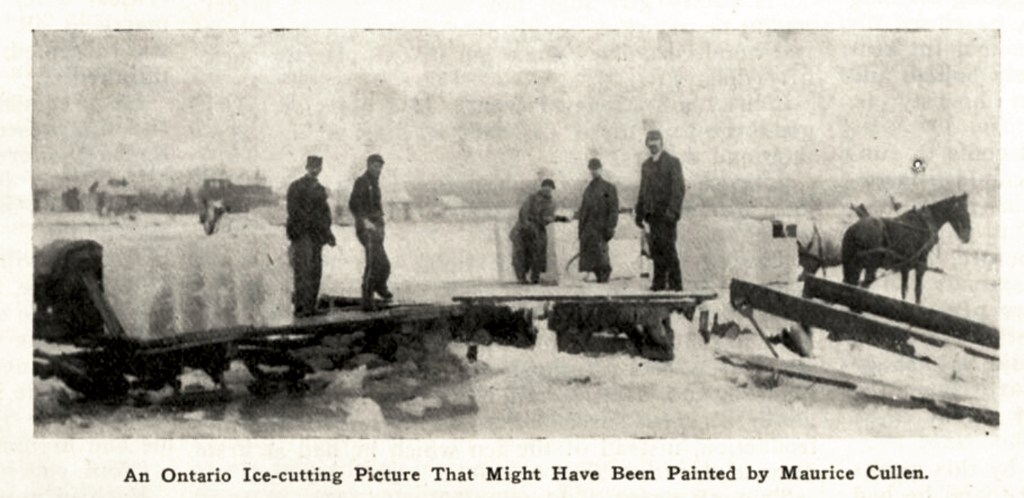
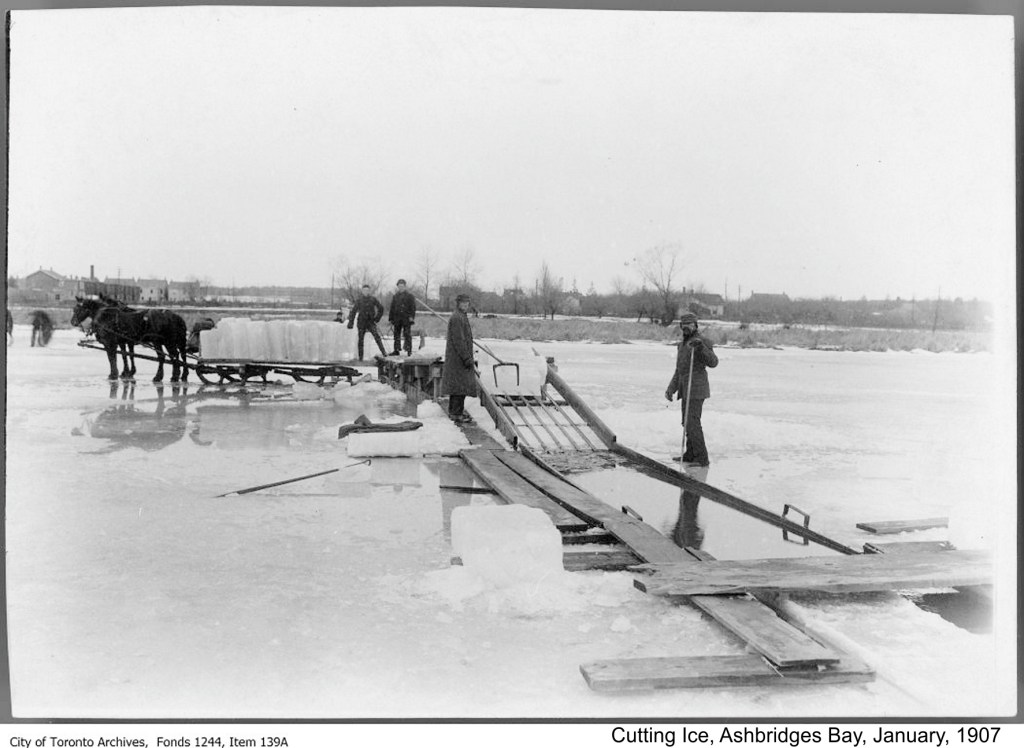
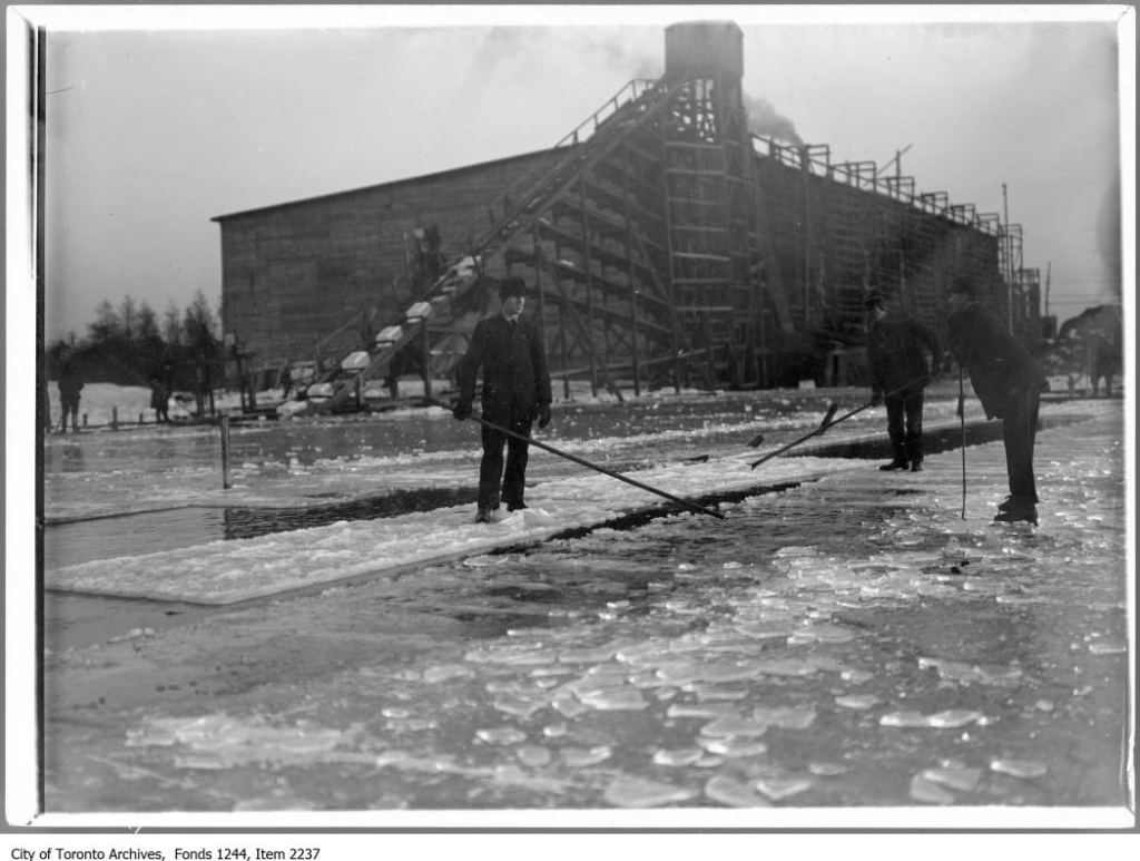
Cutting ice was important seasonal employment. The ice harvest began in January when the ice was thick enough. The ice companies shipped it by rail car even to the U.S. Ice houses had to be near railways: Work went on night and day when the markets were most favourable and signs of an approaching thaw made their appearance. … As much as $1,200 to $1,500 profit were made off ponds an acre or two in extent. Every available railway car was brought into service for the conveyance of ice, and yet a sufficient number were not to be had to meet the demand.[88] Men sawed the ice into blocks and packed it in sawdust in ice houses that lined Ashbridge’s Bay.
When the ice got to be six to eight inches, then the icemen appeared and several parties would commence the winter harvest. Great ice-houses in those days lined the bay at convenient spots for floating in the crystal blocks. This continued for several weeks, and was a busy time while it lasted. They generally saved all that the modest city required in those days, and it was not till the mild winter of 1880-81 that efforts were made to secure ice, outside, from Lake Simcoe, for the usual supply. Ice was cut, though, for many years afterwards till it was finally stopped by the city officials as being unfit for use. Up till then crowds of men and teams were kept busy in the operations of the ice harvest by the different companies engaged in that business. [89] Ice cutting was profitable, but low paying dangerous work. Men and horses drowned when they fell through the ice. Icemen lost their way in white-outs, to die of hypothermia. Woodbine Ice Company’s owner William Booth nearly drowned while out on the ice on a Sunday. Some likely thought he was being taught a lesson for working on the Sabbath.
1881 Ernest Thompson Seton, famous naturalist, reported: Dec. 3. I went collecting with J. McPherson Ross, superintendent of Leslie’s Nurseries, an old art school friend of mine, who is still living in Toronto. We collected some Tree Sparrows. Later, I went to Lang’s cottage on the shore, borrowed his telescope and studied the sandy bar on Ward’s Island. There were several hundred Gulls, a few of them Saddlebacks [Greater Black-backed Gulls], and, sitting on the ice, a very large bird which turned out to be a fine Golden Eagle.[90] Seton shot the eagle.
1882 January Cutting ice was important seasonal employment in a society that had no unemployment insurance. It “provides a living for thousands”.[92] The ice harvest began in January.
1882 Jan 18 They sawed the ice into blocks and packed the ice in sawdust in ice houses that lined the north shore of Ashbridge’s Bay. They put evergreen trees and branches in the holes in the ice to mark it so that no one would stumble in and drown. Ice men even worked at night cutting blocks from the Don, near Eastern Avenue bridge, by lantern light.[93]
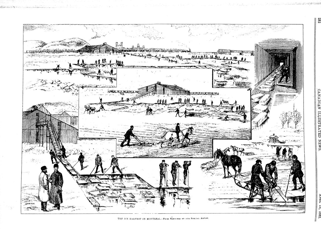
1882 Feb 4 About 400 men and 120 teams worked on the ice harvest. The total supply of ice cut was more than 75,000 tons, about 20,000 of which was stored for export by boat:
“The quantity harvested on the Don and Ashbridge’s Bay will therefore be greater than in any previous season.”[94] “Its quiet waters, noted for their purity, had become coated with a sheet ten to twelve inches in thickness, and when several American appeared on the scene and commenced harvesting the residents of the Lake Simcoe towns took the hint, ands some of them made thousands of dollars by the boom.” [95]
“The quantity harvested on the Don and Ashbridge’s Bay will therefore be greater than in any previous season.”[96]
“The remainder of the city’s supply will chiefly come from Ashbridge’s Bay and the Don. The ice of the latter, as may well be imagined, is exceedingly impure and is not used for drinking purposes. The breweries, butchers, and fish dealers use it in great quantities, owing to the convenience of obtaining it there.” [97]
“Work went on night and day when the markets were most favourable and signs of an approaching thaw made their appearance.” … “As much as $1,200 to $1,500 profit were made off ponds an acre or two in extent. Every available railway car was brought into service for the conveyance of ice, and yet a sufficient number were not to be had to meet the demand.”[98]
Frozen water had to be near railways to be valuable for the ice trade. [99]
1882 March 17 Ashbridge’s Bay ice men adamantly denied that Ashbridge’s Bay ice was impure.[100]
1882 May 31 In 1882 one man shot 33 ducks on Ashbridge’s Bay in about three hours.[101] Hunting, like fishing, was both a sport and a business. Wildfowl used the marsh as a staging area during spring and fall migration. Professional gunners shot geese, ducks and shorebirds and both market gunners and sportsmen shot prodigious numbers of birds. Hunters used dogs, wooden decoys (now collectors’ items) and blinds as well as punts specially rigged for extra-large shotguns. Even songbirds were not safe. Gunners shot swallows off the telegraph wires for sale at the St. Lawrence Market. Even naturalists shot birds.
1882 July 18 From early in the 1880s the question of annexation was a concern for residents of Leslieville who felt they suffered from a lack of adequate police protection and the “neglect of any sanitary precaution” (ie. well water, outhouses, and septic tanks only and no piped and treated water and sewers).[102]
1882 July 20 “Mr. W. Laing, the well-known fisherman, caught an eel yesterday morning weighing within an ounce or two of thirteen pounds.”[103]
1882 July 29 “Mr. John Ayre, of Winchester street, caught five very fine pike and four black bass, varying from 3 lbs. to 5 lbs. in weight, in Ashbridge’s bay early yesterday morning.”[104]
1882 Aug. 16 Torontonians were concerned about contaminated drinking water. They knew they needed better ways of disposing of human waste than dumping it in the ground or dumping in the water. Different schemes were proposed, all of which involved piping the waste further and further out into the lake to remove “all possibility of annoyance from the exhalations arising from sewage.”[105]
The hope was that the sewage would rot in the water and the fish would eat it Whatever was left over after the water had done its magic and the fish had their suppers, would settle to the bottom of the lake, harmless. The main sewage outlet was at the foot of Yonge Street in the 1880s, allowing the untreated waste to back up around the wharves and piers, where it just sat and sat. In the 1880s most of the human waste of Toronto was deposited directly into Toronto Harbour where it backed up into the slips and generally remained within 300 feet of the Esplanade. The desire to get rid of it as strong as the smell of the sewage.
In the daytime the Yonge-street sewer can be detected by the smell for only a few rods. At night of course, as along the whole water front at present, an offensive …odour will prevail… [106]
Ashbridge’s Bay would be the perfect place for the sewage to go:
The sewage, diluted and carried out by the Don into Ashbridge’s Bay, enters a large expanse of comparatively calm water, where deposition of offensive matter must proceed more rapidly than in the rough waters of the lake. After remaining in the bay generally for a long…a portion of the thoroughly diluted sewage will pass through Ashbridge’s gap into the lake…[107]
The City planned on putting the creeks that flowed into the lake underground in pipes, as sewers. The water pressure created by the flow of Garrison Creek, Russell Creek, Garrison Creek and others would carry the waste of the city downhill to the waterfront where an east-west main would carry it further along to where it could be piped out either into the Bay or the Ron River. The dilution of the waste would supposedly render it tasteless and, if tasteless, harmless.[108]
The thorough mixing of the sewage with the water takes place but gradually, and might not be completed before the bay would be reached. But there, at any rate, the sewage would become wholly deodorized on mixing with an expanse of 900 acres of water from six to twenty feet deep, and being constantly interchanged with the water of the open lake. Danger to the health of Toronto, or of annoyance to the noses of its inhabitants, is therefore not to be feared from the discharge of the city sewage into the Don and therein through the 313 million cubic feet of water in Ashbridge’s Bay into Lake Ontario.[109]
In the 1880s it was hoped that the market gardeners of Leslieville would be able to use much of the sewage sludge for irrigation of their sandy soil. Raw sewage could be pumped uphill and carried by a main sewer to the east end of Leslieville. Farmers could use it and the City of Toronto might even make a profit from its waste. Apparently, in Britain, raw sewage was being used for fertilizer at that time. Toronto could hope to do the same, if the costs could be bought down:
The average of twenty towns shows an acre of irrigated land for every 111 inhabitants. One ace to 150 inhabitants is the utmost extent to which it is advisable to carry irrigation. Toronto, with its present urban and suburban population of 100,000 would require 666 acres. The expense of preparing the land for irrigation has near several British cities exceeded £70 per acre. For many years to come, therefore, irrigation will not be resorted to in this country. Should it ever become desirable, a suitable sewage pump can be erected at the Don mouth.[110]
However, in the meantime there was always Ashbridge’s Bay:
Another, and much more feasible scheme, is the turning of the sewage into the marsh. To effect this a reservoir and pumping house would be requisite. As the elevation would not require to be great, a couple of engines, capable of meeting extraordinary requirements at times, would be necessary. The sewage could be conducted by pipes to any part of the marsh and there discharged into spaces enclosed by piles. [111]
If it worked for cow dung, it would work for human dung. The Globe even suggested that the street sweepings, ashes, and the like could go into the mix with the sewage. The street sweepings were being used to create landfill along the Esplanade, gradually moving the City shoreline south one garbage load at a time.[112]
1882 Nov. 5 Funeral for William Greenwood who died November 12, 1882 of typhoid fever. The funeral procession went from the home of his mother Katherine (Kate) on Kingston Road to St. John’s Anglican Church (Norway). He was a new A.F. and A.M. member and the Masons turned out in full regalia. “The deceased was a young man of great promise and his funeral was attended by a large concourse of sorrowing relatives and friends.”[113]
1882 Dec. 5 1882 East End Nuisances: There was growing concern over pollution from the extensive cattle byres at the mouth of the Don. Neighbours complained of offensive smells and “foul emanations” from the don River and that part of Ashbridge’s Bay. The GTR had pig pens and fat rendering facilities there. Manure went into the Don from the slaughterhouse as well. William Davies owned a huge pork packing establishment. Even though a nearby soap factory, was kept “wholesome”, it also contributed to the problem as did a tannery. It was clear, though, that the main culprit was the cow byres of Gooderham and Worts. The liquid manure run-off went into Brown’s Pond, part of Ashbridge’s Bay. Liquid manure ran off went into Brown’s Pond, part of Ashbridge’s Bay, forming pools of stinking shit.[114]
“The present putrid state of the banks of the Don and the bordering marsh, due to years of accumulated organic filth, is doubtless the cause of much of the foul odours which prevail in summer, and is certainly dangerous to the health of the community.” Signed by H. Sproat, City Engineer; E. Coatsworth, City Commissioner; W. Caniff, Medical Health Officer
These gentlemen stressed the need to find another way of disposing of sewage and supported a ban on factories that were dangerous to the public health. The solution, many believed, was a trunk sewer that would take the municipal sewage and industrial sewage six or seven miles east where it could be piped out into Lake Ontario. [115]
1882 Dec 5 Sewage treatment was an important local concern. As it was, the sewage of Toronto and its suburbs, including Leslieville, either went untreated directly into the lake, creeks or rivers, or seeped into the ground water from privies (outhouses) and septic tanks. Some people began to stress the need to find another way of disposing of sewage and supported a ban on factories that were dangerous to the public health. The solution, many believed, was a trunk sewer that would take the municipal sewage and industrial sewage six or seven miles east where it could be piped far out into Lake Ontario.[116] It was believed that the oxygen in the water magically purified the sewage without any help. Out of sight, out of mind – until the sewage-bred bacteria of typhoid and other water-born illnesses came back to kill.
1882 Dec 12 “It would seem as though many of the persons who have contracted for the principal ice-houses in the city have determined to take their material from the very foulest places…the concentrated essence of nastiness…”[117]
1882 Another storm increased the Eastern Gap to 4,000 feet. Construction began to stabilize the Eastern Gap for shipping.
1883 March 15 If sewage was a concern for Leslieville in 1884, so was water, fresh drinking water. Wells periodically went dry and were becoming contaminated as well:
Most of the wells in Riverside are empty of water. It would be a good thing for the inhabitants if they were now attached to the city, so that they may have more water to drink and more to wash with.[118]
1883 March 24 The Committee asked the City Council:
“to take measures for the removal of the cattle byres on the east side of the don. It is complained that through the existence of these byres the marsh is becoming nothing better than a cesspool, and Ashbridge’s Bay is rapidly becoming such a collection of filth that no fish will be able to live in it. There is also a strong opinion that the health of the neighbourhood suffers in consequence of the nuisance.[119]
1883 May 8 John McLatchie, blacksmith and a Orangeman, chaired public meetings held in Leslieville held to discuss the “Cattle Byre nuisance”. McLatchie, the blacksmith and prominent Orangeman, was chair.
“William Laing, the fisherman and boat builder, addressed the meeting. Laing said that if nothing was done about the contamination of Ashbridge’s Bay, people like him would have to sell out and leave.”
Martin McKee and other ice house owners agreed that something had to be done. Leslieville family physician, Dr. Kennedy stated that “the progress of the eastern suburbs was obstructed”. He clearly saw it as a health issue. Dr. Kennedy said that he had recently seen 400 dead pike in 460 yards of Ashbridge’s Bay. Others observed that pollution that year had killed fish in the Marsh.[120]
1883 May 17 Gooderham and Worts resisted, pulling every string, bullying, threatening and prevaricating. They claimed that “very little refuse matter flows into the marsh”. George Gooderham was rich, influential and virtually untouchable.[121]
1883 May 17 Local residents asked the City to make a cut to be made in the sandbar that formed the southern edge of the marsh. They hoped this would purify Ashbridge’s Bay by allowing fresh water to circulate in from the lake and polluted water to drain out.[122]
1883 May 17 Efforts have been made recently to have removed the cattle byres of Messrs. Gooderham & Worts, between the Kingston-road, the marsh, and Ashbridge’s bay, on the east side of the Don. It was stated that the marsh was being filled up with a lot of deleterious matter which came from the byres, but those in charge of the byres deny this statement. They say that very little refuse matter flows into the marsh. The byres are not used during the summer moths, as the cattle are taken in during October and they are removed by the middle of June, when the stables are thoroughly cleaned. During the time the byres are in use every precaution is taken to keep the place free from any accumulation of filth. Contracts are made with a number of market gardeners who reside in the vicinity of Leslieville for the removal of the manure each day. Between 150 and 200 loads of manure are hauled from the byres every 24 hours. The arrangement for flushing is very complete. Water is allowed to flow through the floors of the stables. The thirty men working at the byres are old hands, and have not, they say, found the work detrimental to health. The wages paid to the employees at this place amount to about $20,000 per annum.
A GLOBE reporter enquired from a number of inhabitants living on the Kingston-road as to the health of the neighbourhood, and every person spoke to said that in his opinion the byres were perfectly healthy. They all complained, however, of a meat-packing factory near the Don station, which almost sickened the inhabitants of both sides of the Don. [123]
1883 March 15 The raw cattle excrement from the Gooderham barns or byres on the shore of Ashbridge’s marsh (near the east side of the Don River) flowed by wooden pipes into the wetland. Several thousand cattle were kept penned there, fattening on the mash from the distillery. The cow manure filled the shallow ponds or lagoons in the marsh, creating a stench that blew into the City when the east winds blew. Gooderham and Worts responded by burying the “vast open cesspools”. The work went on for months. About 200 men with wheelbarrows trundled earth over wooden planks laid over the top of the quaking mass of cow dung. They covered the surface with about two feet of soil until it was strong enough, at least in many places, to be walked on although it quaked in wet weather, in some places, threatened to entrap the daring interloper in a disgusting “quick sand”.[124]
1883 May 22 Poachers sometimes found them up before a Magistrate’s court at the Leslieville Hotel answering to charges of breach of the Fishing and Game Laws.[125]
1883 Oct 18 John Jones moved that a committee be formed to approach City Council for “immediate action”. The Committee consisted of: Dr. Kennedy, George Leslie, Sr., J.P., J. Phillips, John McLatchie, Martin McKee, John Jones, Alfred Medcalf, David Hunter, William Laing, Henry Calendar, hotel owner, and J. Knox Leslie.[126]
1883 Oct 30. J.K. Leslie, clerk for York Township, led a delegation to Toronto City Council. Alderman Pape moved to allow J. Knox Leslie to address Council. He presented a strong argument for cleaning up Ashbridge’s Bay and stopping pollution. He argued that they City should ban all ice cut on Ashbridge’s Bay as the ice was so filthy that it was yellow. Dr. Kennedy then addressed Council, stating that “Ashbridge’s Bay was now nothing but a huge cesspool.” He argued that there were not two laws – one for the rich and one for the poor. Without saying the actual names, he stressed that Gooderham and Worts were not above the law. Kennedy complained that, compared to Riverdale, which was then a prosperous upper middle class suburb, Leslieville had seen little or no improvement. Leslieville had no gaslights and no sidewalks:
“Why was it? Because the people were poor; because few cared to live there on account of the nuisance [polluted bay] which existed.’ He spoke of the ice merchants, “Men had risked their all, and now for the sake of one large corporation, these men were to be ruined.” Alderman Davies moved a motion to refer the matter to the Committee on Health. The motion passed.[127]
1883 Nov 14 As well as wildfowl, local people trapped muskrat and beaver in Ashbridge’s Marsh. Muskrat-lined coats with beaver collars were prized. People of the day used the muskrat to predict the weather: “The muskrat houses in the vicinity of Ashbridge’s Bay are very small this season, indicating a short and mild winter.”[128]
1883 Nov 14 In a meeting of the Committee on Markets and Health, it was agreed that the bottom of Ashbridge’s Bay was covered with decaying manure and that the byres should not be allowed to dump manure any more. George Gooderham, owner of the distillery, addressed the meeting, arguing that the problem was not just his byres – others contributed to it too, probably more than his byres. He was not as bad as some others, he suggested. He also baldly threatened that, if his byres were forced out, then the distillery would go too and many jobs would be lost and over $20,000 a year in taxes to the City of Toronto would disappear with the distillery. The Mayor asked the Committee to inspect the byres.[129]
1883 Nov 19 The Committee of Markets and Health visited the cow byres and east end factories, including the Morse soap factory and Davies pork packing plant. George Gooderham and W.H. Beatty lead the Committee on a tour of the cow byres. Liquid manure from the byres flowed directly into the marsh. The more solid waste was carted off every day by market gardeners to use on their fields.[130] Given that the polluters were warned in advance, it is not surprising that everything was clean. However, the drainage of blood, offal and manure into the Don was a problem so obvious that it could not be totally ignored.[131]
1883 December 14, The committee of Leslieville property owners was disillusioned by City Council’s foot dragging and became convince that the City would do nothing for them and that they would have to turn to Ottawa and the Province.[132]
1884 most of Leslieville was annexed by the City of Toronto. One tangible measure of the advantage of belonging to the City was the construction of sewage mains. The City boasted of its sewage construction as a sign of progress.
1885 Leslieville men farmed in summer and cut ice in winter, making the best of the seasons.[133]
1887 Experiments in water filtration with sand at the Lawrence Experiment Station in Massachusetts.[134]
1887 Jan 1 The mileage of sewers in Toronto in January, 1883, was 81.22. By the addition of St. Paul’s Ward, 4.88 miles were added, while during 1883 there were constructed 9.67 miles of sewers, and during 1884 111.48 miles, making a total mileage on the 1st of January, 1885, of 107.25. Up to the end of 1885 and additional .75 of sewers had been constructed, making the mileage 115. During 1886 there was constructed 6.62 miles, making the total mileage 121.62. The following [Leslieville listings only included] sewers have been constructed during the past year:– Brooklyn avenue, Queen to north end. Pape avenue, Queen to railway track. [135] In 1886 the City’s progress was reflect in the laying of almost 48 miles of cedar block pavements and 121 miles of sewers. In that year cedar block was laid down on Kingston Road from the Don Bridge to Greenwood’s Lane, the City’s eastern limit.[136]
1888 March 3 property owners along a street were expected to pay for any improvement to that street. The cost was not spread out over the taxpayers of the whole city, but loaded onto the shoulders of a few on the grounds that those few were the chief beneficiaries of any improvement. In 1888 Local residents objected to having to pay for the extension of the Queen Street [Kingston-road was now called Queen Street] sewer east to the Toronto Nursery grounds near Pape Avenue. J. K. Leslie chaired the meeting at Poulton’s Hall to plan an appeal against the tax assessment.. Others thee included Martin McKee, W.B. Poulton, John McLatchie, Edward Blong, Ross Manson, H. Woodrow and J. Smith.[137]
1888 Thomas Davies and J.K. Leslie asked the City to cut a channel through “Fishermen’s Island” into Ashbridge’s Bay. It was hoped that this would wash away the e accumulation of manure and sewage. A committee of alderman was appointed to visit Ashbridge’s Bay and recommend improvements.[138] This committee, consisting of Ald. Drayton, Verral, Gibb, Morrison and Carlyle, was to visit the bay with the city engineer and report as to what is needed from a purely sanitary standpoint.[139]
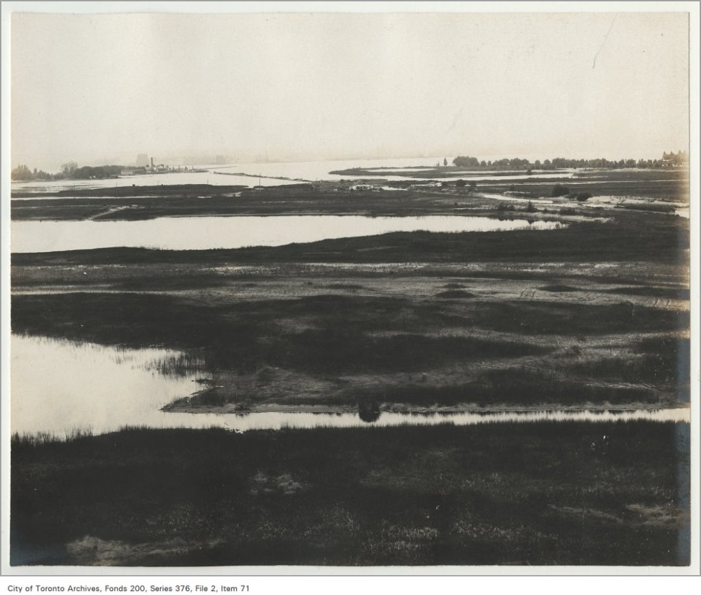
1888 September 8, the city commissioner escorted a party consisting of Mayor Clarke, and some aldermen, along with a Globe reporter, on a tour of Ashbridge’s Bay. The long-awaited channel was being cut from the bay into the lake.
“A heavy sea was rolling and an excellent opportunity was afforded of testing the stability of the work. The piece of land cut through was about 160 feet across, and the width of the channel is about 110 feet. Two piers run out into the lake … 60 feet, and the filling is done chiefly with cedar bark… Already the flow of water from the lake has purified the bay, and when the work is complete it is expected there will be no more complaint about the unsanitary conditions of the neighbourhood.”[140]
Charles Sheard was something of an expert on typhoid, writing articles, for example, for the Canadian Lancet medical journal. The germ theory was well established in the medical community by the last decades of the nineteenth century P. 356-357. The Canadian Lancet: A monthly Journal of Medical and Surgical Science, Criticism and News. Edited by J.I. Davison and Charles Sheard. Vol. XX. Toronto, Dudley & Burns, Printers, 1888.
1889 City Commissioner Coatsworth developed a plan in 1889 to “improve Ashbridge’s Bay by filling it in: “The scheme comprises sanitary and commercial improvement. It proposes to reclaim from three hundred to five hundred acres of land which are now covered with shallow water that ripples idly in the sunshine, with perhaps an occasional iridescent tint of sewage upon its playful surface.” [141] The plan include a canal to link the lake with an improved Don River and an esplanade.
1889 “ASHBRIDGE’S BAY
CITY COMMISSIONER COATSWORTH, who is favourably known by his past record as a man of judgment as well as a man of integrity, has originated a scheme for the improvement of the shallow lagoon known as Ashbridge’s bay which must commend itself to everyone who gives thoughtful attention to its features. The scheme comprises sanitary and commercial improvement. It proposes to reclaim from three hundred to five hundred acres of land which are now covered with shallow water that ripples idly in the sunshine, with perhaps an occasional iridescent tint of sewage upon its playful surface. It conceives the idea of cutting a canal capable of admitting lake-going craft, which shall not only communicate with the improved River Don, but which shall be the entrance to a flourishing esplanade in a place where railway companies shall cease from troubling, and respecting which the citizens may be at rest from alarms of encroachment.
The driving of this broad and deep channel through Ashbridge’s bay will perform incidentally the immense service of establishing a current which will not only purify the bay’s waters to an extent they have not known since the aboriginal bark canoe was frequently launched upon them, but will tend also to purify the not too sweet waters of Toronto harbor.
There are many people in Toronto who know as little of Ashbridge’s bay as they know of ASHBRIDGE. For their information it may be stated that whoever ASHBRIDGE was, the piece of mud and water he gave his name to, has not at present done much for Toronto. And certainly Toronto has not done much for the bay. It has simply served as a receptacle for the inflow of the gradually increasing volume of the sewage of the eastern end of the city. At length, as there was not flow or current through it, the water began to be offensive and insanitary, and last year, under the authority of the Board of Health, Commissioner COASTSWORTH cut a channel through the strip of land enclosing it at the east, into the open lake. The result of this, so far as it has gone, has been eminently satisfactory, and has resulted in a considerable purification of the stagnant waters. It has shown that if the proposed canal, running from east to west, be cut, there is a downright certainty that the improvement from a sanitary point of view will be enormous.
If citizens interested in the matter will take the map of Toronto they will see that the land inclosing the bay in question projects in a triangular shape from the general line of the city front, and that at the western end it there is an archipelago containing several islands and peninsulas of low-lying land. Commissioner COATSWORTH proposes to reclaim useful territory. The canal he proposes to cut will take a straight course parallel with the general line of the front of Toronto, and the improved River Don, at is junction with this canal, will take a bend eastward before it joins the new cut. The present devious course of the mouth of the Don to the westward will be left as at present. Thus a current will be established by the waters of the Don, which will flow eastward, and a current will be established by the waters of the Don, which will flow eastward, and straight out to the opening in the eastern end of the bay which was made last year, and which it is now proposed to enlarge and improve. The sides of the new canal will be strengthened with piling, and the sand dredged out in making the channel will be used to fill up the low-lying lands at the west end of the bay.
It goes without saying that the scheme is exceedingly popular at the East end, which will be immensely benefited by it. But the possible benefits of it are so great that it may well arrest the attention and engage the good will of the citizens at large. The fact is that Toronto’s advantages in the way of location have been so great that we have been rather careless of them until there has appeared some danger of their being curtailed. The project which we have thus briefly sketched opens a fresh field of enterprise which can be taken advantage of by the city at a very moderate outlay, and its merits, in view of our rapid extension and future probabilities, must cause it to be favourably entertained by every thoughtful mind.[142
1889 Sept 19 1889 The City Board of Works considered undertaking more up-to-date sewage treatment methods. A Major Mayne, agent for what is called the “Condor” system of sewage purification, tried unsuccessfully to sell the City fathers his technological solution. Others had sewage schemes as well, but the City dragged its feet, reluctant to undertake the expense involved in a modern sewage treatment system. A small test of the “Porous Carbon” system was tried in the basement of the City Hall, at a cost to the of $6,000 to $7,000, but not expanded to a wider application. By this time Garrison Creek was sewer in the West and trunk sewers dumped raw waste into the Don in the East.[144]
1890-1891 the European starling was introduced by a group whom, it is said, wanted to bring all of the birds mentioned in Shakespeare to North America. They released 100 starlings in New York City in 1890-91, the ancestors of millions spread across North America.
1890 [circa] I have seen thousands of Muskrat houses built in it at one time and am safe to say that as many as ten to twelve thousand rats would be taken in one spring….It was a problem catching Mud Turtles. The best way was undressing and taking a sack, walk in the water up to your armpits and when you stepped on a turtle you would duck under, get him, and put him in the sack [sic]. I have taken as many as seventy-give to a hundred in one day in this way and sold them in the market for turtle soup.[145]
1890 In the near future it is likely that the city fathers will try to undertake two jobs involving millions of dollars each. These are the running of a street railway system and the reclamation of Ashbridge’s Bay. There are in Toronto a certain number of cranks who want to run everything, when the past effectually bears witness to the fact that where aldermen are, no good ever results. For example, the Don Improvement scheme has given birth to a crop of law suits healthy enough to last a decade. And the work, on account of this, lies in an unfinished state. One thing is certain to sensible men—the Ashbridge Bay scheme should be carried out by a private company merely because such a sum is involved. And as for the Street Railway Senator Smith’s bob-tail cars are a luxury compared to what a civic committee would load on the people.[146]
1890s the City wanted to fill Ashbridge’s Bay with garbage.
Right up until the 1890s, sports fishermen preferred the sheltered waters of Ashbridge’s Bay to the open lake. As the Bay became more polluted apparently the fish stories grew more outrageous. In 1893, a newspaper warned: Apart from the moral influence of fish stories from Ashbridge’s Bay they will be detrimental to those who promote reclamation schemes on sanitary grounds. Great fish do not shoal in polluted waters.[147]
A number of factories, including paint factories, occupied the landfill and dumped coal tar, oil and other contaminants into the storm sewer system and Bay. Canada Paint, Leslie Street, sat on landfill just south of Eastern Avenue. It was a major employer as well as polluter from the early 1890s on. Major employers had power. The Bay was expendable. Toxic chemicals, including lead, cobalt, cadmium, arsenic and cyanide, contaminated the water.
1891 the first east end garbage incinerator, the Eastern Avenue Crematory was built. It burned down in 1892.[148]
1891 Sept 12 Ashbridge’s Bay.
Hon. C.F. Fraser, Commissioner of Public Works; Hon. A.S. Hardy, Commissioner of crown Lands, and Hon. J.M. Gibson, Provincial Secretary, received a municipal deputation at the Legislative building yesterday afternoon. Mayor Clarke, who acted as spokesman, was supported by Ald. Leslie, Bell, Pape, Allen, Hall, Macdonald, Burns and Hewitt, Engineer Jennings, Solicitor Biggar, Clerk Blevins and Assistant Littlejohn. Messrs. Beavis and Rodway and several property owners in the east end were also present. The mayor explained the condition of the bay, and claimed that it was imperative that something be done in the matter at once. He asked that the Commissioner of Public Works approve of the work proposed by the city. Hon. Mr. Fraser said that the title to the land directed that revenues derived from it should go to the support of the Queen’s Park.
The Province had now a greater interest than before in the park. The revenue was of great importance, and before giving a decision he would carefully consider the syndicate agreement with his colleagues. He would not object to any reasonable scheme of reclamation, but wished to consider the question of revenue. In reply to the city solicitor, Hon. Mr. Hardy said that if no revenue were derived from the land for 45 years there might be other commissars to deal with. On the suggestion of a property owner that the Legislature undertake the matter, Hon. Mr. Fraser said that the Dominion Government was the only central authority that carried on works of that nature.
After the Ministers had given a promise to consider the agreement at once Al. Hewitt and Leslie complained that the terms were so onerous that no syndicate would tender on them. Engineer Jennings flatly contradicted the statement, saying that the conditions were not as severe as those governing the construction of a sewer or other city contract. Hon. Mr. Fraser said he would not think of interfering with any terms that the city might choose to demand. He was only interest, officially, in the question of Provincial revenue. The deputation then withdrew.[149]
1892 Sep 28 By the 1890s there was greater understanding of the causes of cholera and, therefore, focus on prevention. A doctor estimated that there were 12,000 privy pits or outhouses in Toronto. Each contributed to the contamination of the water table, raising the spectre of cholera.
“The sewage question was of the greatest importance, and should be treated at once by the board [Provincial Board of Health of Ontario]. [Dr. Allen] advised the building of an intercepting trunk sewer, and said he though the introduction of a trunk sewer would do a great deal to obviate the danger arising from cholera. The board passed the following resolution upon this subject: — “The Provincial Board of Health desires to emphasize an opinion already expressed, that all privy pits should be abolished in every municipality in the province, as it regards these as a most potent factor in the spread of Asiatic cholera and other infectious diseases.”[150]
1892 Dec 25 1892 there occurred what the News called “a Christmas Day surprise for the citizens”. The conduit pipe bring drinking water in from the Lake under the Bay broke. A long section of pipe floated to the surface of Toronto Harbour. In 1895 the pipe broke again. Typhoid made the breaks in the pipe and the uncertain purity of the City’s water an urgent topic. A writer noted that the defects of the system at that time were numerous, and suggested that “the impure quality of the water frequently introduced into the houses and, necessarily, into all domestic uses–drinking, cooking, washing–demands immediate consideration…..The health of the citizens is of the first importance, and it is menaced by the unsanitary water.[151]
1893 The City began construction of the Keating Channel; it extended from Ashbridge’s Bay to Toronto Harbour and eventually formed the sole outlet for the Don River, diverting the original western channel.[152]
While discussions in 1893 were trying to address the problem of impure water, to quote nineteenth century historian Edwin Guillet:
“It is of interest here to note that a sewage disposal plant, then to be found only in a few great cities like London, England, was not seriously advocated, but was merely hope to keep sewage away from ‘the marsh at the mouth of the Don’ and from the Island, and to conduct it a mile or so out into the lake.”
1893 June 23 On a division it was decided, on motion of Ald. G. Verral, to delay action for two weeks until the estimates are passed. A sub-committee was appointed to consider what rent squatters on Ashbridge’s bay shall be required to pay. [153]
1894 Jan 18 Gooderham & Worts are shipping one hundred car loads of manure from the byres to their Oakville farm.[154]
1894 Jan 23 The ice dealers are watching and praying for more favorable weather for making ice. Many men who are idle, are also waiting anxiously for colder weather as in that event a good many would be employed cutting and storing ice for the summer.[155]
1894 Feb 14. Low paying and dangerous. Men and horses occasionally fell through the ice and drowned or lost their way in a sudden snow squall, to die of hypothermia. In 1894 a team drowned and the driver was lost in the storm. Thomas Finn wandered on the ice for hours and his hands were badly frost bit by the time he stumbled into Gooderham’s shanty at the west end of Ashbridge’s Bay.[156]
1894 Feb 20 the Woodbine Ice Company’s owner William Booth, nearly drowned while walking on the Bay on a Sunday. [Some of the Sabbath-loving people of Leslieville may have thought he was being taught a lesson.][157]
1894 March 7 “It is estimated, by those who know, that more ice has been cut and stored in the East End this year than in any former season.”[158]
1894 March 12 “A horse that was drowned some weeks ago in Ashbridge’s Bay has been allowed to remain in the shallow water and is beginning to decompose.” [159]
1894 March 12 “The Canada Paint Company will commence the manufacture of paris green for the coming season next week. A large number of men are at the company’s office almost daily looking for work.”[160]
1894 April 2 The attention of the authorities is directed to the unlawful way in which fish are being caught in Ashbridge’s bay. Several nets are stretched across the eastern and western cuts.[161]
1894 April 13 Seized Fishing Net
“Fishery Inspector Ward made a tour of Ashbridge’s Bay yesterday afternoon and seized several nets. He also secured with them splendid pike and many smaller fish.” [162]
1894 April 13 “The Ashbridge Cut
There is no reason to doubt that Engineer Keating selected the proper spot for the cut through the Ashbridge sand bar. The western jetty has not been completed, in fact it has scarcely been begun and not enough work has been done on it by Contractor Grant to aid in keeping the channel open, yet the channel is deeper today that it was when dredging was stopped last fall. The water flows through with quite a current and there is every reason for the belief that the problem of purifying the bay has at last been solved.”[163]
1894 May 1 “Since the new cut has been opened …[it] admits the lake perch and silver bass. Many perch were caught last Saturday.”[165]
1894 May 1 Gooderham’s grove on Queen street is being ploughed and will be seeded down and otherwise beautified.[166]
1894 Aug. 3 Although not scientists, the “water rats” of Ashbridge’s Bay made the connection between bad drinking water, typhoid and the health of the Bay. They fought for years against politicians refused to accept the germ theory. A local resident told City Council: “That’s where the microbes breed” and Alderman John Hallam replied, “Microbes? fiddlesticks.”[167] Toronto responded to the typhoid epidemic by building water filtration plants, using alum (aluminum) and chlorine to treat the water, after much grumbling about the cost.
1894 Aug 3 The Mayor claimed that as soon as the Keating Cut was made, Ashbridge’s Bay would be sanitary.[168]
1894 Aug 3 RAID ON THE CITY
That is What Certain East Enders’ Desires Mean
THEY WANT TO GET FREE LAND
Think the City Should Fill In Their Marshy Property
BUT THEY GET A DECIDED REBUFF
The wise men from the East came up to interview the Mayor this morning and to bring the tidings of what they allege to be a bad state of affairs at Ashbridge’s bay. The deputation was composed of ex-Ald. Leslie, W. Ablatt, Thomas Mitchell, C. Coleman, Mr. Greenwood and several others.
Those with the Mayor were Mr. Meredith, Mr. Keating, Ald. Burns, Lamb, Frankland, Hallam and Crane. The interview was at times a little warm and a few personalities were indulged in.
Leslie’s Complaint
Ex-Ald. Leslie charged that the city Engineer was remiss in his duty in not seeing that the contracts for the work in Ashbridge’s bay were properly carried out. The specifications, Mr. Leslie said, called for the depositing of the material taken out of the channel along the north shore. This, said Mr. Leslie, was not being done. The north shore was a mass of filth, the odor from which was very offensive. The sand and material being taken out of the channel was supposed to be used to cover up this filth and make good land.
Instead of that it was being dumped away out in the lake and wasted. The contractors, he contended, was bound to deposit this material on the north shore.
Mr. Mitchell spoke to the same effect. Mr. Coleman: “That’s where the microbes breed” Ald. Hallam: “Microbes? fiddlesticks.”
The Mayor Calls Leslie Down
The Mayor said he had refrained from calling Mr. Leslie to order, though he thought that it was very much out of place for him to come here and make an attack on Ald. Lamb.
Ald. Hallam thought that the deputation were very unreasonable. The city was doing all it could and spending a large amount of money in improvements of the bay. He claimed that the deputation represented only their own selfish interest, and the interests of the people generally in the ward.
Meredith Contradicts Leslie
Ald. Leslie again came back to the attack and said that the Engineers, the court and everybody know that the contract was not being carried out.
Mr. Meredith interrupted to say that that statement was not correct, and that Mr. Leslie must have been misinformed.
The Mayor read the opinion of Engineer Galt, as submitted to the court. This opinion was to the affect that everything was going on satisfactorily, and that the bay would be in a sanitary condition as soon as the channel was completed.
Mr. Keating, the Engineer, would have replied to the statements made, but Mr. Meredith advised him not to do so.
Accordingly the deputation had to be content with an assurance from the Mayor that the manner would receive most careful consideration.
Where The Rub Comes In The City Engineer states that thousands of loads of material that was fit to use for filling-in purposes has been used on the north shore, but it has been used to fill in the city’s property instead of that of private owners.
There has been a large amount of stuff dumped into the Lake, says the Engineer, that was not fit to use for any purpose of filling—in on the north shore.[169]
1894 Aug 3 Pike were the principal catch, but other warm water fish like catfish and bass were also caught.[170]
1894 carp came to Ontario when several breeders stocked a mill pond near Markham, and later one in Newmarket.
1894 Rowing Icemen Samuel Greenwood and Leonard Marsh defeated the brickmakers, championed by J. Grady and Sam Heale.
1894 Sep 7 At 4.30 o’clock this morning James Rivett, a waiter at Mcconkey’s, John Mimms, an employe of the Toronto Club, and B.O. Furey, 107 Bolton avenue, started out in a boat from the foot of Booth avenue for a morning’s shooting.
They were hardly clear of the bank when their boat ran aground on a shoal made by the dredging out of the western channel of Ashbridge’s bay and was overturned, the three men being preciptated into the water.
Furey managed to reach the shore and ran shouting for help up Bolton avenue.
Unable to Save Themselves
Weighed down by their heavy clothing the other two men sank to the bottom. Two young men who lived on McGee street, named George Platta nd Alex. Day, arrived a few moments too late and only succeeded in recovering the dead bodies.
Rivett is a maried man and lived at 52 Carr avenue.
The bodies of the two unfortunates were taken to the Morgue in the patrol wagon. [171]
1894 Sept. 26 sports fishermen preferred the sheltered waters of Ashbridge’s Bay to the open lake.[172]
1894 The City continued landfilling around the northern edge of Ashbridge’s Bay, creating more and more land out of ashes and rubbish each year.[173]
1894 Oct 18 “There has been a good deal of talk about what is best to be done with the marsh lands on Ashbridge’s Bay. Ald. Lamb, however, a short time ago, raised the question as to the city’s title to the lands being perfect, which resulted in the matter being referred to the City Solicitor for an opinion. That opinion has now been submitted, and it appears that the city’s title is hedged round with such reservations as to make the title of doubtful value.” [He recommended that the City buy the lands to get clear title.] [174]
From the late 1880s engineers formulated plans to create a new Toronto waterfront, but the Province of Ontario had claim on any land created there through land fill.[175]
1894 Oct 23 Large new ice houses were still being built including one by W. Booth and J. Russell at the foot of Morse street.[176]
1894 Sept. 26 sports fishermen preferred the sheltered waters of Ashbridge’s Bay to the open lake.[177]
1894 Nov 5 “ELECTRIC GARBAGE CARS
Reclaiming Ashbridge’s Bay May Bring Them Into Use Again
Ald. Burns and his Committee on Manufactures and sites were accompanied on their expedition to Ashbridge’s Bay on Saturday afternoon, by the Mayor, Ald. Shaw, Engineers and a number of aldermen.
All expressed their surprise at finding so much already done, and so much land available as sites for manufacturing purposes, providing access by a good roadway is given to the land.
It is probable that as a result of Saturday’s visit, another move will be made for having all the ashes refuse of the city convey by electric cars down to the marsh. Mr. Jones says that from five to ten acres could in this way be filled in each year.” [178]
Commissioner John Jones reclaimed from five to ten acres a year on the north shore of Ashbridge’s Bay. Streetcars hauled ashes and other refuse along Queen Street East, turned south at Logan Avenue and into Ashbridge’s Bay on a light rail line.[179]
1894 Dec 7 “Mrs. Anderson, wife of Robert Anderson, of Pape avenue, died this morning. Deceased had been sick about ten days, but her friends had no idea that her illness was so serious. …A large number of people in the East End have been taken ill during the last two or three days. The cause is attributed to the bad condition of the water.”[180]
1895 Jan 18 “This is clearly against the law and the police have it in their hands to seize the nets and punish the offenders.
Some years ago large seizures were made, thousands of yards being taken, but the spasmodic efforts of the police resulted in little good.
The Fisheries Inspector has not been seen in the neighborhood for a year.”[181]
1895 Jan 21 1895 Mayor Kennedy’s inaugural address touched on issues near and dear to East Enders. “I direct your attention to the fact that a large district of the city lying to the north of Gerrard street and to the east of the River Don is insufficiently supplied with water for fire protection and that it is advisable that that district should be cut off from the present low service system and added to the high level water supply.” He discussed the cottages on Fishermen’s Island and Toronto Island: “The renewing of such Island leases as it may be necessary to renew should be under very careful conditions, and every inch of the ground required for our ever-increasing population must be preserved. These remarks apply with equal force to the eastern Island or sand-bar, where already a number of summer residences have been erected.” Police protection was a hot issue. “I desire to point out that the police protection is not so complete as it ought to be, and that there are many districts in the city where life and property are not afforded the security to which those residing in the locality are justly entitled.” He called for an increase in the number of police officers. He also was concerned about children working, “It is patent up to all who take note of these matters that there are far too many boys and girls, who ought to be at school, running wild on the streets. There are, too, in my opinion, many boys under age at work before they have completed the most elementary course of education. This ought not be. Boys, also, are put in charge of horses, and even machinery, when far too young to have proper control of either, with the result that serious accidents occur, ending in injury and even death, which might be avoided if such young lads had not been so employed.”[182]
1895 Feb 7 1895 Land filling gained some sites for industry, but plans stalled due to the expense of a sand pump and the lack of clear title to the land.[183] These smaller land fill operations extended the shore at the foot of Leslie and west towards Carlaw Avenue.
1895 Mar 5 Concern mounted about the quality of Toronto’s water, including the cutting and storage of ice from Ashbridge’s Bay. The Medical Health Officer inspected the cutting of ice. The cost for these inspections was $20,000 in 1895. [184]
1895 Oct 14 ASHBRIDGE BAY.
THE ENGINEER AND THE HEALTH OFFICER DIFFER ON A QUESTION OF PUBLIC POLICY.
Accompanying the report of the Engineer to the Board of Works this afternoon, is one from Dr. Sheard on the proposal to deepen the channel from Ashbridge’s Bay to the Lake, and also as to the proposal of the Engineer to deepen the channel from Leslie street to connect with the present cut into the Lake.
On the latter part of the proposal, the Doctor and the Engineer take direct issue with each other, Dr. Sheard holding that the extension from Leslie st., would destroy the Bay as an ice field for domestic purposes.
The Engineer does not deny this but says that he is considering the question of improving the Bay as a whole, and not with any special reference [sic] to the quality of the ice.[185]
1895 Nov. 19 TORONTO’S REPUTATION
The bursting of the conduit injured Toronto’s reputation as a resort for tourists and health-seekers of other countries besides those of this continent. The last edition of the British Medical Journal, the standard of publications of the profession, contains the following: “Waterborne Typhoid at Toronto. A typhoid fever epidemic is threatened in Toronto. Some time ago the water conduits burst, and since that time the city has been without pure water. The effect is now apparent from the returns of the local Board of health. For the first fifteen days of the present month 77 cases of typhoid fever were reported, against 29 in the whole month of October last year, and 27 cases in October, 1893. There are a large number of patients at the different hospitals: At Grace hospital there are 36, at St. Michael’s 22, and at the General 40 cases.” [186]
1895 Nov 19 The British Medical Journal, reported: “Waterborne Typhoid at Toronto. A typhoid fever epidemic is threatened in Toronto. Some time ago the water conduits burst, and since that time the city has been without pure water. The effect is now apparent from the returns of the local Board of health. For the first fifteen days of the present month 77 cases of typhoid fever were reported, against 29 in the whole month of October last year, and 27 cases in October, 1893. There are a large number of patients at the different hospitals: At Grace hospital there are 36, at St. Michael’s 22, and at the General 40 cases.”[187]
1896 A dam burst in 1896, accidentally releasing the carp into the Rouge River and Lake Ontario.[188] Carp, alien to Canada, caused and still cause considerable damage to wetlands.
1896 The last wild Atlantic salmon in Ontario was recorded in 1896.
1897 Feb 13 Two east end milk dealers were called before Magistrate Denison and charged with storing using ice from Ashbridge’s Bay in a building not approved of by the Medical Health Department and without even notifying the department. John Leslie, 40 De Grassi street, and Robert Buckner, 17 De Grassi street, used a shed to store ice in. Leslie was found not guilty, not being connected with the offence in any way. Buckner was fined $10 and costs or fourteen days’ hard labor.[189]
1897 June 9 An application from the Queen City Bicycle Club to have Catfish pond made into a recreation ground was not entertained. Ald. Leslie said they might as well talk of fill up Ashbridge’s Bay.[191]
1897 Sep 1 Eventually it was made illegal to fish with nets in Ashbridge’s Bay. In 1897, Thomas Ellwood, an East End fisherman, pleaded not guilty before Magistrate Denison to a charge of illegally using a net in Ashbridge’s Bay.[192]
1897 Sep 30 Dr. Sheard researched various sewage treatment processes. In Hamilton the City used a system where sewage was pumped through a series of settling tanks and the effluent chlorinated. The sludge was then deposited in a vat, compressed, and sold by the City as fertilizer.[193]
1897 Sep 30 TO PURIFY SEWAGE
Dr. Sheard returned yesterday morning from Hamilton after an examination of the process of sewage purification which is being tested in that city. The doctor brought back with him a very favourable opinion of the system, which he says is simply a modification of the method in use in Birmingham, Eng. It consists of pumping sewage through a series of tanks and treating it on the way with chemicals. The effluent which is eventually discharged is said to be pure water, but of this Dr. Sheard would like to make certain by analysis before speaking authoritatively on the matter. The residue of the sewage is deposited in a vat situated under the tanks, pumped up from this, compressed, and then given away as a fertilizer. The doctor thinks the system might be tried on one of the Toronto sewers, either the Garrison creek sewer or the Rosedale sewer, and then if found satisfactory extended over the whole sewer system of the city.
The only rational way to deal with sewage, said the doctor, is to purify it, either by filtration or chemical process, and Toronto will have to adopt some such system before many years.
The trunk sewer scheme he condemned entirely, giving it as his opinion that sewage should never be allowed to pollute water.
The doctor will have a consultation with the City Engineer over the sewage question, and it is likely that in a few weeks they will submit a joint report on the subject to Council.[194]
1898 the city laid a 72-inch steel intake pipe almost one half mile out into the lake.
1898 …the capital city of Ontario, is situated on the north shore of Lake Ontario, about forty miles east of the western end of the lake, in Lat. 43 ø 39 • 35″ N., Long. 79 ø 23 • 39″ W. The lake is at this point about 240 feet (Harbor Commissioner’s gauge, zero, 244.8) above sea level.
The topography of the city and the country surrounding it is peculiar and a review will aid in understanding the ornithological conditions. The city for a greater part of its width is protected from the lake by a sandbar and island, once continuous. The sandbar runs west from near the eastern city limits for nearly three miles till it is divided by the Eastern Channel, and sending a spur north encloses what is known as Ashbridge’s Bay. This is really a marshy lagoon of considerable size, and though filled in, in places, still affords food and shelter for many species of birds. Into this bay originally drained some eleven creeks, and at its western end the River Don, which now is confined to an artificial channel and flows into Toronto Bay somewhat further north than where the original outlet of Ashbridge’s Bay was. The narrow sandbar that divides this bay from the lake is an important feature in the ornithological history of Toronto. It has been divided by an artificial cut giving access to the lake; the western portion is known as Fisherman’s Island, and from here as well as the bay itself have come many unusual records. The building up of this portion of the bar with houses has seriously affected the freedom of several species of waders, which no longer call here on migrations.
From the Eastern Channel, Toronto Island runs in a westerly direction for nearly three miles, till about two miles south of the city, then turns north towards the city, giving the island a more or less triangular shape, and ending in the Western Sandbar, which is divided from the city by the Western Channel, the original outlet of Toronto Bay, which is itself enclosed on the south and west by the island, and on the east by Ashbridge’s Bay. The island, originally covered with pine, has been invaded by sand, and for many years was very nearly treeless; it is deeply cut into from the bay side by many marshy lagoons and channels. Of late years a good deal of filling in has been done; many houses have been built along the lake front, and the planting of willows and other soft-wooded trees, particularly at Island Park, has given shelter and increased the food supply, inducing many birds to stop here on migrations that formerly passed over the city; warblers such as the Cape May, the Tennessee, and the Connecticut, that were regarded as accidental, have become regular migrants.
Toronto Bay itself has suffered from the sewerage poured into it and several species of aquatic plants that afforded food for wild fowl have been killed out, but some ducks, such as the Long-tailed Duck or Cowbeen, have found the conditions not unfavorable, and in winter whenever the ice allows, resort to the sewers in considerable numbers. These sewers now represent some six or seven small streams that formerly emptied into the bay from the north.
From the Western Channel the city runs along the open lake for three miles to the western city limits, following the inward sweep of the lake, which forms what is known as Humber Bay, the Humber River flowing into its western end about three quarters of a mile further on. Westward along the lake, Mimico Creek, the Etobicoke River, and, west again, the Credit River enters the lake, at a point thirteen miles from the center of the city.
Returning again to the city, the land rises gradually from the water front for some two and a half miles, and at North Toronto is 160 feet above the lake. From here an ancient lake margin rises abruptly some 70 feet to a plateau which sweeps across the back of the city and is broken only by the valley of the Don on the east, and the Humber on the west, and a few small ravines; a good deal of wood remains along this rise. This ancient water margin is one of a number (said to be thirteen) that exist between here and Lake Simcoe, some 60 miles further north; the highest point, 26 miles north of the city, near King, is 780 feet above Lake Ontario; it then declines till at Allendale on Lake Simcoe it is only 493 feet.
The shores of Lake Ontario about Toronto are low except on the east, at Scarboro (nine miles from the center of the city), where the land rises to 324 feet above the lake, and forms precipitous cliffs along the shore for some distance. Highland Creek and the Rouge River flow into the lake east of this point.
Toronto had originally many small ravines, through which flowed the streams that emptied into the water front. Most of these ravines are now filled in; in the northeast part of the city, in what is known as Rosedale, ravines of considerable depth exist and cross the back of the city to the valley of the Don; to the west of the city the ravines are not so numerous, though there are several between the western city limits and the Humber. This river and the Don run for some distance through flats between high banks.
Originally the city was covered by dense forests, and is so described in the early surveys (the first survey was made in 1793). Much of this timber was pine and hardwood mixed, but there were tracts of solid pine. This pine has long disappeared, only a stick remaining here and there on the ridge behind the city. There is much second growth pine and hardwood, and in the ravines outside the city some of the original forest remains. There are many wild places still remaining where forest birds may find suitable breeding places. In the city the streets are very generally planted with shade trees; there are many trees about the houses, and in the parks and open places there is plenty of shelter and food for birds.
A list of the birds recorded from the north shore of Lake Ontario would include only five species not given here; of these the Whooping Crane and Magpie are accidental; the Prothonotary, Golden-winged, and Hooded Warblers will eventually be taken here. It has been thought better to confine the list to the most important migration point on the lake, and to a place that has been the most carefully worked.
Toronto lies directly in the path of a great migratory route equidistant from the Atlantic, the Mississippi, and James Bay. There is strong presumptive evidence that two lines of flight converge, if not cross, here, one passing west through the Great Lakes, the other north towards Hudson Bay.
In preparing this paper I have traced all the unusual records back to the original specimens, and in all cases, except where mentioned, I have compared local specimens of every species recorded.
The migration dates given are based very largely on specimens, and in the ease of the waders exclusively so; consequently many of the dates are well within the mark, and can no doubt be extended.
I have not thought it wise to give the average date; the amount of material is not sufficient, and in any ease unless the records are made continuously in one place the results are misleading. In giving the dates between which a species has been found here, I have used those that have occurred more than once, and those that stand alone have been given as earliest or latest as the case may be.
From a very early period in the city’s history there has been a more or less active interest taken in natural history, which has resulted in two or three collections of birds coming down to us, whose history is well known, and which give a very good idea of the ornithological conditions between 1840 and 1850. Of these the collection made by the late Hon. G.W. Allen was the largest and contained about 145 species. To the influence of Dr. Wm. Brodie we owe the formation of a small society which published its reports in the’ Proceedings of the Canadian Institute’ from 1889 to 1891, and afterwards printed four numbers of the ‘Biological Journal of Ontario’ in 1894; these reports I have used largely, also the collection made by the society at that time. Mr. J. Hughes Samuel has allowed me to use his collection and records; the latter are of great importance as they cover a number of years of continuous collecting at Toronto Island, and I have particularly used them to correct my warbler dates. Mr. John Maughan, Jr., has allowed me to examine his large collection of mounted birds, part of which is now in the Provincial Museum, and I have found much useful data, particularly among the larger birds. I have also examined many rare records in the collection of Mr. J. H. Ames; Jr. C. W. Nash has allowed me to quote a paper published in ‘Forest and Stream’ (Vol. 38, 1892, 77) on ‘Shore Birds Near Toronto,’ and I have based many wader records on specimens taken by him. There are many mounted birds in the possession of sportsmen in the city, which have also been examined. My own collection of Toronto birds is a considerable one, and this paper is largely based on it.[195]
1898 March 11 For A New Park
Ald. Lamb Prophecies That the Sand Bar is to Become a Fashionable Watering Place.
Marchment & Co. asked for a strip of marsh land south of the channel at Cherry street, but Ald. Lamb led a successful fight against the firm. He said the land south of Ashbridge’s Bay was destined to become a fashionable watering place and produced a letter from Mr. Bertram, M.P., that the Government had granted the city permission to lay a sidewalk along the breakwater.[196]
1898 Oct 18 The experts of 1898 were divided on whether the City’s garbage should be dumped, preferably in Ashbridge’s Bay, or incinerated in a “crematorium”. According to the Toronto Star, most favoured continuing to burn Toronto’s trash. Even medical men did not see the connection between garbage and disease. Local family doctor, Dr. Cleland (730 Queen Street East), said, “No, I cannot say that I should apprehend any serious results affecting health from the dumping of the garbage in the bay, providing it is buried.” Local druggist, F.T. Burgess (Queen Street East) felt “The dump would not be nearly so bad a nuisance nor so dangerous as is the marsh itself.” He wanted the marsh filled in: “I am willing to take my chances so long as they will but fill in as fast as they can.” Some, however, feared the health impact of dumping garbage in a wetland. People were dying of waterborn illnesses, and people made the connection between bad drinking water and the health of the Bay. Dr. J. C. Carlyle (235 Seaton Street): “I don’t believe in carrying garbage from my back door to put it at another man’s back door. That is what it would amount to. The more stuff of that kind there is burnt, the better and safer it is. Decomposing garbage is always dangerous. I went down there this summer, and the stuff they were putting down there was most offensive.” Druggist A.E. Walton said: “I should be inclined to think it would be very dangerous.” Dr. J. B. Frazer (655 Queen Street East) felt that burning was better as it reduced the risk of contagious disease. Dr. McDonald (655 Queen Street East) believed that “the dump will not be conducive to health.” He went on, “I cannot understand those who say that such a large mass of decaying organic matter would not be a menace to health. It must create the germs of disease.”[197]
1898 Dec 14 the Canadian Club held an open forum at the YMCA. 40 people were there, including six women. Dr. Charles Sheard spoke about Toronto’s sewage problem and the need for a modern disposal system which would “be the saving of the harbor”. He believed that sewage disposal was Toronto’s most important problem. Infrastructure, roads, water and drainage were the foundation needed for Toronto’s growth. Sheard described the three methods of sewage disposal available at that time: Precipitation used a series of tanks to purify the water. A precipitation system would require 30 to 40 tanks to handle Toronto’s daily output of 15 million gallons of sewage a day. Filtration through and gravel beds was another method. An old method was the use of raw sewage and dried sewage (sludge) in farming, particularly market gardening: “the excrement and waste productions contained in sewage were necessary to the maintenance of the fertility of the land”, according to Sheard. With any one of these methods a trunk sewer system was necessary. Sheard favoured the last two methods. The City could no longer afford to drag its feet. The alternative was inviting epidemic disease. “Otherwise, he said, some one would some day take action that would make the municipality do something in a hurry, and what was done in a hurry was never well done.”[198]
1898 the city laid a 72-inch steel water intake pipe almost ½ mile out into the lake, to protect water supply.
1900 a typhoid epidemic swept Toronto. Toronto responded by building water filtration plants, using alum (aluminum) and chlorine to treat the water.
1900 Some Leslieville rowers became star athletes much as hockey or baseball players are today. Leslieville had the Leslieville Rowing Club. Toronto Island’s Ned Hanlan is better known, but Leslieville’s Hugh Wise, Isaac Price and John Russell, and brothers, Robert and Harry Dibble, were rowing celebrities as well. On Sunday afternoons dozens of rowing sculls dotted Toronto Harbour and Ashbridge’s Bay. Leslieville’s brickmakers and icemen competed against each other in an annual race.
The Bay was polluted, but so were the ground water and the streams running into the Bay. Everyone agreed that the Bay was a problem to be solved, preferably without drawing too much on the local taxpayer. Some wanted the City, Province or Federal Government to take charge of filling in the Bay, a massive and expensive job. The icemen denied that their ice was impure even though it was brown or yellow and smelled as foul as it looked. In 1900 icemen were still building new ice houses as concern mounted.
1901 April 3 In 1901 the foot-wide water main that crossed the Don River at Gerrard Street broke, cutting the supply of water to the East End in half. Another 12-inch main at Eastern Avenue and a 6-incher at King Street supplied the East End until repairs were made.[199]
1901 A wolf was reported in Leslieville, although it was probably a coyote. “Residents of East Toronto claim to have seen a large animal that resembled a wolf in the vicinity of Woodbine avenue. One man came in contact with the animal, and two dogs with him attacked it, and a fierce fight ensued.[200]
1901 July 31 Fishermen were complaining that the carp was ruining Toronto’s waters, saying they are “Not of much use to eat and the cause of much filth generally.” The carp feed on the bottom, roiling the sediments, making the water murky. Hector McDonell, resident of Fisherman’s Island, and fisherman for 30 years on Ashbridge’s Bay, said, “This fish is not a dainty little fellow, but coarse in appearance and coarse eating. He has a head like a bass and a mouth like a sucker.”[201]
1903 March 2 Garbage collectors from the East End signed a statement stating that used mattresses from the Isolation Hospital were being dumped into Ashbridge’s Bay. Street Commissioner John Jones called them up before him and chastised them for “whistle-blowing”. He demanded that they explain “how it was that they had taken upon themselves the liberty of giving out information without consulting the head of the department.” “I’m going to run this department of know the reason why,” stated Jones.[202]
1903 March 23 The City buried the lower reaches of Hastings and Leslie Creeks in combined sewers that also carried human waste. The heavy industry around Morse and Carlaw dumped coal tar, oil and other contaminants into the sewer. The paint works in the area were also responsible. Canada Paint, Leslie Street sat on landfill just south of Eastern Avenue. The shore along Ashbridge’s Bay at the foot of Leslie and west of there had a number of paint works who were dumping waste into the storm sewer system. With the creeks diverted into sewers, the little coves at the mouth of Leslieville’s Creeks had become pools of stagnant muck, covering the boats with “a slime that takes more than elbow grease to remove.” The Gut, once so good for fishing, was now “an open cesspool”.[203] Leslieville fisherman and others who had boats and boat houses on Ashbridge’s Bay complained that the outflow of the Morse Street sewer was fouling their property with coal oil and tar.
1906 contracts were awarded for laying sewers on Gerrard Street and Eastern Avenue.[204]
1906 By the turn of the century, trained observers were noticing that changes in the habitat of Ashbridge’s Bay were having an impact on the marsh wildlife. An ornithologist James Fleming reported:
The topography of the city and the country surrounding it is peculiar and a review will aid in understanding the ornithological conditions. The city for a greater part of its width is protected from the lake by a sandbar and island, once continuous. The sandbar runs west from near the eastern city limits for nearly three miles till it is divided by the Eastern Channel, and sending a spur north enclose what is known as Ashbridge’s Bay. This is really a marshy lagoon of considerable size and, and though filled in, in places, still affords food and shelter for many species of birds. Into this bay originally drained some eleven creeks, and at its western end the River Don, which now is confined to an artificial channel and flows into Toronto Bay somewhat further north than where the original outlet of Ashbridge’s Bay was. The narrows and bar that divides this bay from the lake is an important feature in the ornithological history of Toronto. It has been divided by an artificial cut giving access to the lake; the western portion is known as Fisherman’s Island, and from here as well as the bay itself have come many unusual records. The building up of this portion of the bar with houses has seriously affected the freedom of several species of waders, which no longer call here on migrations.[205] The topography of the city and the country surrounding it is peculiar and a review will aid in understanding the ornithological conditions. The city for a greater part of its width is protected from the lake by a sandbar and island, once continuous. The sandbar runs west from near the eastern city limits for nearly three miles till it is divided by the Eastern Channel, and sending a spur north enclose what is known as Ashbridge’s Bay. This is really a marshy lagoon of considerable size and, and though filled in, in places, still affords food and shelter for many species of birds. Into this bay originally drained some eleven creeks, and at its western end the River Don, which now is confined to an artificial channel and flows into Toronto Bay somewhat further north than where the original outlet of Ashbridge’s Bay was. The narrows and bar that divides this bay from the lake is an important feature in the ornithological history of Toronto. It has been divided by an artificial cut giving access to the lake; the western portion is known as Fisherman’s Island, and from here as well as the bay itself have come many unusual records. The building up of this portion of the bar with houses has seriously affected the freedom of several species of waders, which no longer call here on migrations.[206]
Toronto Bay itself has suffered from the sewerage poured into it and several species of aquatic plants that afforded food for wild fowl have been killed out, but some ducks, such as the Long-tailed Duck or Cowbeen, have found the conditions not unfavorable, and in winter whenever the ice allows, resort to the sewers in considerable numbers. These sewers now represent some six or seven small streams that formerly emptied into the bay from the north. [207]
1906 contracts were awarded for laying sewers on Gerrard Street and Eastern Avenue.[208]
1907 the Ashbridges began to divide their estate into lots for residential building.
1908 Jan 20 Around 1908 the economy was in a depression. A local resident suggested that the City built a spur line into Ashbridge’s Bay and build sewers, particularly Leslie Street sewer, to provide work unemployed men.[210] 1908 April 2 “The cottages upon the sand bar presented the appearance of a street in Venice, standing as they do upon posts buried five inches in water.”…[211]
1908 Oct 17 City Council passed a by-law to expropriate property to construct the sewage disposal plant east of Morley avenue (road). 62 properties were to be bought or expropriated and 45 houses were to be moved or torn down. The only politicians who voted against it were the aldermen from the local ward, Ward One.[212]
1908 Oct. 17 Property owners threatened to due the city if the sewage treatment plant was built. City Council passed a by-law to expropriate property to construct the sewage disposal plant east of Morley avenue (road). 62 properties were to be bought or expropriated and 45 houses were to be moved or torn down. The only politicians who voted against it were the aldermen from the local ward, Ward One. The City received a legal notice on behalf of East Toronto property owners who “claimed that if the disposal works were established on the Morley avenue site it would be a breach of an agreement between East Toronto and the city whereby the city agreed not to foul the lake and beach in front of East Toronto by sewage disposal from the city’s sewage system.”[213]
1908 As was noted at the time, “the present plans cannot be changed without tremendous expense to the citizens, and it would seem absurd for the Assessment Commissioner to purchase the property in Morley avenue if the controllers have any intention of changing the site. It is a rather serious question to take up just before a municipal election when appreciation of office leads even the strongest men to bend to popular demands.[214]
1908 Dec 14 The Beach residents were particularly opposed to the sewage treatment plant. Members of the Kew Beach and Balmy Beach Associations met a number of times to plan a campaign. They were not fooled by City claims that the plant would not smell, that the water would be pure, that the Beach would be safe, that it would be pretty. T. Aird Murray argued that, “Septic tanks could not completely purify sewage, and should not be erected in the vicinity of dwelling houses.”[215]
1908 Dec 21 The Mayor wanted the plant built south of Eastern Avenue, away from the houses and stores on Queen Street. “No matter where you put the septic tanks there will be opposition but I think a good deal of the opposition would be removed if they were located south of Eastern avenue.” The mayor’s proposed changing the course of Eastern Avenue by moving it north about 100 feet to encompass most of the originally-planned sewage plant site, making it still south of Eastern Avenue but without requiring much change in the plans. The bend in Eastern Avenue can be seen today.[216]
1909 Jan 20 CREATE HARBOR BASIN IN ASHBRIDGE’S BAY
Ald. Church’s plan for a new land-locked harbor in Ashbridge’s Bay will be discussed at a meeting of the Riverdale Merchants’ Association on Friday night at 8 o’clock in the Royal Canadian Bicycle Rooms, Broadview avenue.
It is proposed to dredge Ashbridge’s Bay into a large canal basin of new harbour, and widen and deepen Keating’s cut and the east end of Toronto harbor.
Docks and elevators would be erected. The city will be asked to put No. 3 and No. 4 dredges at work. Engineer Sing, Harbormaster Postlethwaite, and Wm. Evans, dominion steamboat inspector, approve of the plan.[217]
1909 Feb 27 The City did not back down. The City moved ahead despite the protests of residents. The land was purchased. The deal was done.[218]
1909 March 4 Experts from the City tried to defuse local anxiety: “Experts say the place will be a pretty park. (The Main Sewage Treatment Plant Park sits on the sewage treatment plant site today, being a flat featureless park, soggy underfoot most of the year.) Engineers, representing the City met with a deputation of representatives from the Beach Protective Association and the Riverdale Business Men’s Association. Riverdale, Leslieville and Beach residents fought against the construction of the Morley Road Sewer Treatment Plant. Property owners threatened to due the city if the sewage treatment plant was built. Residents feared that the proximity of the plant would destroy Woodbine Beach: “That part of the shore east of the Woodbine is practically the only beach where the people can bathe.” W. L. Edmunds said Beaches residents were opposed to the Morley avenue site: “The Beaches were growing rapidly and were residential. The district was looked upon as one of the best and healthiest parts of the city.” The Morley Road Treatment Plant would consist mainly of septic tanks. Edmunds feared that the proximity of the plant would destroy Woodbine Beach: “That part of the shore east of the Woodbine is practically the only beach where the people can bathe.”[219]
1909 Sep 3 SLAUGHTERING INSECTIVOROUS BIRDS.
The destruction of insectivorous birds about Toronto is an evil that has attained serious proportions. The men who have become habitual lawbreakers laugh at the idea of the local fish and game inspector interfering with them. The law has become to them a joke. They can be seen along the sandbar south of Ashbridge’s Bay with pockets or small baskets filled with swallows, an occasional bittern or herring gull supplying variety. Such unprotected birds as English sparrows and grackle are also shot, but the crowd of gunners make no distinction. On the first day of legal shooting the swallows were flocking large numbers along the sandbar, resting compact lines on the wires over the breakwater…on the wave-washed pebbles of the shore…slaughtered in large numbers by a nondescript crowd using all kinds of more or less effective shotguns. In many of the “bags” carried away from the marsh and bar swallows predominated, but there were a few plover and sandpipers to give a semblance of sportsmanship. This is the natural result of appointing inspectors who neither know or care anything about fish or game, and seldom visit the localities where such infractions of the law are likely to occur.
At other times the same destructive shooters make their way up the Don valley, killing indiscriminately the robins, shore larks, meadow larks, woodpeckers, and even song sparrows, goldfinches, and warblers. While their depredations there are restricted through regard for the local constable, they destroy many insectivorous birds every year. The seriousness of such destruction is now so generally recognized that some effective effort at repression should be made. If the balance of nature is freely disturbed insects will multiply unchecked and become a menace to the leading productive industry of the Province. The millions lost through insect pests in countries where bird life has been destroyed need not be cited, for the lesson has been deeply impressed. The law is as comprehensive as anyone could require. What is wanted is a serious attempt at enforcement, and at present there seems but little prospect of that. The lawbreakers know when enforcement is lax and improve their opportunities.[220]
1909 Dec 7 Some of the land purchased for the sewage treatment plant was not needed and became a park on the east side of Woodfield Road, and south of Queen Street, now the Jonathan Ashbridge Park.[221]
1909 In 1909/10 the sewage plant was built on Eastern Avenue at the foot of Morley Street.[222]
1909 The Rev. John Doel, who died in 1909 at the age of 93, remembered his “boyhood days [when] sea salmon were sometimes caught in the [Don] river.[223]
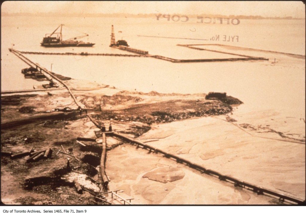
1911 Ashbridge’s Bay was a huge marsh badly contaminated with sewage and industrial waste. At that time, the port was busier than ever and looking for a place to expand. Ashbridge’s’ Bay was thought to be beyond redemption, conveniently for those wishing for industrial sites. At that time, Toronto’s port was busier than ever and looking for a place to expand. The question of control of and title to any new lands was settled by the Government of Canada, which, by an Act of Parliament, incorporated the Toronto Harbor Commission (THC) in 1911. The Toronto Harbor Commission had the powers to expropriate, administer the waterfront and raise money through the sale of bonds. Now the re-making of Toronto’s waterfront was possible. The Harbor Commission improved the harbour and created a new industrial district as well as new parks. Five members made up the Commission. Three were appointed by the city council and two by the Federal Government. With the creation of the Toronto Harbor Commission the development of Toronto’s ten-mile wide waterfront became the major engineering accomplishment in Toronto’s history. The plan included improving the harbour, creating a new industrial districts and new park and recreational areas.[224] The City accepted plans by the Toronto Harbour Commission and filled in the Marsh. It took four million cubic yards of fill to turn the Ashbridge’s Bay cattail marsh into an industrial and port complex. Ashbridge’s Marsh was filed in with silt, rubble and garbage.
1911 Oct 12 THAT PROPOSAL TO BLEACH THE SEWAGE
Controllers Will Talk It Over, But Think Doctors are Needlessly Alarmed.
WILL NEVER BE SATISFIED.
“Let us try it first. Don’t let us call the sewage disposal plant a failure before we try it,” said Controller Hocken, when Controller Ward voiced his doubts as to the usefulness of the plant on which the city is spending $3,000,000, at the Board of control meeting today.
“The experts told us the other day that they found contamination fifteen miles out,” said Controller Ward.
“Yes, and you’ll find it 75 miles out. You’ll find it in any water on earth,” continued Controller Hocken. “Just because Dr. Nasmith finds a bug out there, are we going to throw aside the advice of two such eminent experts as Messrs. Hering and Watson?”
“Well, the experts differ,” said Controller Ward. Controller Church: “It’s a case of too many experts and too little common-sense.”
Controller Hocken: “That Medical Health Officer is frightening the people out of their wits. We’ll never have a water supply to suit that bunch downstairs.”
Then the controllers held over the Board of Health’s recommendation to chlorinate the sewage effluent, and decided to talk the whole thing over to-morrow morning with the Board of Health.[225]
1911 Oct. 19 Leslieville Hero
Rowland Frederick Bell won a bronze medal and a $2,000 educational bursary from the Carnegie Hero Fund Commission for risking his life to save H.E. Moriarty from drowning on Sunday, June 27, 1909. Bell was swimming Ashbridge’s Bay, diving from a dinghy. He saw a man in distress. “I at once plunged in and when I reached him his frantic efforts to grab me warned me to be cautious so I circled around him looking for an opening.
As it was he succeeded in pulling me under twice, and had it not been for the poor material of my bathing suit, when torn away in his death-like grip, it might have been all over with both of us.
However, he was fast weakening and I was able to get a good grip on him and keep afloat till John Franklin came along with a punt.”
“Mr. Bell stated that he had always wanted to take a university course and although his extent of schooling ended with the Public school, he intended as soon as his present job was finished to start right in.” He was 22, the oldest of eight children of Mr. and Mrs. John Bell, 87 Morley Avenue. The Royal Humane Society had already conferred a life-saving medal on him. “His mother’s happiness knows no bounds. There were tears in her eyes when she told the Star how she and her husband had always wished that they could let their son go to college.
“He was always a great reader,” she said. “Whenever he could lay his hands on a text book on law or science, he would study it diligently.”[226]
1911 Oct 23 By 1911 the area east of Greenwood and north of Queen Street East had been absorbed into the City of Toronto. Many of the houses in the neighbourhood had been built by the owners themselves when the area was outside the City limits. By the time of amalgamation, the area was well on its way to becoming a working class, low income street car suburb of Toronto. Some streets, particularly Erie Terrace, later called Craven Road, were densely packed with small houses, some mere huts, without running water or sewage, with contaminated wells and over-flowing outhouses, creating a public health nightmare. Developers made fortunes selling lots, but when the City raised its standards for housing, requiring indoor plumbing and toilets connected to the City sewer system, many could not afford to comply and lost their homes. Some fought back. Frank Magauran appeared before the City Committee to protest against being charged $20.92 for sewage connection for his house on Erie Terrace. The work cost $11.89, but the City of Toronto charged everyone a flat fee of $18, plus a $2 connection charge, and 92 cents for overhead charges. Magauran claimed he should only pay $11.89, the actual cost. He lost.[227]
1911 Dec 15 Water For Morley Avenue. The residents of Morley avenue will continue to drink water supplied by the city water carts. The Street Commissioner is of the opinion that it is not safe to allow them to use the well supply on that street. The cost of it will be charged to the Waterworks Department.[228]
1912 The Ashbridges sold 42 acres of old growth hardwood bush to developers.
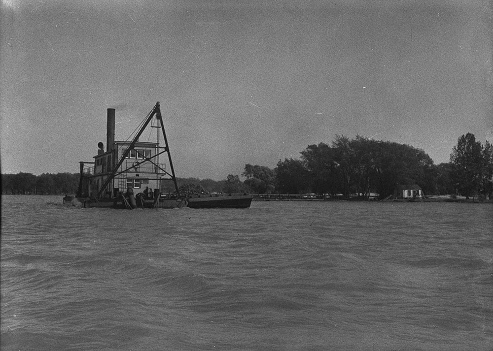
1912 The THC began work in February. Toronto Harbour Commission grand plan created Sunnyside Beach, the Government Breakwater from the Humber to the Western Gap, Lakeshore Blvd., the Eastern Beaches, the Airport at Hanlan’s Point, and extended the entire shoreline across Toronto’s downtown waterfront south more than 1,000 feet. It provided for the terminals and warehouses of a great industrial port. Ashbridge’s Bay was filled in to create an industrial complex. They built a new ship channels and 1000 square foot turning basin. They diverted the Don River into the Keating Channel. They dredged the harbour to 24 feet, but land reclamation also was a major goal. Reclaimed land included 1960 acres, consisting of: Sunnyside and CNE, 220; the Harbour from Bathurst to Parliament, 280; The Toronto Islands, 360; the foot of Leslie 160; from the eastern edge of the harbour to Victoria Park, 940 acres. 3 million cubic yards of landfill was dug from the bottom of the bay. Land was reclaimed through dredging. There were two types of dredges. The first type was the clamshell dredge which was basically a bucket that opened up to scoop material off the bottom. The dredge was mounted on a barge and a had a derrick. When the bucket was full, the derrick swung to the side and dumped the load of bottom material or “spoil” into a scow. The hydraulic dredge was much faster and efficient, able to more material. This dredge consisted of a rotating cutting head, sort of like a man’s electric razor. The cutting head was lowered to the bottom where it churned up vast clouds of loose material that was then sucked up through tubes powered by powerful pumps. A floating pipeline ran from the rear of the barge to the shore, moving huge amounts of soil quickly from bottom to create new land. Toronto’s hydraulic dredge, “The Cyclone”, did most of the work of dredging the harbour and creating new land. It was incredibly noisy, but effective. It could move 20,000 cubic yards of lake bottom in 24 hours.
1912 the Don Rowing Club moved to Leslieville, building a club house at the south end of Morley Road. Rowing clubs used rowing skiffs (a one-person boat) and clinchers (a clinker-built boat) built by William Laing and other local boat builders. (Laing’s boathouse was on Laing Street south of Eastern Avenue.) Other boats were designed specifically for hunting.
1912 Oct 19 SEWAGE NOW CHOKES CHANNEL IT COSTS THOUSANDS TO BUILD
Keating’s Cut Has Not Been Dredged Since Harbor Commissioners Took Charge and Waterfront Is Befouled With Sewage – Boating Made Almost Impossible, and Serious Damage Done to Property
BOAT WENT ASHORE ON DEPOSIT FROM SEWER
Some years ago at a cost of thousands of dollars Keating’s Cut was dredged out to purity Ashbridge’s Bay and allow of a circulation of fresh water. With similar purposes a connection was cut out to the lake down towards the eastern end of the sandbar. it was evidently expected that the harbor would grown down that way, because a channel was dredged out to a depth of seven feet from Toronto Bay right through to Coatsworth’s Cut. And as a matter of fact there has been some development of that kind, especially since the vogue of the motorboat. A swing bridge at Cherry street with a man in charge is still there on the job to allow of the passage of vessels whose masts or smoke stacks preclude their passing underneath a fixed bridge. The swing bridge and the man are there all right, but navigation for all craft drawing more than about four inches of water requires a pilot. This condition has developed during the year since the Harbor commission took over the administration of the Bay and all the works and affairs of the harbor.
Yesterday The Star was invited to take a motor trip of inspection in those waters served by the channel long known as Keating’s Cut. The boat used for the occasion was a speedy craft built at one of the establishments which have grown up down there and drawing about fourteen inches of water. At the mouth of the Don, about one-third out in the channel, at half-speed, the boat suddenly ran up on a shoal and came to a dead stop. All around the boat dense clouds of black water were rising to the surface, accompanied by bubbles and an intolerable stench. A paddle showed showed [sic] the water to have depth of perhaps six inches with a foot of soft ooze below. How far down it was possible to thrust a pointed pole was not determined, but from the nature of the casual soundings taken it would seem that a man might sink in the barely-covered quagmire far over his head. This filth was deposited by the Don River, which at its mouth is nothing more than a huge sewer.
Shoals of Sewage
“I ran the boat up on this much bank just to surprise you,” said the motorboat an. “if we had been going at full speed we would never have got off here without help.”
By rocking the boat and aiding the engine with a paddle the launch was backed off. The resulting disturbance to the silt on the shallow bottom is better left undescribed.
Running further down the cut to where it opens out to a considerable expansion, the launch came to the foot of Carlaw avenue. Here a is open sewer pours out into the channel. Last January the city began work on this sewer outlet; the idea being to make a storm overflow at this point instead of the merely local drain issue that it had formerly been. Instead of rain water, however, the full contamination of the Queen street sewer was turned into it and the foot of Carlaw avenue, where are situated a number of boat-building factories, machine shops for gasoline engines, and other industries, with slips, docks, ways and wharves, has become a hideous cesspool.
Dangerous Cesspools.
The boat-houses where the launches are floated under cover, the moorings where they ride in the cove beside the channel, the shore of the ship yard where men have to work, the foot of the street where children play, present amass of filth floating on water the color of mud, or sliming everything the water touches. Nothing afloat or awash can be kept clean. When the weather becomes warm or sultry the stench is so frightful the men at work in the machine shop close by endure the heat rather than leave the windows open. Fortunately this summer has been a cool one, or a serious effect on the health of the neighborhood would probably have developed. The work of extending the Carlaw avenue sewer has dragged on all summer, and is still far from complete. In the meantime the sewer is open at the foot of the street for some little distance to where it empties at the shore. When the extension is complete the mouth of the pipe will only reach to the middle of the channel, and unless something further is done the filthy condition of the landings at the shore and the mooring places will not be relieved. As it is now, a mud bank composed of the sediment and corruption of the sewer has formed along the shore in front of the property down there. When this sewage is emitted into the middle of the channel, some 50 feet further out, a shoal will form there making the navigation of the cut practically impossible.
Continuing the voyage of inspection to where Keating’s Cut opens out into Ashbridge’s Bay proper, the motor boat again ran up on a muck shoal at the foot of Leslie street. Another sewer pours its burden of filth into the channel at this point, and the water has a depth of only a few inches. Imprisoned sewer gas rose to the surface in a myriad of bubbles. An old wharf stands on the shore at this point out of reach of anything drawing more water than a canoe.
Commission Does Nothing.
Until the new Harbor Commission took Ashbridge’s Bay into their jurisdiction about a year ago, the city has always sent the dredges down Keating’s cut twice a year, according to those who copmalin about the condition that has followed there since that time. The channel was kept at a uniform depth of seven feet, providing sufficient current to carry away the chief part of the objectionable floating matter brought down by the sewers. Boats could be left at their moorings without becoming repulsively filthy. As it is now their owners complain that they might be hauled out and repainted every two weeks and still be in an undesirable condition. Across the slips of the Schofield-Holden Machine Company, a boom has been stretched in an effort to keep out the worst of the floating sewage from the landing places, the launch houses and the ways. but the effort has not been gloriously successful.
“I would sell this place if I could and get out of here,” said Mr. Schofield to The Star yesterday. “Hamilton has offered some inducements to go there. Their bay is quite clean in comparison. Our business is not local. We could do as well at Cobourg or any of those places along the lake. But it seems a funny way to treat us after we have grown up here. I think we are entitled to this channel as a right of way after all these years. All we want is to have the cut maintained as it was when we started here. The G.T.R. started to build a spur down along the north shore of the cut, shutting us all off from the water. They did shut off a lot of the smaller places, but we got out an injunction and stopped them before they got down as far as our property.”
Property is Damaged.
Mr. Schofield is by no means alone in his complaint. Rickey Brothers, boat builders; the Southam firm, and the Graham people are among those who are hurt.
The bridge at Cherry street, where the city keeps a man to open up for boats entering the cut, is practically a fixture these days. It was opened on Sunday five times, according to the bridge-keeper, the vessels being sailing skiffs of light draught, the masts which were too tall to clear the low birders.
“Sunday was a busy day,” declared the bridge man.
The Harbor Commission in reply to a written request that they dredge the channel, refused except on the condition that the firms occupying premises along the shore, surrender control of their water rights at any time after a month’s notice, which they are naturally loath to do. And so the matter remains at a deadlock. In the meantime Keating’s Channel is filling up with sewage, and a dangerous nuisance has been created for the residences on those streets contiguous to Ashbridge’s Bay.
The Harbor Board’s Story.
When the report of these conditions was called to the attention of Alexander Lewis, secretary of the Board of Harbor Commissioners, to-day he said that he had no doubt that they were as described.
“If there was any intention of continuing Keating’s Cut it would be necessary to consider plans for dredging it immediately,” he said. “But there is no intention of continuing. By next spring Keating’s cut will be closed.
“In the general scheme of harbor and water-front improvement which is being worked out Keating’s Cut has no part. An entirely new channel will be made, which shall be a real ship channel. This, of course, is something for which Keating’s cut was never intended. It was built, you will remember, on orders from the Provincial Board of Health simply to provide an outlet for sewage and to help in the purification of Ashbridge’s Bay. It was not, and never has been, a ship channel, and we have decided that the best thing to do is to close it up altogether, as it is not needed in the extensive plans for general improvement that are being perfected.” [229]
1912 Nov 11 CITY TO GIVE RELIEF TO PEOPLE ONSHORE OF ASHBRIDGE’S BAY
The Dumping of Sewage Will Soon Cease—In Meantime Dredge Will Work.
Litigants Winning.
“My clients are desperate. Their water lot has become a cesspool. People will not come to them. Their business is being ruined.
So declared W. E. Raney, K.C., before Mr. Justice Sutherland at noon to-day when, acting for Rickey Brothers, motor-boat builders, etc., he urged that the city be obliged to give immediate relief.
Mr. Raney said that both Carlaw and Morse avenue sewers, until this year, had carried the sewage 200 feet out. But now the sewage was at the shore line.
G.R. Geary, K.C., Corporation Counsel, said the city was sorry on account of the sewage, but the storm sewer would be finished in a few days, and the sewage would be disposed of. As to navigation rights, the Merritt case was fatal to Rickey Brothers.
“Send a dredge down, and clean out the water lot and channel, urged Mr. Raney to Mr. Geary.
Mr. Geary denied that the city had done dredging previously, unless paid for by the Rickeys, but Mr. Raney made this comment: “We paid for dredging our water lot, nothing more.”
What the Harbor Board and city might do was the next phase. Mr. Raney had little faith in their joint action unless the court made an order.
Eventually, Mr. Geary promised to do his best, and the judge said the case might be mentioned again on Tuesday.
“I do not know whether I can get a dredge to-day,” was Mr. Geary’s doubt.
The cost of dredging will go to the trial, which may expected.
Replying to the query, “Will $125,000 be sufficient to pay for the whole work?” Commissioner of Works Harris says: “In my opinion a larger sum will be required to complete the work.”
He states further:
The boulevard will be maintained at the city’s expense.
That a survey is now being made, which will take some weeks to complete, in order to secure an approximate estimate of the costs of the boulevard and bridges.[230]
1913 Feb 18 About thirteen miles of trunk sewer went into operation and the Morley Avenue sewage plant handled all the sewage for Toronto. The system consisted of two east-west tubes, called the high level and low level interceptors which crossed the city and emptied into the Morley Avenue plant. The sewage plant treated it by straining it and allowing most of the solid matter to settle in sedimentation tanks. The liquid left-over went into the lake after being chlorinated. The high level trunk sewer, which ran just south of Gerrard in the East End, was constructed, beginning in 1909. The high level sewer was nine miles long, the low level, which ran near to Queen Street, was four and a half miles long. The plant had a capacity of only 40,000,000 to 45,000,000 a day – the amount of sewage the City produced the day it opened – built-in obsolescence.[231]
1913 July 11 When the wind blew from the east, the currents in the lake carried sewage from the Morley Avenue plant’s outflow pipe into the intake pipe for the City’s water supply.[232] The water in what was left of Ashbridge’s Bay was thick with sewage from the ineffectual treatment plant. The water was now so shallow that there were places where the once deep Ashbridge’s Bay was mere inches deep.[233]
1913 July 11 SOLVING EAST END SEWAGE PROBLEMS
“We are experimenting upon ways and means for betterment of the sewage disposal works at Ashbridge’s bay,” said Commissioner Harris. “In a few days we will have the trickler system operating upon the effluent, and we expect the result will be the purification of the water from the plant sufficiently to have no injurious effect upon the city’s water supply when an east wind makes a current along the shore in the direction of the intake pipes.
“We are now arranging for experimentation with the sludge nuisance, and will keep at it until the nuisance is abated. All this takes time and patience, but we have solved other problems just as great by experimentation, and we expect to solve the sludge problem, and without too great expense.”[234]
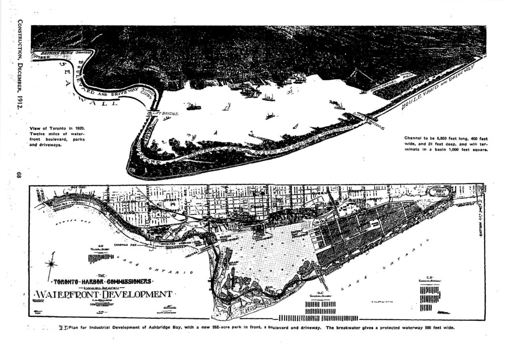
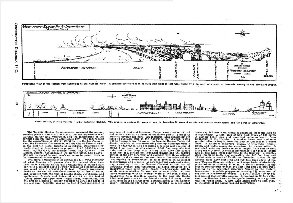
1913 Sep THC approved final plans in September, 1913. [235] They filled in Ashbridge’s Bay to create an industrial area known as the Eastern Harbor Terminals (known now as “The Portlands”). The Eastern Harbor Terminals was devoted to heavy and light manufacturing, containing 644 acres of factory sites, 233 acres of streets and railroad reservations and 130 acres of waterways. The Harbor Commission built a ship channel, turning basin and circulating channel, as well as retaining walls, many engineered and built by John E. Russell, of Leslieville’s Russell brickmaking family. They also constructed a new harbour head line across the entire front of the inner harbour, 1,200 feet south of the shore line, using landfill. They deepened the harbour to 24 feet. They reclaimed 900 acres of park lands east and west along the lake front and on Toronto Island. [236] In the process they killed Ashbridge’s Bay. To fill the marsh a hydraulic dredge excavated sand from the bottom of the lake and from the harbour. The Don River mouth, once divided into two channels called the Little Don and the Don, now was engineered to take a sharp right turn and enter the lake through the Keating Channel. Without its delta to filter the water, tons of silt and pollution now went directly into the harbour where it is dredged.
1913 the Don Rowing clubhouse burned down. They rebuilt, but when the City built the Morley Avenue Sewage Treatment Plant near their clubhouse, the situation became untenable. Raw sewage from the ineffective plant spilled, turning what was left of Ashbridge’s Bay into a reeking sewage lagoon.
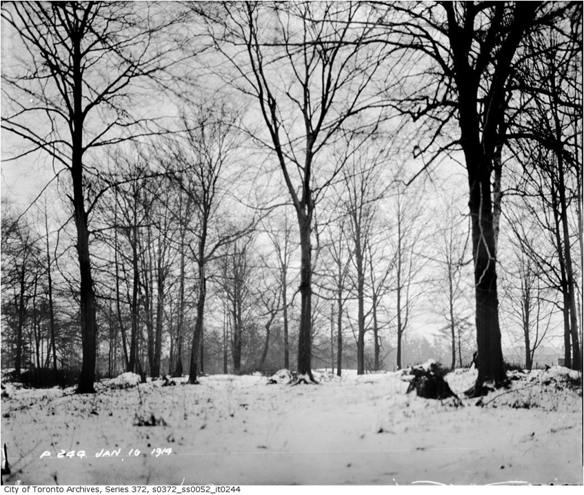
1913 What forest remained consisted mostly of “beech and hemlock, nortably in Ashbridge’s woods in the eastern part of the city.” Ashbridge’s woods or bush was valued by naturalists as a remnant of Carolinian forest, until in was cut down that year to make way for housing.[237]
1914 During World War One the Toronto Harbor Commissioners put themselves at the disposal of the Munitions Board.
1914 One man from Leslieville sadly remembered when there were no sewers to the bay and the water was unpolluted and used for drinking.[238]

1914 Feb 16 Trial Court.
Before the Chancellor.
Rickey v. Toronto: and Schofield-Holden V. Toronto – W.E. Baney, K.C., and H.E. Irwin, K.S. for plantiffs. G.R. Geary, G.C., and C.M. Colquhuon for the city; A.C. McMaster for the Harbor Commissioners. These two actions, begun at same time and tried together, are brought mainly to vindicate claim to “riparian rights” on Ashbridge’s bay as an arm of Lake Ontario, and part of the harbor of Toronto.
Judgment: The broad distinction between the Merritt case previously tried and these is that Merritt’s property abutted on almost dry marsh land, while plaintiff’s lots have water, in front. “Riparian,” the word used in the pleadings, is not accurate, as it applies to a river and flowing water. There is no apt epithet expressive of this unique situation, and so far the sake of convenience “riparian”, may be used. The local situation (as shown by the surveys and plans) when these lands were first granted by the Crown for actual settlement forbids any inference or deduction that riparian rights attached or were to be implied in favor of the patentees. The boundary of their land was an irregular lie forming the northern limit of “the great marsh,” as it came to be called. Land touched land, albeit of a swampy sort, and no place is left for abutment on a water front. When these actions were brought against the city alone, in October, 1912, the right-and-title to the marsh and Ashbridge’s Bay area was vested in the Harbor Commissioners, who were afterwards added as defendants. Both plaintiffs purchased after Keating’s cut had been made, and neither of them had the title to the lots investigated.
Concerning the “water lots,” so called, in front of the plaintiff’s land lots, that became open water by means of an act of trespass on the part of McKee, after he took possession. Another cutting was made by Blong near the place and called Blong street in like manner to the southward, and the severance of the mass of vegetation on each side caused by these preliminary cuttings, so disconnected the intermediate floating marsh that it was torn off by the combined action of the elements and carried away, leaving a gap in the marsh at that point, which is first marked in Jenning’s plan of the harbor in 1890.
This place has been kept open since by dredging, and the situation has been so changed that it is impossible now to ascertain with any accuracy the real condition before these acts of illegal displacement. The only pretence I can see to claim navigable water or access as of right is the water in front of these lots, originate with these acts of spoliation and trespass, and the origin indicates the illegality.
By dredging and by the construction of Keating’s cut the place has assumed a riparian and navigable aspect, but the uses of the water has been permissive, and not as of right, and the really navigable part has been created by art and science.
After coming to the end of a necessarily devious course in the consideration of this contest I have reached, for the various reasons given, the conclusion that the plaintiffs have no claim to riparian rights, and have no right of access by water to what may be the navigable water or made be made the navigable water in Ashbridge’s Bay. This dispossess of the main causes of action as to water rights. The plaintiffs also complained of other matters: First, that the nuisance created by the discharge of sewage, especially by the additional output in the year 1913, should be restrained and abated; and nest, as to the plaintiff, Schofield, that damages should be given for the injury done through opening Carlaw avenue and so interfering with his business and with access to his premises.
As to the nuisance from the pollution of the water and the air by reason of the discharge of foecal and other mal-odorous substances into Ashbridge’s Bay, no case is made out for interference on behalf of an individual. In these respects of water and have been proper matters of investigation by the court at the instance of the Attorney-General or upon criminal prosecution.
This damage to the business of the plaintiff on the water side is not recoverable from the city. The plaintiffs had no right to go to and fro with boats over this part of the marsh, which belonged to the city. No obligation rested on the defendant quoad the plaintiffs to keep the water free from refuse or from being blocked.
The whole of Rickey’s front, as occupied, is an encroachment over the Unwin line, and so is Schofield’s to a great extent – all but the slip. There is some evidence to show that the city failed to exercise reasonable expedition in completing the restoration of Carlaw avenue to a travelable condition alongside Schofield’s place. he appears to have sustained loss of business, probably for some months, on this account, for which he may recover in this action. For other injuries, if any, arising from the method of construction, compensation must e sought by process of arbitration and not by action.
It will be referred to the Master to assess damages for injury suffered by the plaintiff Schofield for want of proper access by land to his business premises by reason of delay in completing the restoration of Carlaw avenue after it had been opened alongside his premises for the purpose of putting the concrete sewer in the year 1912, and prior to October 30, 1912. Costs of this part of the case and costs of reference will be reserved till further directions.
As to the Harbor Commissioners, both actions are dismissed with costs.
Schofield’s action against the city, so far as water rights are concerned, is dismissed with costs; so far as nuisance and sewage is concerned it is dismissed without costs; so far as damage to business is concerned, costs reserved till after reference.
As to the city, Rickey’s action concerning water rights is dismissed with costs; for the nuisance and sewage, dismissed without costs. (Note—The Judge notes that the earlier maps and plans referred to have been collected by the indefatigable zeal of John Ross Robertson, Esq., in his valuable publications on the” Landmarks of Toronto.”)[239]
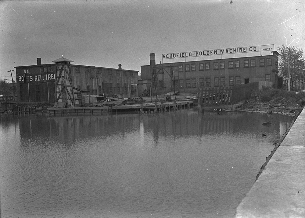
1914 Feb 17 MOTOR-BOAT BUILDERS MAKE PUBLIC PROTEST
Object to Their Treatment by the Harbor Board Regarding Rights on Ashbridge’s Bay.
INCREASE OF SEWAGE.
Declare Will Be Forced Out of Business When Deprived of Access to Bay.
Builders of motor boats who are located on Ashbridge’s bay are protesting strongly against the treatment given them by the Harbor Commission, and have written to The Star the following letter, in which they state their case. It is signed by the Schofield-Holden Coy., Rickey Bros., Canadian Machinery Repair Coy., and Southam Bros., Gasoline Engine Works:
“In November 1911, the city made over the Ashbridge’s Bay area, that is to say the marsh and the bed of the bay, to the harbor Commissioners in trust for the city.
“In the Spring of 1912 the Harbor Board announced its intention of closing Keating’s Channel and filling Ashbridge’s Bay, and notified us that it would decline to acknowledge that we had any rights through Keating’s Channel to Toronto Bay. That attitude, if it could be supported, spelled ruin to us, because communication with Toronto bay by water was vital to our business. About the same time the city increased the area drained by the Carlaw avenue sewer from about twenty acres to upwards of seven hundred and fifty acres, and deposited this enormous quantity of sewage just at this shore line, until the condition became such that it as described by the Provincial Inspector of Health as ‘abominable’ and the worst he had ever seen.
We appealed from the harbor Board to the then mayor and Board of Control, and back to the harbor Board, each referring us to the other without success, except o discover that both appeared indifferent to our destruction. We then appealed to the court, and we now have the announcement that, for reasons too lengthy to reproduce here, but depending partially upon the condition of things where we are now located when the original grants of the township lots were made by the Crown 120 years ago, and partially upon the legal doctrine that here is no private remedy for a public nuisance, we are told by the court that we have no legal recourse.
Discuss Honesty and Decency.
“We are not desiring to discuss these points of law. They are too deep for us and we will be content to leave them to the lawyers and to the courts. What we do desire to discuss is just common honesty and common decency, things that we may be supposed to know something about without being lawyers.
“The business of boat building for which Ashbridge’s Bay is peculiarly well adapted has been an industry there for a generation before the construction of Keating’s channel in 1894 the boat builders had communication with Toronto bay by natural channels. Since Keating’s Channel was put through it has been the water highway between the two bays, and as such has been in constant use by us. Some of us are successors in business to men who started before Keating’s channel as dredges; others of us have acquired our properties and built our buildings since then. Deprived of access to Toronto Bay, we shall e compelled to give up our businesses and our properties will be worthless for our purposes.
Established On Faith.
“We established our present businesses on the faith of things as they were—that is to say open navigable waters in Ashbridge’s by a right up to our shore line and a navigable connection with Toronto Bay. There never was a suggestion that Keating’s channel was not navigable.
Notices Were Posted.
“But last summer the Harbor Commissioners posted conspicuous notices along the channel warning the public that the cut was ‘for sanitary purposes only’ and, that ‘persons using it for navigation do so at their own risk.”
Cannot Understand Reasons.
“Assuming for the moment, that the Harbor Board is within the law in what it has done, does that make it honest or decent? If the Harbor Board had aproached [sic] us and we had put forward demand which they thought were unwarranted there might perhaps be some justification. But the harbor Board had never approached any of us in any manner whatever except to intimate that no attention is to be paid to us. The members of the board are gentlemen of reputation and we are sure that neither Mr. Lionel H. Clarke nor Mr. F.S. Spence nor Mr. Home Smith nor Controller Church would, for his personal advantage, do what they as a board are doing in this case. And we are also quite sure the citizens of Toronto whose servants the members of the Harbor Board are, do not desire them to destroy us in order that the city may be saved what it would cost to compensate us for our loss.[240]
1914 The first starlings in Ontario appeared at Niagara Falls in 1914. [241]
1914 The passenger pigeon was extinct.
1915 Feb. 15 BOUNDARY WATERS TO BE CLEANED UP
Every town and City Along Great Lakes Must Purify Sewage Before Dumping.
Toronto Takes Lead
Pace for Sewage Treatment Set Here Before Orders Are Given.
Towns on both sides of the Great Lakes will soon have to prevent pollution according to members of the Joint Commission. “a general clean-up must take place and that the towns and cities on the shores should bear the burden of the purification process.” Multi-million dollar expense. “In essence, this means that all the points on the shoer line from the St. Lawrence River to the head of the great lakes will be required to treat their sewage, and that not one quart of raw effluent will be dumped into the current.”
“One gratifying feature of the investigation has been the discovery that Toronto alone has taken steps of this kind on her own initiative, and has set and example to places on both sides of the line. This city has gone even further in sewage purification than the commission’s regulations will call for.”[242]
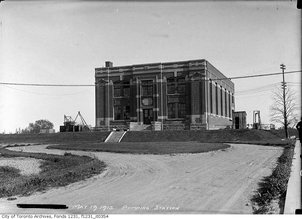
1915 March 13 “Toronto at the present time is defending a suit for damages through destruction of fisheries by filling up of the bay by sewage.
Before the sewage was allowed to be deposited in Ashbridge’s Bay, the claimants declare that the water was almost drinkable, and all kinds of edible fish could be caught near the shore. Now there is a green turbidity, caused by the presence of a large amount of decomposed and decomposing organic matter, which under certain conditions of temperature forms a thick yellowish-green scum on the surface of the water, which, when blown ashore, gives off an offensive, nauseating odor. These conditions, it is alleged are due to the action of the city in discharging sewage.”[243]
1915 June 2 by 1915 the City claimed that it was too expensive to stop the stench, estimating it would cost $2,500,000. The Morley Avenue residents tried to have the city arrested for creating a nuisance.
The Morley avenue septic tank, probably the most talked-of civic nuisance in Ward One, is again in the limelight. This time the Police Department, at the instance of a number of ratepayers yesterday indicted the city on a charge of maintaining a nuisance. The summons has been served on Solicitor Johnston, who will appear in the Police Court to defend the case.
Mayor Thomas (Tommy) Church called in Assistant Solicitor Colquhoun, Dr. Dharles Hastings, the Medical Officer of Health, and Deputy City Engineer Powell before the Board of Control to ask they were going to do to stop the smell. Dr. Hastings and Commissioner of Works R.C. Harris, had been testing different methods and concluded that it cost to much to stop the smell entirely. Church said that always been opposed to building the plant, and “if he had his way he would relegate it to the scrap heap.” However, this populist mayor had no alternatives.[244]
1915 June 2 The Morley avenue septic tank, probably the most talked-of civic nuisance in Ward One, is again in the limelight. This time the Police Department, at the instance of a number of ratepayers yesterday indicted the city on a charge of maintaining a nuisance. The summons has been served on Solicitor Johnston, who will appear in the Police Court to defend the case.[245]
1915 Aug 7 Report of Experts on Morley Avenue Sewage Disposal Plant. To get rid of the offensive odors would supposedly cost six million dollars, according to the report of Commissioner Harris and Dr. Charles Hastings. “all experiments for the improvement of the present system were without result”…They recommended that Imhoff tanks be installed but that would cost $6 million. They also recommended opening a channel to Ashbridge’s Bay presumably to let the sewage drain into the lake.[246]
1917 All Necessary Harbor Work Will Go Ahead
Hon. F. B. Carbell Relieves Toronto’s Fears – No Undue Cuts to Be Made
New Minister Sees Waterfront Here
“Both parties are More Willing to Make Sacrifices in Maritimes Than in Ontario”
“No harbor improvements in Toronto will be discontinued which are necessary for the prosecution of the war,” declared Hon. F. B. Carvell, Minister of Public Works, speaking to The Star to-day.
When seen by the Star, the new Minister of the Union government was enjoying a smoke in the rotunda of the Harbor restaurant at Sunnyside. Mr. Carvell’s active nature was evidence by the fact that while many of them were sitting down, he was walking up and won in front of the fireplace.
Traversed Waterfront.
During the morning, Mr. Carvell, had covered the whole waterfront from Ashbridge’s Bay to the Humber. He was particularly interested in the work of the British Forgings Plant at Ashbridge’s Bay. he was accompanied by E. I. Cousins, chief engineer of the Toronto Harbor Commission: Roger Miller, chairman of the Supervisory Board of Engineers; Fred hand, the Government resident engineer; Fred Miller, of the Imperial Munitions Board; L.H. Clarke, chairman of the Toronto Harbor Commission, and John Sweeney, manger of the Canadian Stewart Company.
“Is it true that you have said that you will stop the Toronto harbor improvement work?” asked The Star.
“Give Me a Chance.” “You had better give me a chance,” replied Mr. Carvell. “If I say I will, I likely will, but I haven’t said so yet. The Government will be reasonable in everything it does, but it must be considered that there is a need for retrenchment all over Canada. You may tell the people of Toronto, however, that no work will be stopped which is necessary for the prosecution of the war.”
Big Cut in East.
“It has been said that you are spending money on harbor improvements at St. John and Halifax and slighting Toronto,” stated The Star. “I have cut off an appropriation of one million dollars that was passed at the last session for the St. John harbor, and don’t think that shows that I have favored the East. The work at Halifax is under the supervision of the Railway Department.”
“Do you feel at home in your new position?” asked the Star. “I have lots of work to do,” replied the Minister. “If that means that I am at home I suppose I am.”
…During his tour of the harbor work Mr. Carvell was joined by Mayor Church.
Of the 171 acres that have been reclaimed by the harbor improvement work 150 are being used for war purposes, and consequently it is not believed that Mr. Carvell will use the axe on the Toronto improvements.[247]
1917 The Munitions Board built a $3 million plant on the Eastern Harbor Terminals. It occupied 60 acres. The Harbour Commission was in charge of the work, building electrical and forging facilities. Dockings and rail lines were built near Cherry Street to accommodate the plant.[248]
1918 According to John McPherson Ross:
Ashbridge Bay…was a beautiful sheet of water when I first saw it in the summer of 1863, and was clean and good enough to drink, abounding in fish, and was the haunt of numerous wild fowl all summer. In the stormy, rainy fall, it was alive with wild ducks of all kinds that came to rest on their southern flight and to feed on plentiful masses of wild rice that grew in numerous patches. The marsh covered the shallow waters of the eastern part of the bay at the commencement of the sand bar by the foot of Woodbine avenue, as this roadway is now called. When the racetrack of that name was first built the marsh growth ended where the deep water started, and began again intermittently a little west of Leslie street. It was quite a fine sheet of water, and at the time of speaking the lake had made a cut at about the size of the present entrance.” [249]
Peculiarly weird and picturesque would be scenes in the marsh before the spring growth had started, when parties would go spearing pike. Generally always two, one had to paddle, while the spearer would stand in the bow. An iron contrivance called a “jack,” filled with several pine knots in full blaze, was fastened in front of the boat, and threw a lurid flame on the dark waters below, revealing a gliding pike, attracted by the light and coming to his speedy death, for the skillful spearer impaled in on his barbed spear. On dark nights in early spring it was a common sight to see a dozen or more parties, with the jacklights flitting slowly over the marsh, like so many will-o-wisps luring the fish to their doom. Later in the century, although it was no longer possible to spear salmon, fishers used fishing pole, hook and line to catch pike, bass and muskellunge off the wharves. In the winter they fished through the ice: As the ice got thicker the little houses of the fishermen would appear scattered over the bays, in spots selected, where the currents brought the wily pike. Here inside in the dark would sit a hardy fisherman, smoking his tobacco, black and strong, now mostly used for chewing as the lighter of yellow kind was not then in ordinary use. The water would be full of greenish light, and the fisher, either with hook or spear, watched this spot with catlike faithfulness, his patience being fully rewarded when he would land a seven or eight pound pike. [250]
The Ashbridge Bay and the marsh in those days was a very important feature as it furnished the residents of the neighborhood a place for recreation for old and young of both sexes. There were always plenty of boats owned in the vicinity, and for hire. In the long summer evenings boating parties were the favorite amusements till late at night. Music and singing filled the air and echoed along the shores. The plaintive strains of “Nelly Gray,” or “Willie Has Gone to the War,” to the accompaniment of accordeon or concertina, were usually the favorite songs, sometimes varied with “The Charming Young Widow I Met on the Train,” or “Molly Brown,” the last a pleasing melody of the time much favored by the sentimental lads and lassies of the day. Especially on the moonlight nights, the placid waters of the bay would be well patronized, and the air made melodious by the songs just mentioned, while in the darker reaches of the marsh you could hear the drooping notes of the coot and the harsh cries of the mudhen. [251]
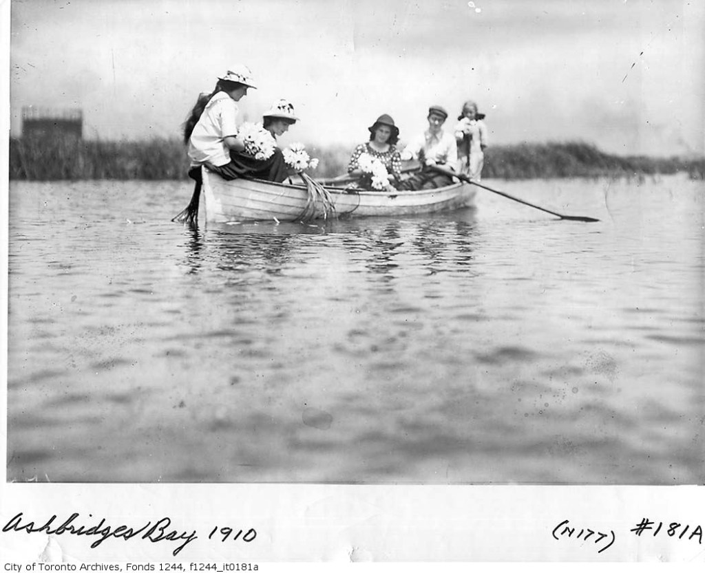
But when the marsh was frozen hard, busy scenes were enacted. Men could be seen cutting and gathering the marsh hay, to be used for bedding horses or for stuffing mattresses. Great quantities were frequently used for core making in the foundries of that time. [252]
He described the decline of the Bay: The first element to spoil the purity of the bay waters was the liquid excreta of the cattle byres which were built by the marsh-side a little east of the Don to use surplus hot swill, a by-product from the distilleries after the spirits were distilled. This waste liquid manure was run off into the bay and so sullied its waters as to lead to damage suits, which were entered against the company by boatmen whose business were affected, claiming they could not hire out their boats as the fishing was spoiled. Other parties also claimed damages on property grounds, claiming that they byres prevented sales of land, the renting of houses, from the very nature of the business and the general unsightliness of the plant or buildings. The claims were settled for certain monetary considerations accepted by the plaintiffs and the planting of several rows of quick growing trees to hide the unsightly buildings. The nuisance still remained and was a great detriment to the fair name of the east end from that day to this, besides hiding the pollution of a considerable area of the bay or marsh.[253]
The opening of Eastern avenue and the building of the houses, coupled with the necessary sewage from the different streets, fouled all the water, which soon came to be little better than an open cesspool. This created such an outcry from the public that he Keating Cut was made along the face of the windmill line to make a current from the lake to the City bay, which somewhat improved the sanitary conditions for a while. The city began to fill portions of the front marsh with garbage and excavations which made solid land, but previous to this the Government made some improvements as a piling from the Don outflow over to the Island, which formed a roadway that enabled summer residents on Fisherman’s Island to go back and forth to their homes. The boundaries of the marsh proper began to shrink and many schemes were advocated to improve and use the Bay…The establishment of the septic tanks was the last straw, the crowning disgrace to be placed there. The poor old bay … became a place to be shunned, and what was a place of pleasure on holidays for many to enjoy a day of fishing or rowing, or sailing, or in the winter season for skating or ice-boating, became a place to be avoided winter and summer. [254]
J. McPherson Ross described the “joy of skating”: The main part of the bay, when the ice was clear, and before it was thick enough for the ice harvest, would be covered with hundreds of people skating, and the merry shouts of the boys as they skated and played “shinny” made a lively and tumultuous sight, while ever and anon would come a booming sound as the pent-up currents of water underneath surged heavily against the imprisoned top. Oh, the joy of those days that the writer recalls—to be young and strong, with a sharp pair of skates fastened to your top-boots and the long straps securely crossed and buckled tight, and a clear mile of smooth ice before you to go bounding over; a strong shinny and a puck of hard maple to knock, dodging and twisting over the glassy surfaces. The joys of the present youth have nothing on those bygone thrills.[255]
The ice of Ashbridge’s Bay was used to hold races. Men laid out a mile track on the bay. Large crowds attended the races and enjoyed refreshments served by vendors whose little wooden shacks dotted the ice. Whiskey and beer, flowed copiously, cheap and strong.[256]
Trappers got plenty of muskrats and it was a common sight to see numerous figures out in the marsh with a bag on their shoulders and a spear-like weapon to dig out the rats from their winter houses or catch them in traps set for the purpose. [257]
The fishermen who lived along Kingston Road (later called Queen Street) owned many large sailboats, probably mostly schooners. Many a large sailboat might be seen those days at any time near the sidewalk on the Kingston road, later called Queen street. 1918 “Quite a colony of fishermen lived near by, among whom we remember the names of Doherty, Laings, Marsh, Goodwin, Crothers and others who, if not fishermen, were duck-hunters or trappers. Or they also enjoyed the boating, fishing, and bathing privileges which were here in all their primeval abundance and purity of nature become becoming soiled and destroyed by the sewage and filth of the encroaching city.”[258]
When the ice got to be six to eight inches, then the icemen appeared and several parties would commence the winter harvest. Great ice-houses in those days lined the bay at convenient spots for floating in the crystal blocks. This continued for several weeks, and was a busy time while it lasted. They generally saved all that the modest city required in those days, and it was not till the mild winter of 1880-81 that efforts were made to secure ice, outside, from Lake Simcoe, for the usual supply. Ice was cut, though, for many years afterwards till it was finally stopped by the city officials as being unfit for use. Up till then crowds of men and teams were kept busy in the operations of the ice harvest by the different companies engaged in that business. [259]
On days when the east winds were throwing up big breakers on the Island quite strong seas came sending over the bay, sufficient sometimes to wash out by the roots large poplars that grew on the street now called Leslie. In those times several creeks added their quota of waters to the bay. The overflow of Small’s Pond and a small creek at about Kenilworth avenue ended in the marsh, another one came through Ashbridge’s farm. One coming through Hastings’ and crossed the Kingston road and emptied into the gut, as it was then known. This gut was quite a sheet of water and formed a little harbor made use of by the fishermen who lived near it, and who ran their boats up the channel to the back of their lots which ended on the water.
Another creek started near the Danforth road and ran near the sandpit down through several market gardens, crossing the Kingston road at the foot of Pape’s lane, by a big willow tree that grew there on the south side, and ended its journey in the marsh that came almost to the road. This marsh was filled with willows, alders and other growths that made quite a thicket, and was the roosting places of many wood-ducks and other denizens of this safe, marshy, woodland retreat, such as the bittern, woodcock, snipe, plover, sandpipers, and crow blackbirds or grackle. In fact, here and elsewhere wild life was teeming, and the naturalists of those days might revel in the enjoyment of their favorite study. The marsh continued south and was unbroken till it ended at the Island, then went westward, with the exception of a patch of clear water of several acres’ extent, known as Brown’s Pond, which skirted the shore edge of such properties as Heward’s, Gorrie’s, Blong’s, Clark’s and ended with Smith’s, which also ended on the Don River. I omitted mentioning a creek that also started near the sandpit and ran through the gardens of Cooper’s, Bests and Hunters, crossed the road by the Leslie Postoffice. Here it joined a small creek that drained the nursery, and both crossed Leslie street under a bridge that has since been filled up by intersecting sewers. [260]
1919 Thomas Thompson of Pape Avenue, drowned off the foot of Morley Avenue (now Woodfield Road). He was seventeen. Six young men were rowing an overloaded dinghy out to a sailboat in Ashbridge’s Bay. A big wave capsized the boat. Five survived, one died. “Although the six of them made a heavy load for the punt they all set out from the foot of Morley avenue for the two hundred yard row and were about half-way then the upset occurred. They sat a huge wave partially swamped the boat and that they were all precipitated into the water when two of the men who were deluged by the water stood up in the boat..[261]
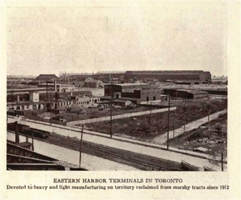
1920 The Eastern Harbor Terminals became an industrial area devoted to heavy and light manufacturing, containing 644 acres of factory sites, 233 acres of streets and railroad reservations and 130 acres of waterways. The ship channel was 6,800 feet long, 400 feet wide and 24 feet deep. It terminated in a turning basin 1,100 feet square. The work created over five miles of dockage, and could accommodate boats of 24 feet draught.[262] Toronto naturalist Charles Sauriol remembered “vivid recollections of the smell of burning garbage that hung over the area during the “fill” operation.[263]
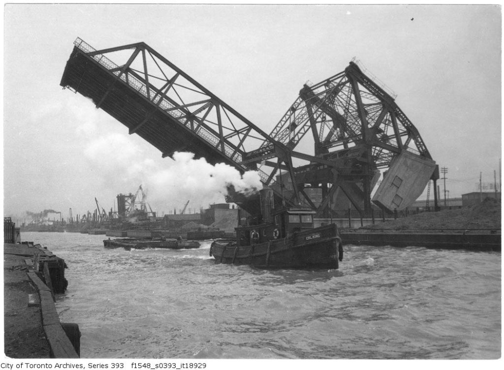
1921 The Ashbridges Bay work of the Harbor Commission had already produced 450 acres of land fully reclaimed and another 400 acres partially reclaimed. They had produced two miles of new streets, two and one-half miles of concrete sidewalks, water mains and sewers and five miles of railway sidings. Twenty-four industries were operating there. New industries quickly moved in. An electrically operated Bascule Bridge built at that time still spans the Keating Channel at Cherry Street and is the main route by car or truck to the Portlands.[264]
1921 the Don Rowing Club asked the THC to provide a new place for their clubhouse. It did not happen.
1923 the THC completed landfill operations. By then, to the consternation of local residents and the rowers, the Dons, the THC’s landfill operations began gobbling up Woodbine Beach.
1923 April 20 BEACH RESIDENTS ORDERED TO MOVE
Health Authorities Consider Small Dwellings Unfit for Habitation
Protest was made at the City Hall yesterday on behalf of residents of Woodbine Beach, a strip of land between Ashbridge’s bay and Lake Ontario, lying south of the Woodbine race-track, who have been ordered by the Medical Health Department to vacate their houses, as they are reported unfit for human habitation , not being served by civic sewer and water systems.
These houses, 40 in number, are nearly all owned by their occupants. They are workingmen’s small homes, and are built on land leased from the Harbor Commission one one-year renewable leases. The Medical health Department some time ago notified the Harbor Commission that the houses would have to be closed up unless the commission installed sewers and water mains there. The commission refused to do this, on the ground that the land would soon be used for purposes other than accommodation of dwellings, and therefore the commission was not justified in spending a large sum of money to put in sewer and water services for a short period of time.
The residents secure their drinking water from wells in the sand, and claim it is pure. The Medical Health Department claims the wells are contaminated, and that conditions are extremely favorable for the outbreak of a bad typhoid epidemic.[265]
1924 Four children drowned in McNamee’s Cut. Some teenagers were ferrying a crowd of about 20 children on a make-shift raft through the cut near the foot of Cherry Street into Ashbridge’s Bay. Young people from Fishermen’s Island had made the raft for their convenience and to allow the young people to go over to sandbar and swim. The raft was about 10 feet by 6 feet. The children overloaded it and when it began to rock, they all rushed to one side, and the flimsy craft tipped over, throwing the children, many very young, into the Bay. Teenagers on the raft, on nearby sailboats and on shore rescued the children. The dead were: ROBERT LONG, 325 Wilton avenue, aged 7 years. GERTIE HARVEY, 22 Sumach street, aged 12 years. ALBERT DIRSCOLL, 99 Trinity street, aged 3 years. WILLIE BYTHELL, 101 Trinity street, aged 9 years. [266]
1925 A 20-FOOT BY 5-FOOT V BOTTOM RUNABOUT, SCRIPPS 2 FOUR MOTOR ABOUT 25 MILES PER HOUR, THE WHOLE OUTFIT ABSOLUTELY NEW PRICE, $1,500. APPLY DAWSON’S BOAT HOUSE, FOOT OF MORLEY AVENUE. GERRARD 5693.[267]
1925 CITY’S SEWAGE PLANT AFFECTS ROWING CLUB.
Billed for $1,200 Rental and Ask to be Relieved
“The city ought to pay us for staying there,” said Hon. Joseph Thompson, speaker of the legislature, in addressing the board of control to-day on behalf of a deputation from the Don Rowing Club, asking relief from the payment of a bill of $1,200 for rental of the land occupied by the club at the foot of Woodfield road. Mr. Thompson said that distressing conditions had set in since the club located there, these being due to the proximity of the sewerage disposal plant. The result was that the membership had decreased. He contended that there was a verbal arrangement under which the club was to pay a nominal rental and it had not received a bill for 12 years until a month ago when one for $1,200 was presented. The board referred the request to the assessment commissioner for a report.[268]
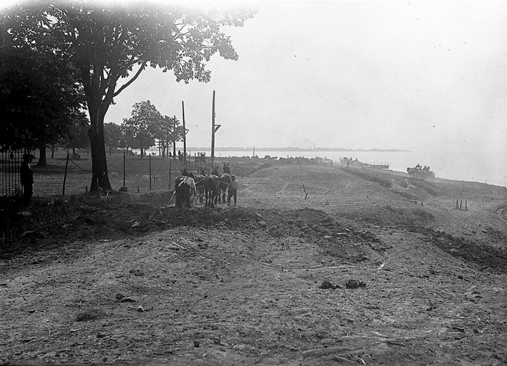
1925 Lakeshore Blvd. was built and was considered by some to spoil the waterfront.[269]
1927 Beach residents were concerned that the Harbor Commission would develop the beach even east of Woodbine Avenue. They wanted the beaches placed in the hands of the Parks Committee for more parkland. The residents would clearly fight any attempt to industrialize the Beach. (Plans to run a major rail corridor through the Beach came to an end.) By that point, Ashbridge’s Bay was thick with sewage. The Dons were so nauseated that they threw up while rowing, their oars digging deep into human excrement. The water was now so shallow that what had been deep holes were only now inches deep.
The Beach was not about to be industrialized as Ashbridge’s Bay had been and residents were there to fight any threat. Residents of the East End were concerned that the Toronto Harbor Commission under General Langtin, would develop the beach east of Woodbine Avenue. Residents wanted the beach placed in the hands of the Parks Committee for development of more parkland. Langtin stated that no further filling east of Leslie Street would be carried on. The City’s permission would be need for that because of the Morley street sewage disposal plant. To develop the beach east of Woodbine Avenue would be require expropriating property. Alderman Baker asked that the Commission forward copies these assurances to the aldermen from the East End. “This is a very serious thing for us,” he said.[270]
1930 Power cruiser, 41 feet, splendid condition, full one-man control, every convenience, owner must sell. Dawson’s Boat House, foot of Woodfield, or phone Adelaide 0902. [272]
1931 The vigorous hunting of the day virtually wiped out many species and did, in fact, exterminate some. The abundant Mallard ducks we see along the Toronto waterfront are descendants of tame birds released in 1931. They may also be the offspring of wild Mallards who expanded their range, out-competing Black Ducks for habitat.[273]
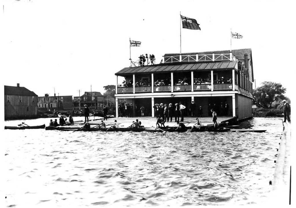
1932 Don Rowing Club’s rebuilt clubhouse again went up in flames. Bob Dibble, local businessman and war hero, applied for land on behalf of the Dons near Coatsworth Cut, but this fell through. The Don Rowing Club disgusted, left for cleaner pastures, never to return.
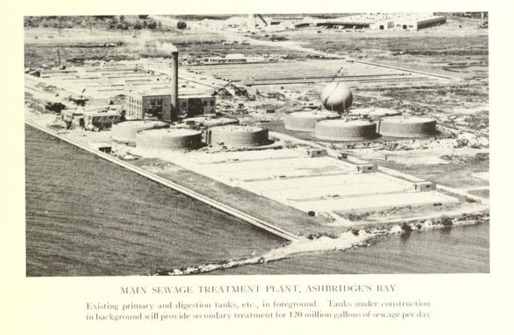
In the Second World War, the provincial Department of Health tried to convince the City of Toronto to build a new and more modern sewage treatment plant on Ashbridges’ Bay. The Province was concerned about the possibility of raw effluent spreading polio, especially to swimmers enjoying the near-by beaches. The old Morley Road plant was basically a drainage pumping station, built in 1912, and septic tanks. It was inadequate and antiquated. The City agreed to build a new seawall and plant — eventually. Even if this was done, they were aware that peak storm water flows would likely still carry raw sewage into the lake. They downplayed the consequences and alleged there was no way to get around the problem.
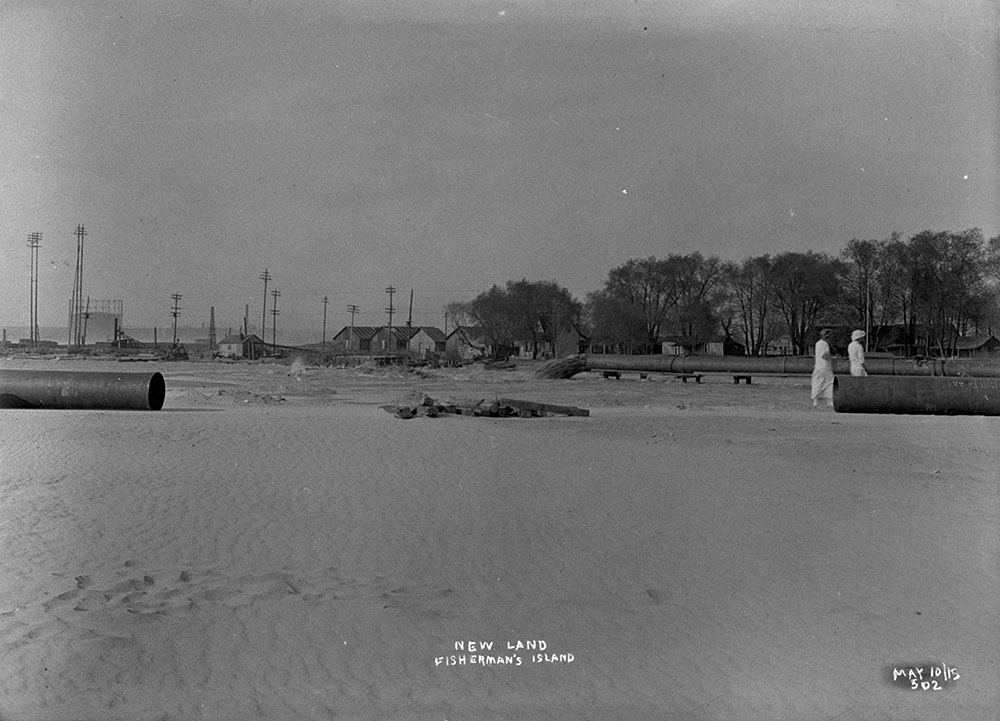
1945 Frank Smith, woodcarver, naturalist:
“I was born on Fisherman’s Island, near the foot of Cherry Street…in the days when there was no limit on the number of ducks a man could shoot. A man by the name of William Loan used to make his living shooting ducks and in trapping in Ashbridge’s marsh. He rowed a 14-foot boat and carried a four-gauge shotgun, and I’ve seen him fill that boat with ducks so that he couldn’t put another one in it.”
“He belongs to the Field Naturalists’ club and the Ornithologists’ club of Toronto, and every second Saturday morning he explains to a class of boys and girls at the Ontario Museum how to carve birds from wood and how to recognize them in the field.
He carried his hobby a step farther when he found that many of the harmless, useful birds of the Toronto district were being shot by careless or ignorant boys. He became a deputy game warden.
…As a field ornithologist, he helps Herbert Southam, official bird bander for Ontario, affix bands to the legs of migratory birds, so that the habits of the birds can be learned.
“Last year we fixed a band to the leg of a sandpiper and we heard, through Washington, where the records are kept, that it was found, 10 days later, in Montevideo, South America. It had flow thousands of miles in the ten days, besides stopping to eat and sleep.“There are,” said Frank, “about 20,000 amateur naturalists in Toronto, and there is no finer hobby, nor one that will give you better health, than watching the birds and learning about them.”[274]
1952 The last of the marsh was filled in to make land for the Main Sewage Treatment Plant. The natural filtration system that kept Toronto’s harbour and adjacent waters even in a semblance of natural health was long gone.
1955 The contractor for the new plant was Rayner Construction Company and the engineers were Gore and Store and Metcalf and Eddy. The Highland Creek plant was opened in 1955. The Humber Bay Plant was opened in 1955 and relieved pollution at Sunnyside. A new sewage treatment plant was being built on the Long Branch rifle range. [275] In 1955 The Main, Highland Creek and Humber Bay sewage treatment plants opened. [276]
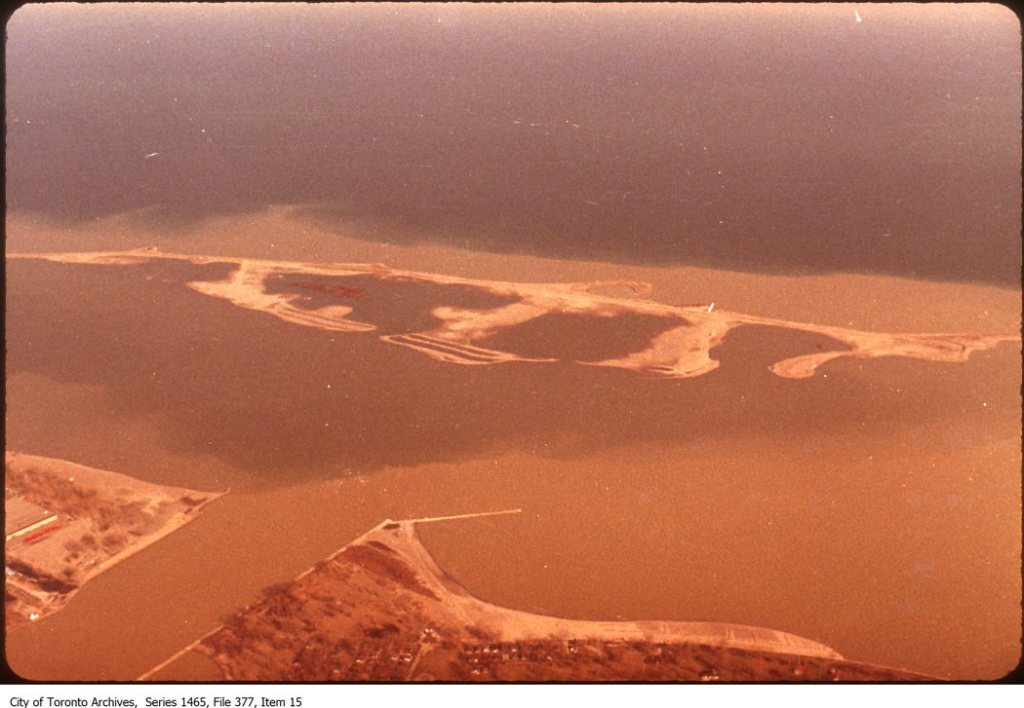
1955 The Leslie Street Spit or “East Headland” was begun as a place to dump fill from the construction of Toronto’s subway.
1956 the Eastern Gap was 18 feet deep.
1958 Many were expecting that the opening of the St. Lawrence Seaway would provided the same shipping boom to Toronto as the opening of the Welland Canal. The demand for a modern port was high.
1958 there was again great public concern about the waterfront, including the Leslieville area. People were concerned about the disappearance of public beaches, the loss of natural beauty and the fouling of picnic areas with waste. Raw sewage was spilling out of the overtaxed sewer system and fouling the beach. In a 1958 Globe and Mail article, attention was focused on the disappearance of public beaches, the loss of nature, the fouling of picnic areas and parks with garbage, vandalism and crime in parks, and pollution. In particular, it was obvious that raw sewage was overtaxing the treatment system and going into the lake and harbour. There were calls for a new Ashbridge’s Bay sewage treatment plant. [277]
1961 Dr. Norman Scollard, Curator of the Riverdale Zoo, released Canada geese on Toronto Island. They multiplied and became decoys for their wild cousins, drawing them in from the sky. The Department of Lands and Forests contracted with the Kortright Waterfowl Park, Guelph, to release geese at various points around Ontario.
1961 the Ashbridge sisters fought to save their trees suffering from Dutch Elm Disease. The 80 foot American Elm was badly damaged with only two boughs left, but the Ashbridges had always loved the elms that towered over their house, shading it from the sun, and sheltering orioles and other songbirds. They paid for a tree surgeon to do his best, but William Price thought that the tree only had three more years at most to live. Two other elms might he thought, live another 50 years.[278]
1964 a boater’s lobby pushed the City to build a new harbor for marinas between Coxwell and Leslie Street using landfill, mostly construction debris.[279]
1965 Frank Smith, a member of the Toronto Ornithological Club, who died in 1965, said:
I have seen thousands of Muskrat houses built in it at one time and am safe to say that as many as ten to twelve thousand rats would be taken in one spring….It was a problem catching Mud Turtles. The best way was undressing and taking a sack, walk in the water up to your armpits and when you stepped on a turtle you would duck under, get him, and put him in the sack [sic]. I have taken as many as seventy-give to a hundred in one day in this way and sold them in the market for turtle soup.[280]
1966 the oldest Ashbridge elm finally came down, leaving only two of the historic trees alive.[281]
1968 there were about 1,000 feral geese in southern Ontario.[282] There are many, many thousands today.
1969 the East Headland or Spit was considered finished. It was not. Meant to be 1.6 miles long, it kept growing and growing – and then grew some more. Everyone had a different idea of what this could become. Developers wanted to make the Leslie Street Spit a major port. Tommy Thompson, Park Commissioner, and others fought to make the Spit a good place for nature and recreation.
1970 Mayor Crombie set up a task force to recover industrial jobs that had fled the city for the suburbs. The Crombie Plan called for bike paths, waterfront vistas, parks and services to revitalize the waterfront. The Plan called for the creation of a 472 acre industrial park on the former Ashbridge’s Marsh. Most of the land was owned by oil companies and some of it was very contaminated, land called “brownfields”.
1970 The Olympic dream has haunted Toronto for sometime. In the early 1970s, Mayor William Denison wanted the 1976 Olympics for Toronto and commissioned a masterplan by Proctor, Redfern, Bousfield and Bacon. A small boat harbour was planned for Ashbridges’ Bay. We did not get the Olympics.
1971 the Province passed the Ontario Environment Protection Act, a significant milestone in Leslieville, laying the legal basis for citizens to fight pollution in this sometimes heavily-contaminated working class neighbourhood.
1972 Most of Toronto Harbour was now 8.2 metres deep, as was, for example, the Western Gap, but shipping by boat was declining.[283] The Government of Canada donated 100 acres to the city for public use — Harbourfront.[284] The Metro Waterfront Advisory Board adopted a plan to add 22 acres of parkland and 600 feet of beach to Ashbridge’s Bay and Woodbine Beach. Public mooring and launching facilities were added along with a new site for the Ashbridge’s Bay Yacht Club. The Beach board walk was extended from Woodbine Beach to the new park at Ashbridge’s Bay. 1,200 feet of protected sand beach were added in the new landfill area (now the site of beach volleyball tournaments).
1974 From 1958 to 1974, 2,842,000 dump trucks loaded with clean fill dumped at the Spit.
1975 a new Ashbridge’s Bay Pumping Station was built.
1979 public concern was mounting over the stench from the smell of burning sludge at the Main Sewage Treatment Plant. A that time the Ashbridges’ sewage treatment plant handled up to 180 million gallons of raw sewage every day. In a rainstorm, at peak flow it received 600 million gallons of which it treated 200 million and let 400 million go directly into the lake.[285] The Ashbridges’ Bay sewage treatment plant is the largest in Canada, but it had problems even going back to the seventies. Local residents were complaining of the stink from the plant. Two new incinerators were built to burn the sludge and solve the problem. The plant itself was thought to be a serious polluter. At that time, Ashbridges’ sewage treatment plant discharged 100 million gallons of effluent into the lake every day. While Metro claimed it was 99% pure, others had doubts. Ashbridges’ sewage treatment plant also burns sludge. The ash that remains contains sand, iron, lead, etc. It is turned back into “rock” and reused as road fill. Scrubbers and jets of water remove contaminants from the smoke that then goes up into the atmosphere — a sickly, yellowish plume. At that time there was three small stacks, now we have one single 600-foot stack that spreads particulate matter higher in the air. The ash with its load of arsenic, lead, mercury, etc., settles in sewage lagoons. In 1979, the Ashbridges’ sewage treatment plant handled up to 180 million gallons of raw sewage every day. In a rainstorm, at peak flow it received 600 million gallons of which it treated 200 million and let 400 million go directly into the lake. Combined sewers were part of the problem, but another was contaminants such as lead and oil from the streets washed into the storm sewers with rain. PCBs also washed into the sewer system.
1997 Don Gayton: We tend to arrive on new land masses like the Hell’s Angels at a church picnic: unexpected, ignorant and destructive. The pattern is monotonously similar. When immigrant humans colonize a new land mass, within hundreds or a few thousand years, a suite of wildlife species disappears.[286]
1997 U of T at Scarborough archaeologist Marti Latta, with Dena Doroszenko of the Ontario Heritage Foundation, worked with U of T students to excavate the site of the original Ashbridge log cabin. In addition to artifacts from the Ashbridges, the team found Native Canadian artifacts. These included Pickering Tradition ceramics (from 1300-1400 CE, ground stone tools, and projectile points ranging in age from 500 CE to what may be a late Paleo-Indian point from 6000 BCE. Archaeologists found more evidence of prehistoric native occupation. They found ash pits and artifacts. Human communities in the Leslieville area go back thousands of years.[287]
1998 1998, 1999 and 2000, the University of Toronto’s Department of Anthropology held archaeological field schools at the property. The Ontario Heritage Foundation partnered with the University of Toronto’s archaeological field school program. A team of 25 students excavated about 30,000 artifacts. They uncovered a well and root cellar.[288] Students excavated the area of the earliest houses on the property. These consist of a log cabin (dating from as early as 1794) and the 1809 house – both of which stood until they were demolished in 1913. Evidence of the cabin cellar has been recorded, along with tens of thousands of artifacts dating from the late 18th century to the late 19th century. In addition, evidence of prehistoric native occupation was recorded. These consisted of ash pits and artifacts indicating that settlement in this area extended back several thousands of years.[289]
1999 The official name of the Ashbridges Bay treatment plant was “the Main Treatment Plant”, but in December 1999, the name was formally changed to “the Ashbridge’s Bay Treatment Plant”. The change in name grew out of an Environmental Assessment mediation process involving local residents and businesses. There are plans underway to introduce a new method of treating the final effluent and bypass effluent using ultraviolet light instead of chlorine. The City plans to have this in place by 2005. To upgrade the quality of effluent going out and improve the water in Ashbridge’s Bay, the City also plans to build a new discharge pipe further out in the lake.
While bio-solids are rich in nutrients and, therefore, make great fertilizer, they are also rich in contaminants like cadmium, arsenic, lead, and other heavy metals. The City has ended the incineration of sludge and now produces bio-solids in the form of pellets that farmers use for fertilizer.
1999 the Toronto Waterfront Revitalization Corporation was established. The Toronto Port Authority replaced the Toronto Harbor Commission. I
2000 the (Robert Fung) Toronto Waterfront Revitalization Task Force Report was released to the public. The area is still a work in progress.
The City claims that putting the new outfall out further will prevent the pipe from becoming stopped up with sand. It will be “beyond the sedimentation zone”. The City is also creating a Landscape Architectural Site Plan for the Ashbridge’s Bay Treatment Plant in conjunction with the Ashbridges Bay Treatment Plant Neighbourhood Liaison Committee (ABTPNL) sub-committee. They hope to improve the appearance of the plant and develop on-site stormwater management, and wetlands native plantings. The site plan will include the bicycle/walking trail. A Request for Proposals went out to five firms in early October of 1999, but it will be a while before this actually comes to place. The City is trying to defuse some of the persistent criticism of the Plant that emits foul smelling smoke from incinerating sludge over the neighbourhood year round. It hopes to use the sludge “bio-solids” for other purposes, improve the odour from the plant, better near shore water quality, enforce a new Sewer Use By-law, and bring Ultra Violet Disinfection on line.
2008 The City is vigorously competed for the 2008 Olympics, despite our worthy mayor’s comment to a member of the press to the effect that he was afraid to go to Africa to lobby the African IOC delegates because the natives might put him in a pot of boiling water and dance around him. The plan would place athletic venues on the Eastern Harbour lands now dedicated to shipping. Shipping industry representatives are concerned that this would virtually shut down the Port of Toronto. [290] The cartel bidding for the Olympics, BIDCO, has its eyes firmly on the Portlands. The City of Toronto requires as a condition for its support that the Olympics produce affordable housing out of the Olympics village. Expensive transportation infrastructure and an enormous amount of soil remediation would be necessary.
[1] D.R. Poulton & Associates Inc. The 2003 Stage 1 Archaeological Assessment of the Proposed Portlands Energy Centre, Portlands Industrial District, City of Toronto, Ontario, pp. 3-4.
[2] Mcllwraith. Birds of Ontario, 1894, 116. Auk, XV, 1898, 274. Fleming James, Birds of Toronto, Ontario, 1906, P. 437 in Vol. XXIII AUK OCT.
[3] Mallory Bob F. and Cargo, David N. Physical Geology. New York: McGraw-Hill Book Company, 1979, 196.
[4] Mallory Bob F. and Cargo, David N. Physical Geology. New York: McGraw-Hill Book Company, 1979, 197-199.
[5] Mcllwraith. Birds of Ontario, 1894, 116. Auk, XV, 1898, 274. Fleming James, Birds of Toronto, Ontario, 1906, P. 437 in Vol. XXIII AUK OCT.
[6] Guillet, Edwin C. Pioneer Travel. Toronto: The Ontario Publishing Co. Ltd., 1939, 7.
[7] Goad’s Atlas, 1884
[8] Smith, 8.
[9] Goad’s Atlas, 1924
[10] Filey, Mike. Trillium and Toronto Island. Willowdale: Firefly Book, 1990, 7.
[11] Quoted in Fuller, W.J. “Toronto Harbour” in The Canadian Engineer, January 19, 1909.
[12] Plan of the Harbour of Toronto with the Proposed Town and Settlement, 1788, copy in the collection of the Toronto Public Library.
[13] Plan of the FrontLine of Dublin now York. 1791. In the collection of the Toronto Reference Library.
[14] J. Bouchette. The British Dominions in North America. 1831. Vol. I, p. 89 fn. quoted in Edwin C. Guillet, M.Avenue. Toronto From Trading Post to Great City. Toronto: The Ontario Publishing Co., Limited, 1934, 60.
[15] Plan of Toronto Harbour with the Rocks, Shoals & Soundings, etc. Surveyed & drawn by J. Bouchette, 1792, copy in the collection of the Toronto Public Library.
[16] Goad’s Atlas, 1924
[17] Plan of York Harbour Surveyed by A. Aitkin, 1793, copy in the collection of the Toronto Public Library.
[18] Jesse Edgar Middleton. The Municipality of Toronto A History. Toronto: The Dominion Publishing Company, 1923, 45.
[19] Ashbridge, W.T. The Ashbridge Book. Toronto: The Copp Clark Company Limited, 1912, 79.
[20] Robertson, J. Ross, notes and biography. The Diary of Mrs. John Graves Simcoe. Toronto: William Briggs, 1911, p. 209-210.
[21] D.R. Poulton & Associates Inc. The 2003 Stage 1 Archaeological Assessment of the Proposed Portlands Energy Centre, Portlands Industrial District, City of Toronto, Ontario, pp. 3-4.
[22] Undated manuscript Leslieville 1880, in the collection of the Toronto Public Library.
[23] Connor, James Thomas Hamilton, Doing Good: The Life of Toronto’s General Hospital. (Toronto: University of Toronto Press, 2000), p. 70;
Bonis, Robert R., A History of Scarborough (Scarborough: Scarborough Public Library, 1968), p. 115.
[24] Read, D.B. The lives of the judges of Upper Canada and Ontario from 1791 to the present time. Toronto: Rowsell & Hutchinson, 1888, p. 99.
[25] Boulton, D’Arcy, Sketch of His Majesty’s Province of Upper Canada. London: C. Rickaby, printer, 1805, p. 46
[26] York Gazette, July 4, 1807, quoted in Edwin C. Guillet, M.A. Toronto From Trading Post to Great City. Toronto: The Ontario Publishing Co., Limited, 1934, 92-93.
[27] Edwin C. Guillet, M.A. Toronto From Trading Post to Great City. Toronto: The Ontario Publishing Co., Limited, 1934. p. 17-18
[28] Scadding, Henry. Toronto of Old. Edited by Frederick H. Armstrong. Toronto & Oxford: Dundurn Press, 1987, 3-4.
[29] Undated manuscript Lesliville 1880, in the collection of the Toronto Public Library.
[30] Scadding, Henry. Toronto of Old. Edited by Frederick H. Armstrong. Toronto & Oxford: Dundurn Press, 1987, 3-4.
[31] Pearson, Recollections and Records of Toronto of Old, p. 115.
[32] Edwin C. Guillet, M.A. Toronto From Trading Post to Great City. Toronto: The Ontario Publishing Co., Limited, 1934. p. 17-18
[33] Stuart, Charles. Emigrants Guide, 30.
[34] E.A. Talbot. Five Years’ Residence in the Canadas. 1824. Vol. I, 100-2, quoted in Edwin C. Guillet, M.A. Toronto From Trading Post to Great City. Toronto: The Ontario Publishing Co., Limited, 1934, 22-23.
[35] Stuart, Charles, The Emigrant’s Guide to Upper Canada; Or, Sketches of the Present State of …pp. 297-298
[36] Scadding, Henry. Toronto of Old. , Toronto: Adam, Stevenson & Co., 1873. 220.
[37] Scadding, Henry. Toronto of Old. , Toronto: Adam, Stevenson & Co., 1873. 220.
[38] Scadding, Henry. Toronto of Old. Edited by Frederick H. Armstrong. Toronto & Oxford: Dundurn Press, 1987, 163-164.
[39] Scadding, Henry. Toronto of Old. Edited by Frederick H. Armstrong. Toronto & Oxford: Dundurn Press, 1987, 6-7.
[40] Scadding, Henry. Toronto of Old. Edited by Frederick H. Armstrong. Toronto & Oxford: Dundurn Press, 1987, 132-133.
[41] Stuart, Charles. The Emigrants Guide, 165.
[42] E.A. Talbot. Five Years’ Residence in the Canadas. 1824. Vol. I, 100-2, quoted in Edwin C. Guillet, M.A. Toronto From Trading Post to Great City. Toronto: The Ontario Publishing Co., Limited, 1934, 22-23.
[43] Smith, Canada Past and Present, 3.
[44] Paul Kane. Wandering of an Artist among the Indians of North America. 1859, p. 32, quoted in Edwin C. Guillet, M.A. Toronto From Trading Post to Great City. Toronto: The Ontario Publishing Co., Limited, 1934, 435.
[45] Dunlop, William. Statistical Sketches of Upper Canada: for the Use of Emigrants, 1833, p. 49.
[46] Bouchette, Joseph. The British Dominions in North America, Or, A Topographical and Statistical Description of the Provinces of Lower and Upper Canada, New Brunswick, Nova Scotia, the Islands of Newfoundland, Prince Edward, and Cape Breton Including Considerations on Land-granting and Emigration…H. Colburn and R. Bentley, 1831, p. 84.
[47] J. Bouchette. The British Dominions in North America. 1831. Vol. I, p. 89 fn. quoted in Edwin C. Guillet, M.Avenue. Toronto From Trading Post to Great City. Toronto: The Ontario Publishing Co., Limited, 1934, 60.
[48] Dunlop, Statistical Sketches, 1832, 42
[49] No. 1 Plan of the Town and Harbour of York Upper Canada and also of the Military Reserve, Bonnycastle, 1833.
[50] No. 1 Plan of the Town and Harbour of York Upper Canada and also of the Military Reserve, Bonnycastle, 1833.
[51] From the diary of Anna Jameson quoted in http://pages.interlog.com/~gilgames/abjames.htm
[52] Need, Thomas and Susanna Moodie, Six Years In The Bush, 1838, 90.
[53] Jameson, Anna. Winter studies and summer rambles in Canada, Vol. 1. New York: Wiley and Putnam, 1839, 19.
[54] Scadding, Henry. Toronto of Old. Edited by Frederick H. Armstrong. Toronto & Oxford: Dundurn Press, 1987, 132-133.
[55] Strickland, 75-77.
[56] Strickland, 75-77.
[57] “Why Are Game Animals Becoming Scarce?” in The Canadian Sportsman and Naturalist, August 15, 1881, p. 121.
[58] Thompson, Samuel. Reminiscences of a Canadian Pioneer for the Last Years. Toronto: Published by Hunter, Rose & company, 1884, pp. 274-275.
[59] Smith, Canada Past and Present, 402.
[60] Strickland, 75-77.
[61] Thompson, Samuel. Reminiscences of a Canadian Pioneer for the Last Years. Toronto: Published by Hunter, Rose & company, 1884, pp. 274-275.
[62] Thompson, Samuel. Reminiscences of a Canadian Pioneer for the Last Years. Toronto: Published by Hunter, Rose & company, 1884, pp. 274-275.
[63] Thompson, Samuel. Reminiscences of a Canadian Pioneer for the Last Years. Toronto: Published by Hunter, Rose & company, 1884, pp. 274-275.
[64] Strickland, 75-77.
[65] Myrvold, 3.
[66]Singleton, Mike. “Latticework of Ecosystems Ontario’s Forests” in Theberge, John B., editor-in-chief. Legacy: The Natural History of Ontario. Toronto: McLelland and Stewart Inc., 1989, 123-125.
[67] Strickland, Samuel and Agnes Strickland. Twenty-seven Years in Canada West: Or, The Experience of an Early Settler. London: R. Bentley, 1853, 164.
[68] Globe Wednesday, August 16, 1882
[69] Globe Monday, August 27, 1855
[70] Fuller, “Toronto Harbour”, The Canadian Engineer, Jan. 29, 1909.
[71] Globe, August 16, 1882.
[72] Globe, January 8, 1918.
[73] The History of Gardening: A Timeline, The Nineteenth Century 1800-1899 http://www.gardendigest.com/timel19.htm
[74] Filey, Mike. Trillium and Toronto Island. Willowdale: Firefly Book, 1990, 9-10.
[75] April 14, 1858 edition of “The Leader” newspaper in Filey, Mike. Trillium and Toronto Island. Willowdale: Firefly Book, 1990, 11.
[76] Gibson, Sally. More Than an Island: A History of the Toronto Island. Toronto Irwin Publishing, 1984, 63.
[77] Robertson, John Ross. Robertson’s Landmarks of Toronto. Vol. 3. Belleville, ON: Mika Publishing, 1974. Originally published in 1898, 300.
[78] Edwin C. Guillet, M.A. Toronto From Trading Post to Great City. Toronto: The Ontario Publishing Co., Limited, 1934, 80-81.
[79] Globe, January 8, 1918.
[80] Ernest Thompson Seton, 1930, quoted in Seton, Julia M., By A Thousand Fires. New York: Doubleday & Company , Inc., 1967, pp. 62-63.
[81] Buckner, Bill. The Great Book of Waterfowl Decoys. Globe Pequot, 2000, 286.
[82] Seton, Julia M., By A Thousand Fires. (New York: Doubleday & Company , Inc., 1967), pp. 62-63.
[83] Globe Tuesday, August 27, 1872
[84] Edwin C. Guillet, M.A. Toronto From Trading Post to Great City. Toronto: The Ontario Publishing Co., Limited, 1934, 160-161.
[85] http://www.donrowingclub.com/home_history.php
[86] http://www.waterwaysontario.com/2008/07/10/feature-post/
[87] D.R. Poulton & Associates Inc. The 2003 Stage 1 Archaeological Assessment of the Proposed Portlands Energy Centre, Portlands Industrial District, City of Toronto, Ontario, pp. 3-4.
[88] Globe, February 4, 1882.
[89] Globe, January 8, 1918.
[90] Seton, 62-63.
[91] Tuesday December 27, 1881 Globe
[92] Globe Saturday, February 4, 1882
[93] Globe Wednesday, January 18, 1882
[94] Globe Saturday, February 4, 1882
[95] Globe Saturday, February 4, 1882
[96] Globe Saturday, February 4, 1882
[97] Globe Saturday, February 4, 1882
[98] Globe Saturday, February 4, 1882
[99] Globe Saturday, February 4, 1882
[100] Friday, March 17, 1882 Globe
[101] Globe Friday March 31, 1882
[102] Toronto Daily Mail July 18, 1882
[103] Toronto Daily Mail July 20, 1882
[104] Toronto Daily Mail July 29, 1882
[105] Globe Wednesday, August 16, 1882
[106] Globe Wednesday, August 16, 1882
[107] Globe Wednesday, August 16, 1882
[108] Globe Wednesday, August 16, 1882
[109] Globe Wednesday, August 16, 1882
[110] Globe Wednesday, August 16, 1882
[111] Globe Wednesday, August 16, 1882
[112] Globe Wednesday, August 16, 1882
[113] Toronto Daily Mail November 15, 1882. William J. Greenwood, born 1858, was a butcher and the oldest son of Catherine (Kate) and John Greenwood. 1881 Census familysearch.org
[114] Toronto Daily Mail December 5, 1882
[115] Toronto Daily Mail December 5, 1882
[116] Toronto Daily Mail December 5, 1882
[117] Toronto Daily Mail December 12, 1882
[118] Globe Thursday, March 15, 1883
[119] Globe Saturday, March 24, 1883
[120] Globe Tuesday, May 8, 1883
[121] Globe, May 17, 1883.
[122] Thursday, May 17, 1883 Globe).
[123] Globe May 17, 1883
[124] Globe Thursday, March 15, 1883
[125] Globe, Tuesday, May 22, 1883
[126] Toronto Daily Mail October 18, 1883
[127] Toronto Daily Mail October 30, 1883
[128] Toronto Daily Mail November 14, 1883
[129] Toronto Daily Mail November 14, 1883
[130] Toronto Daily Mail November 19, 1883
[131] Toronto Daily Mail, November 19, 1883.
[132] Toronto Daily Mail December 14, 1883
[133]Adam, G. History of Toronto and County of York was published in 1885 by C. Blackett Robinson vol. II, p. 191.
[134] The History of Gardening: A Timeline, The Nineteenth Century 1800-1899 http://www.gardendigest.com/timel19.htm
[135] Saturday, January 1, 1887 Globe
[136] Saturday, January 1, 1887 Globe
[137] Thursday, May 3, 1888 Globe
[138] Wednesday, March 28, 1888 Globe
[139] Wednesday, March 28, 1888 Globe
[140] Globe, Saturday, September 8, 1888.
[141] Toronto Daily Mail, July 17, 1889
[142] Toronto Daily Mail, July 17, 1889
[143] Toronto Daily Mail, July 17, 1889
[144] The Irish Canadian, September 19, 1889.
[145] Fairfield, George, 1991. Smith, F. 1998. Hunting Days. In Ashbridge’s Bay (G. Fairfield, ed.). Toronto Ornithological Club, Toronto.
[146] The Huron Expositor, Dec. 5, 1890
[147] Globe, August 1, 1893.
[148] individual.utoronto.ca/hostovsky/CAGONT2004.ppt
[149] Globe Saturday September 12, 1891
[150] The Canadian Statesman, Sept. 28, 1892
[151] Edwin C. Guillet, M.A. Toronto From Trading Post to Great City. Toronto: The Ontario Publishing Co., Limited, 1934, 164.
[152] D.R. Poulton & Associates Inc. The 2003 Stage 1 Archaeological Assessment of the Proposed Portlands Energy Centre, Portlands Industrial District, City of Toronto, Ontario, pp. 3-4.
[153] Globe Friday, June 23, 1893
[154] Toronto Star January 18, 1894
[155] Toronto Star January 23, 1894
[156] Toronto Star Wednesday, February 14, 1894
[157] Toronto Star Tuesday, February 20, 1894
[158] Toronto Star Wednesday, March 7, 1894
[159] Toronto Star Monday, March 12, 1894
[160] Toronto Star Monday, March 12, 1894
[161] Toronto Star April 2, 1894
[162] Toronto Star Friday, April 13, 1894
[163] Toronto Star Friday, April 13, 1894
[164] Toronto Star Friday, April 13, 1894
[165] Toronto Star Tuesday, May 1, 1894
[166] Toronto Star Tuesday, May 1, 1894
[167] Toronto Star, August 3, 1894.
[168] Friday, August 3, 1894 Toronto Star
[169] Toronto Star, Friday, August 3, 1894
[170] Toronto Star, Friday, August 3, 1894
[171] Toronto Star, Sep. 7, 1894
[172] Toronto Star Wednesday, September 26, 1894
[173] Thursday, October 18, 1894 Toronto Star
[174] Toronto Star Thursday, October 18, 1894
[175] Toronto Star, October 18, 1894.
[176] Toronto Star Tuesday, October 23, 1894
[177] Toronto Star Wednesday, September 26, 1894
[178] Toronto Star Monday, November 5, 1894
[179] Toronto Star, November 5, 1894.
[180] Toronto Star Friday, December 7, 1894
[181] Toronto Star, Friday, January 18, 1895
[182] Monday, January 21, 1895 Toronto Star Mayor’s speech
[183] Toronto Star, February 7, 1895.
[184] Tuesday, March 5, 1895 Toronto Star
[185] Toronto Star, October 14, 1895
[186] Daily Mail and Empire, November 19, 1895.
[187] Daily Mail and Empire, November 19, 1895.
[188] Bill Gladstone, “Paradise Regained” in Seasons, Spring, 1994, 30-34.
[189] Globe, Saturday, February 13, 1897
[190] Globe, Saturday, February 13, 1897
[191] Daily Mail and Empire, June 9, 1897.
[192] Wednesday, September 1, 1897 Toronto Star
[193] Daily Mail and Empire, September 30, 1897
[194] Daily Mail and Empire, September 30, 1897
[195] Mcllwraith. Birds of Ontario, 1894, 116. Auk, XV, 1898, 274. Fleming James, Birds of Toronto, Ontario, 1906, P. 437 in Vol. XXIII AUK OCT.
[196] Toronto Star, March 11, 1898
[197] Tuesday, October 18, 1898 Toronto Star
[198] Daily Mail and Empire, December 14, 1898.
[199] Wednesday, April 3, 1901 Toronto Star
[200] Tuesday, June 25, 1901 Toronto Star
[201] Saturday, July 13, 1901 Toronto Star
[202] Monday, March 2, 1903 Toronto Star
[203] Toronto Daily Mail, March 23, 1903.
[204] Toronto Star, Thursday, July 19, 1906
[205] Fleming, James. Birds of Toronto, Ontario. Vol. XXIII. 1906.
Click to access p0437-p0453.pdf
[206] Fleming, James. Birds of Toronto, Ontario. Vol. XXIII. 1906. http://elibrary.unm.edu/sora/Auk/v023n04/p0437-p0453.pdf
[207] Mcllwraith. Birds of Ontario, 1894, 116. Auk, XV, 1898, 274. Fleming James, Birds of Toronto, Ontario, 1906, P. 437 in Vol. XXIII AUK OCT.
[208] Toronto Star, Thursday, July 19, 1906
[209] Toronto Star Jan. 15, 1907
[210] Monday, January 20, 1908 Toronto Star
[211] Thursday, April 2, 1908 Toronto Star
[212] Toronto Star, Saturday, October 17, 1908
[213] Toronto Star, Saturday, October 17, 1908
[214] Toronto Star, Saturday, December 5, 1908
[215] Toronto Star, Monday, December 14, 1908
[216] Toronto Star, Monday, December 21, 1908
[217] Wednesday, January 20, 1909 Toronto Star
[218] Toronto Star, Saturday, February 27, 1909
[219] Toronto Star, Thursday March 4, 1909
[220] Globe Friday, September 3, 1909
[221] Toronto Star, Tuesday, December 7, 1909
[222] Goads Atlas Toronto, 1910.
[223] Pearson, Recollections and Records of Toronto of Old, p. 115.
[224] Canada. To the delegates of the Ninth Congress Chambers of Commerce of the British Empire, Toronto, September 18-22, 1920 – Metropolitan Toronto Board of Trade
[225] Toronto Star Oct. 12, 1911
[226] Thursday, October 19, 1911 Toronto Star
[227] Monday, October 23, 1911 Globe
[228] Toronto Star Friday, December 15, 1911
[229] Toronto Star Oct. 19, 1912
[230] Toronto Star Nov. 11, 1912
[231] Toronto Star, Tuesday, February 18, 1913
[232] The Toronto World, July 11, 1913
[233] http://www.donrowingclub.com/home_history.php
[234] The Toronto World, July 11, 1913
[235] Metropolitan Board of Trade, To the delegates of the Ninth Congress Chambers of Commerce of the British Empire, Toronto, September 18-22, 1920. (Toronto: Metropolitan Board of Trade), p. 260.
[236] Poulton, 3-4.
[237] Faull, J. H., editor. The Canadian Insititue. Copyright Canada Printed by William Briggs, Toronto., 1913, pp. 98-99.
[238] Pearson, W.H. Recollections and Records of Toronto of Old. Toronto, William Briggs, 1914, 114.
[239] Globe Feb 16 1914
[240] Toronto Star, Feb 17, 1914
[241] Alex Mills, “Feathered invaders” in Canadian Geographic, April/May ‘90, 48-49.
[242] Toronto World February 15, 1915
[243] New York Times March 13, 1915
[244] Globe, Wednesday, June 2, 1915
[245] Globe, Wednesday, June 2, 1915
[246] Globe, Saturday, August 7, 1915
[247] Toronto Star Nov 2 1917
[248] Globe, January 17, 1917.
[249] Tuesday, January 8, 1918 Globe
[250] Tuesday, January 8, 1918 Globe
[251] Tuesday, January 8, 1918 Globe
[252] Tuesday, January 8, 1918 Globe
[253] Tuesday, January 8, 1918 Globe
[254] Tuesday, January 8, 1918 Globe
[255] Tuesday, January 8, 1918 Globe
[256] Tuesday, January 8, 1918 Globe
[257] Tuesday, January 8, 1918 Globe
[258] Tuesday, January 8, 1918 Globe
[259] Tuesday, January 8, 1918 Globe
[260] Tuesday, January 8, 1918 Globe
[261] Monday, May 19, 1919 Globe
[262] Canada. To the delegates of the Ninth Congress Chambers of Commerce of the British Empire, Toronto, September 18-22, 1920 – Metropolitan Toronto Board of Trade
[263] Sauriol, Charles. Pioneers of the Don. p. 25.
[264] Canada. To the delegates of the Ninth Congress Chambers of Commerce of the British Empire, Toronto, September 18-22, 1920 – Metropolitan Toronto Board of Trade
[265] Globe, April 20, 1923
[266] Globe Tuesday, June 3, 1924
[267] Globe Friday, August 7, 1925.
[268] Toronto Star, April 15, 1925
[269] Smith, Cameron, “Waterfront greatly changed in past 56 years; new proposal will continue improvements” in The Globe and Mail, Jan. 10, 1968.
[270] Wednesday, April 20, 1927 Toronto Star
[271] Toronto Star, Wednesday, July 4, 1928
[272] Toronto Star, June 19, 1930
[273] Cadman, M.D., Eagles, P.F.J., and F.M. Helleiner, editors. Atlas of the Breeding Birds of Ontario. Federation of Ontario Naturalists, Long Point Bird Observatory. Waterloo: University of Waterloo Press, 1987, 72.
[274] Toronto Daily Star, October 25, 1945
[275] Magner, Brian. “Half a waterfront gone to waste” in Globe and Mail, August 15, 1958.
[276] Magner, Brian. “Half a waterfront gone to waste” in Globe and Mail, August 15, 1958.
[277] Magner, Brian. “Half a waterfront gone to waste” in The Globe and Mail, August 15, 1958.
[278] Globe and Mail Thursday, September 7, 1961
[279] “New Small Boat Harbor Urged” in Globe and Mail, Jan. 16, 1964.
[280] Fairfield, George, 1991. Smith, F. 1998. Hunting Days. In Ashbridge’s Bay (G. Fairfield, ed.). Toronto Ornithological Club, Toronto.
[281] Globe and Mail Wednesday, February 23, 1966
[282] Lumsden, Harry G., “Canada Goose: A Success Story”, in Legacy, 303-4.
[283] Fisheries and Oceans Canada, Toronto Harbour and Approaches map. New edition, June 22, 1990. Reprinted April 8, 1994.
[284] MacGray, Ken. “Industrial park jobs for 10,000 urged for harbor.” in Toronto Star, September 16, 1975.
[285] McPherson, C.J. “Sewage treatment plant a pollution problem?” Ward 8 News, Vol. 2, No. 2., 1979.
[286] Don Gayton, “Terms of Endangerment”, Canadian Geographic, May-June 97, p. 30.
[287] URL: http://www.heritagefdn.on.ca/userfiles/HTML/nts_1_2602_1.html
[288] Ontario Heritage Foundation Annual Report, 1998-1999, p. 10.
[289] http://www.heritagefdn.on.ca/userfiles/HTML/nts_1_2602_1.html
[290] Korchak, Kathryn, “Ships at the crossroads” in The Toronto Star, January 17, 2000, C1 & C2.

Hello Joanne, This is an amazing long historical story you have done here. I must admit that I just scanned through it looking for any references to the time period my grandfather John E. Russell was activity in the area. I did not find any. Thanks for doing this work and all the best to you. Steve Russell r.steve.russell@gmail.com
>
Hi Steve, Your grandfather deserves his own post. So it’s something I will do. Don’t know when yet. We certainly have the material.
Take care,
Joanne